| Locality | Latitude | Longitude | Distance | Bearing |
|---|
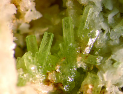
| Wilcza iron mine, Stanisławów, Gmina Męcinka, Jawor County, Lower Silesian Voivodeship, Poland | 51° 4' 20" N | 16° 0' 36" E | 0.0km (0.0 miles) | |
| Pillow lavas quarry, Sichów, Gmina Męcinka, Jawor County, Lower Silesian Voivodeship, Poland | 51° 4' 42" N | 16° 0' 42" E | 0.7km (0.4 miles) | |
| Stanisławów baryte mine, Pomocne, Gmina Męcinka, Jawor County, Lower Silesian Voivodeship, Poland | 51° 3' 39" N | 16° 0' 44" E | 1.3km (0.8 miles) | |
| Unnamed limestone quarry, Leszczyna, Gmina Złotoryja, Złotoryja County, Lower Silesian Voivodeship, Poland | 51° 4' 32" N | 15° 59' 30" E | 1.3km (0.8 miles) | |
| Le-33 borehole, Leszczyna, Gmina Złotoryja, Złotoryja County, Lower Silesian Voivodeship, Poland | 51° 4' 47" N | 15° 58' 58" E | 2.1km (1.3 miles) | |
| Leszczyna, Gmina Złotoryja, Złotoryja County, Lower Silesian Voivodeship, Poland | 51° 4' 59" N | 15° 58' 59" E | 2.2km (1.4 miles) | |
| Krzyżowa Góra quarry, Sichów, Gmina Męcinka, Jawor County, Lower Silesian Voivodeship, Poland | 51° 5' 28" N | 16° 2' 32" E | 3.1km (1.9 miles) | |
| Lena Cu-mine, Wilków, Gmina Złotoryja, Złotoryja County, Lower Silesian Voivodeship, Poland | 51° 5' 16" N | 15° 57' 57" E | 3.5km (2.2 miles) | |
| Bogaczowice, Gmina Męcinka, Jawor County, Lower Silesian Voivodeship, Poland | 51° 4' 20" N | 16° 3' 59" E | 4.0km (2.5 miles) | |
| Czartowska Skała, Pomocne, Gmina Męcinka, Jawor County, Lower Silesian Voivodeship, Poland | 51° 2' 15" N | 16° 1' 41" E | 4.1km (2.5 miles) | |
| Trupień quarry, Kondratów, Gmina Męcinka, Jawor County, Lower Silesian Voivodeship, Poland | 51° 3' 52" N | 15° 57' 7" E | 4.1km (2.6 miles) | |
| Dębowa Góra heaps, Męcinka, Gmina Męcinka, Jawor County, Lower Silesian Voivodeship, Poland | 51° 3' 12" N | 16° 4' 10" E | 4.7km (2.9 miles) | |
| Rudolf adit, Męcinka, Gmina Męcinka, Jawor County, Lower Silesian Voivodeship, Poland | 51° 3' 44" N | 16° 4' 53" E | 5.1km (3.2 miles) | |
| Krzeniów basalt quarry, Biegoszów, Gmina Świerzawa, Złotoryja County, Lower Silesian Voivodeship, Poland | 51° 3' 50" N | 15° 56' 3" E | 5.4km (3.3 miles) | |
| Hintermühlergang vein, Chełmiec, Gmina Męcinka, Jawor County, Lower Silesian Voivodeship, Poland | 51° 3' 14" N | 16° 4' 54" E | 5.4km (3.4 miles) | |
| Kozia Góra quarry, Wilków, Gmina Złotoryja, Złotoryja County, Lower Silesian Voivodeship, Poland | 51° 5' 40" N | 15° 56' 19" E | 5.6km (3.5 miles) | |
| Mecinka II basalt quarry, Męcinka, Gmina Męcinka, Jawor County, Lower Silesian Voivodeship, Poland | 51° 5' 0" N | 16° 5' 41" E | 6.0km (3.8 miles) | |
| Wilków sandstone quarry, Wilków, Gmina Złotoryja, Złotoryja County, Lower Silesian Voivodeship, Poland | 51° 5' 36" N | 15° 55' 47" E | 6.1km (3.8 miles) | |
| Muchowskie Wzgórza (Muchów Hills), Muchów, Gmina Męcinka, Jawor County, Lower Silesian Voivodeship, Poland | 51° 0' 57" N | 16° 2' 3" E | 6.5km (4.0 miles) | |
| Max Emil Alexander mine (Jerzyków heaps PGI #9-10), Chełmiec, Gmina Męcinka, Jawor County, Lower Silesian Voivodeship, Poland | 51° 2' 31" N | 16° 5' 32" E | 6.7km (4.1 miles) | |
| Chełmiec mine, Chełmiec, Gmina Męcinka, Jawor County, Lower Silesian Voivodeship, Poland | 50° 46' 29" N | 16° 13' 0" E | 6.8km (4.3 miles) | |
| Słup basalt quarry, Słup, Gmina Męcinka, Jawor County, Lower Silesian Voivodeship, Poland | 51° 5' 50" N | 16° 6' 11" E | 7.1km (4.4 miles) | |
| Kozów bazalt quarry, Gmina Złotoryja, Złotoryja County, Lower Silesian Voivodeship, Poland | 51° 8' 1" N | 15° 57' 49" E | 7.5km (4.7 miles) | |
| Męcinka basalt quarry, Męcinka, Gmina Męcinka, Jawor County, Lower Silesian Voivodeship, Poland | 51° 4' 47" N | 16° 7' 5" E | 7.6km (4.7 miles) | |
| Wilcza Góra quarry, Wilków, Gmina Złotoryja, Złotoryja County, Lower Silesian Voivodeship, Poland | 51° 6' 21" N | 15° 54' 48" E | 7.7km (4.8 miles) | |
| Winna Góra quarry, Piotrowice, Gmina Męcinka, Jawor County, Lower Silesian Voivodeship, Poland | 51° 3' 37" N | 16° 7' 13" E | 7.8km (4.9 miles) | |
| Żarecka Góra basalt quarry, Słup, Gmina Męcinka, Jawor County, Lower Silesian Voivodeship, Poland | 51° 5' 5" N | 16° 7' 25" E | 8.1km (5.0 miles) | |
| Mieszczańska Mtn., Złotoryja, Złotoryja County, Lower Silesian Voivodeship, Poland | 51° 7' 44" N | 15° 56' 4" E | 8.2km (5.1 miles) | |
| Czerwony Kamień quarry, Nowy Kościół, Gmina Świerzawa, Złotoryja County, Lower Silesian Voivodeship, Poland | 51° 5' 26" N | 15° 52' 48" E | 9.3km (5.8 miles) | |
| Dunino halloysite quarry, Gmina Krotoszyce, Legnica County, Lower Silesian Voivodeship, Poland | 51° 8' 43" N | 16° 4' 31" E | 9.3km (5.8 miles) | |


Trupień quarry, Kondratów, Gmina Męcinka, Jawor County, Lower Silesian Voivodeship, Poland