| Locality | Latitude | Longitude | Distance | Bearing |
|---|
| RZ shaft (Rudna mine), Polkowice, Gmina Polkowice, Polkowice County, Lower Silesian Voivodeship, Poland | 51° 31' 0" N | 16° 4' 19" E | 1.4km (0.9 miles) | |
| R-VI shaft (Rudna mine), Polkowice, Gmina Polkowice, Polkowice County, Lower Silesian Voivodeship, Poland | 51° 29' 9" N | 16° 4' 26" E | 2.0km (1.2 miles) | |
| PG shafts - Polkowice Główne (Polkowice-Sieroszowice mine), Polkowice, Gmina Polkowice, Polkowice County, Lower Silesian Voivodeship, Poland | 51° 29' 11" N | 16° 3' 32" E | 2.2km (1.3 miles) | |
| R-1/R-2 Rudna Główna shafts (Rudna mine), Polkowice, Gmina Polkowice, Polkowice County, Lower Silesian Voivodeship, Poland | 51° 30' 9" N | 16° 6' 18" E | 2.3km (1.4 miles) | |
| PZ shaft - Polkowice Zachodnie (Polkowice Sieroszowice mine), Polkowice, Gmina Polkowice, Polkowice County, Lower Silesian Voivodeship, Poland | 51° 30' 26" N | 16° 1' 15" E | 3.6km (2.2 miles) | |
| P-VII shaft (Polkowice-Sieroszowice mine), Sobin, Gmina Polkowice, Polkowice County, Lower Silesian Voivodeship, Poland | 51° 28' 22" N | 16° 2' 25" E | 4.1km (2.5 miles) | |
| Kaźmierzów borehole, Gmina Polkowice, Polkowice County, Lower Silesian Voivodeship, Poland | 51° 32' 36" N | 16° 3' 37" E | 4.5km (2.8 miles) | |
| R-IX shaft, Komorniki, Gmina Polkowice, Polkowice County, Lower Silesian Voivodeship, Poland | 51° 32' 7" N | 16° 7' 6" E | 4.7km (2.9 miles) | |
| PW-shaft (Polkowice-Sieroszowice mine), Szklary Górne, Gmina Lubin, Lubin County, Lower Silesian Voivodeship, Poland | 51° 27' 53" N | 16° 6' 8" E | 4.8km (3.0 miles) | |
| R-VII shaft (Rudna mine), Pieszkowice, Gmina Polkowice, Polkowice County, Lower Silesian Voivodeship, Poland | 51° 28' 48" N | 16° 8' 0" E | 5.0km (3.1 miles) | |
| RP shaft (Rudna mine), Tarnówek, Gmina Polkowice, Polkowice County, Lower Silesian Voivodeship, Poland | 51° 31' 3" N | 16° 8' 46" E | 5.3km (3.3 miles) | |
| SW-1'Jan Wyżykowski' shaft, Bądzów, Gmina Jerzmanowa, Głogów County, Lower Silesian Voivodeship, Poland | 51° 32' 9" N | 15° 58' 37" E | 6.0km (3.8 miles) | |
| LZ shafts (Lubin mine), Szklary Górne, Gmina Lubin, Lubin County, Lower Silesian Voivodeship, Poland | 51° 26' 45" N | 16° 7' 22" E | 7.3km (4.6 miles) | |
| SW-3 shaft (Polkowice-Sieroszowice mine), Sieroszowice, Gmina Radwanice, Polkowice County, Lower Silesian Voivodeship, Poland | 51° 32' 11" N | 15° 58' 42" E | 7.5km (4.6 miles) | |
| Sieroszowice 2 Mine, Sieroszowice, Gmina Radwanice, Polkowice County, Lower Silesian Voivodeship, Poland | 51° 32' 11" N | 15° 58' 41" E | 7.5km (4.7 miles) | |
| Obora sand pit, Szklary Górne, Gmina Lubin, Lubin County, Lower Silesian Voivodeship, Poland | 51° 26' 4" N | 16° 7' 10" E | 8.4km (5.2 miles) | |
| Sieroszowice S-1 borehole, Sieroszowice, Gmina Radwanice, Polkowice County, Lower Silesian Voivodeship, Poland | 51° 31' 44" N | 15° 56' 53" E | 9.1km (5.6 miles) | |
| Żelazny Most, Gmina Polkowice, Polkowice County, Lower Silesian Voivodeship, Poland | 51° 30' 50" N | 16° 12' 44" E | 9.7km (6.1 miles) | |
| Lubin Główny shafts (Lubin mine), Lubin, Lubin County, Lower Silesian Voivodeship, Poland | 51° 25' 58" N | 16° 9' 29" E | 9.9km (6.1 miles) | |
| L-VI shaft (Lubin mine), Koźlice, Gmina Rudna, Lubin County, Lower Silesian Voivodeship, Poland | 51° 27' 35" N | 16° 12' 14" E | 10.3km (6.4 miles) | |
| GG-1 shaft (Głogów Głęboki-Przemysłowy mine), Kwielice, Gmina Grębocice, Polkowice County, Lower Silesian Voivodeship, Poland | 51° 36' 6" N | 16° 6' 43" E | 11.2km (7.0 miles) | |
| SG-1'Św. Jakub' shaft (Polkowice-Sieroszowice mine), Gmina Radwanice, Polkowice County, Lower Silesian Voivodeship, Poland | 51° 35' 51" N | 16° 0' 31" E | 11.3km (7.0 miles) | |
| SW-4 shaft, Polkowice-Sieroszowice Mine, Łagoszów Mały, Gmina Jerzmanowa, Głogów County, Lower Silesian Voivodeship, Poland | 51° 36' 44" N | 16° 2' 19" E | 12.3km (7.6 miles) | |
| Buczyna borehole, Gmina Radwanice, Polkowice County, Lower Silesian Voivodeship, Poland | 51° 32' 43" N | 15° 54' 23" E | 12.4km (7.7 miles) | |
| LW 'Bolesław' shaft (Lubin mine), Lubin, Lubin County, Lower Silesian Voivodeship, Poland | 51° 24' 57" N | 16° 11' 10" E | 12.6km (7.8 miles) | |
| Rudna clay pit, Rudna, Gmina Rudna, Lubin County, Lower Silesian Voivodeship, Poland | 51° 29' 18" N | 16° 15' 41" E | 13.2km (8.2 miles) | |
| Jaczów sand pit III, Jaczów, Gmina Jerzmanowa, Głogów County, Lower Silesian Voivodeship, Poland | 51° 37' 37" N | 16° 3' 42" E | 13.7km (8.5 miles) | |
| Krzeczyn Mały sand pit, Krzeczyn Mały, Gmina Lubin, Lubin County, Lower Silesian Voivodeship, Poland | 51° 22' 44" N | 16° 5' 45" E | 14.0km (8.7 miles) | |
| Jaczów sand pit I, Jaczów, Gmina Jerzmanowa, Głogów County, Lower Silesian Voivodeship, Poland | 51° 37' 53" N | 16° 3' 48" E | 14.2km (8.8 miles) | |
| Jaczów sand pit II, Jaczów, Gmina Jerzmanowa, Głogów County, Lower Silesian Voivodeship, Poland | 51° 37' 54" N | 16° 3' 25" E | 14.3km (8.9 miles) | |
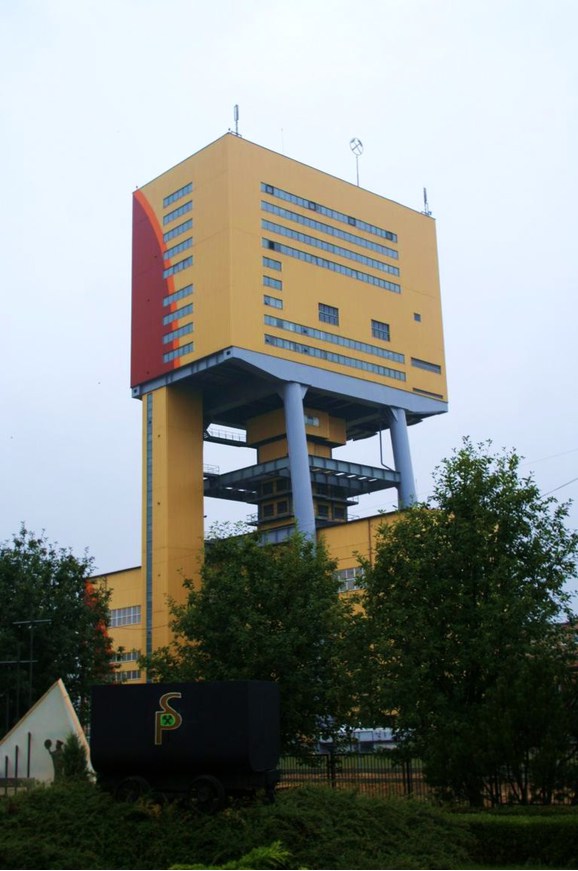
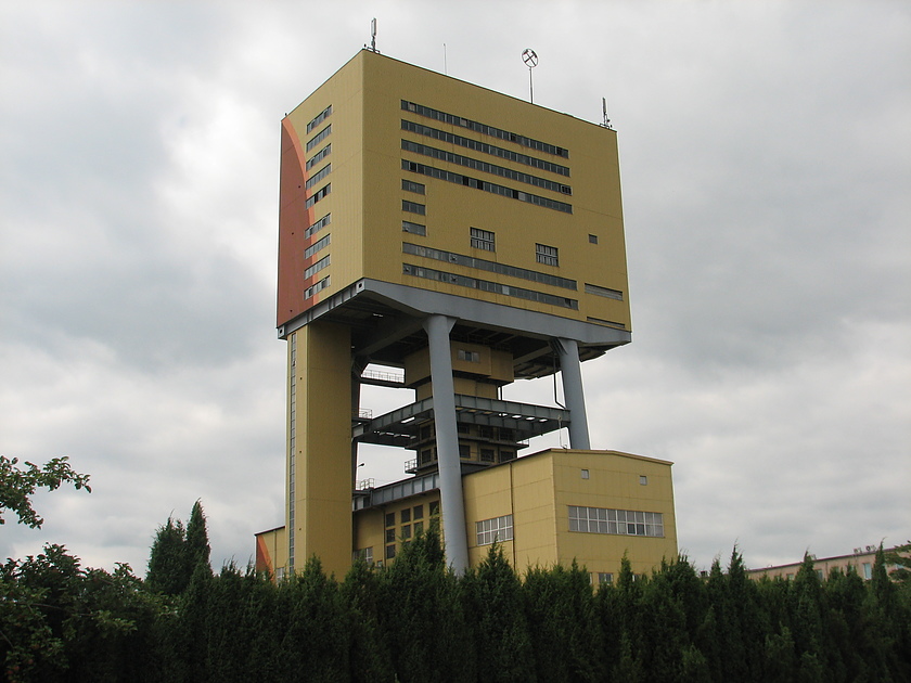


SW-1'Jan Wyżykowski' shaft, Bądzów, Gmina Jerzmanowa, Głogów County, Lower Silesian Voivodeship, Poland