| Locality | Latitude | Longitude | Distance | Bearing |
|---|
| Chyandour, Penzance, Cornwall, England, UK | 50° 7' 24" N | 5° 31' 50" W | 1.2km (0.8 miles) | |
| Long Rock, Ludgvan, Cornwall, England, UK | 50° 7' 42" N | 5° 30' 6" W | 1.5km (0.9 miles) | |
| West Wheal Darlington, Long Rock, Ludgvan, Cornwall, England, UK | 50° 7' 48" N | 5° 30' 3" W | 1.5km (0.9 miles) | |
| Long Rock Mine, Long Rock, Ludgvan, Cornwall, England, UK | 50° 7' 24" N | 5° 30' 2" W | 1.8km (1.1 miles) | |
| Boscreeg, Madron, Cornwall, England, UK | 50° 8' 48" N | 5° 32' 26" W | 2.1km (1.3 miles) | |
| Wheal Sarah, Boscreeg, Madron, Cornwall, England, UK | 50° 9' 1" N | 5° 32' 35" W | 2.5km (1.6 miles) | |
| Marazion Marsh, Ludgvan, Cornwall, England, UK | 50° 7' 47" N | 5° 29' 2" W | 2.7km (1.7 miles) | |
| Wherrytown, Penzance, Cornwall, England, UK | 50° 6' 44" N | 5° 32' 35" W | 2.8km (1.7 miles) | |
| Castle-an-Dinas Quarry, Higher Trenowin, Ludgvan, Cornwall, England, UK | 50° 9' 29" N | 5° 31' 11" W | 2.8km (1.7 miles) | |
| Wherry Mine, Wherrytown, Penzance, Cornwall, England, UK | 50° 6' 36" N | 5° 32' 20" W | 2.8km (1.8 miles) | |
| Wheal Darlington (Bog Mine; incl. East Wheal Darlington), Marazion Marsh, Ludgvan, Cornwall, England, UK | 50° 8' 0" N | 5° 28' 50" W | 2.9km (1.8 miles) | |
| Wheal Crab (Wheal Chippendale), Marazion, Cornwall, England, UK | 50° 7' 58" N | 5° 28' 46" W | 3.0km (1.8 miles) | |
| Lariggan rocks, Penzance, Cornwall, England, UK | 50° 6' 34" N | 5° 32' 33" W | 3.0km (1.9 miles) | |
| Marazion Beach, Marazion, Cornwall, England, UK | 50° 7' 27" N | 5° 28' 47" W | 3.1km (1.9 miles) | |
| Wheal Bolton, Crowlas, Ludgvan, Cornwall, England, UK | 50° 8' 29" N | 5° 28' 47" W | 3.1km (1.9 miles) | |
| Higher Trenowin, Ludgvan, Cornwall, England, UK | 50° 9' 44" N | 5° 30' 48" W | 3.3km (2.1 miles) | |
| Crowlas, Ludgvan, Cornwall, England, UK | 50° 8' 47" N | 5° 28' 43" W | 3.4km (2.1 miles) | |
| Newmill, Madron, Cornwall, England, UK | 50° 9' 4" N | 5° 33' 36" W | 3.5km (2.1 miles) | |
| Wheal Nancy, Rospeath Mine, Crowlas, Ludgvan, Cornwall, England, UK | 50° 8' 30" N | 5° 28' 27" W | 3.5km (2.2 miles) | |
| St Michael's Mount, Cornwall, England, UK | 50° 7' 2" N | 5° 28' 39" W | 3.6km (2.2 miles) | |
| Wheal Virgin, Marazion, Cornwall, England, UK | 50° 7' 51" N | 5° 28' 14" W | 3.6km (2.2 miles) | |
| Wheal Roberts (Wheal Speed), Newmill, Madron, Cornwall, England, UK | 50° 8' 49" N | 5° 34' 1" W | 3.6km (2.3 miles) | |
| Carnaquidden, Madron, Cornwall, England, UK | 50° 9' 39" N | 5° 32' 50" W | 3.6km (2.3 miles) | |
| Newlyn, Penzance, Cornwall, England, UK | 50° 6' 20" N | 5° 33' 0" W | 3.7km (2.3 miles) | |
| Carnaquidden Mine, Carnaquidden, Madron, Cornwall, England, UK | 50° 9' 42" N | 5° 32' 53" W | 3.8km (2.3 miles) | |
| Rospeath Mine, Crowlas, Ludgvan, Cornwall, England, UK | 50° 8' 30" N | 5° 28' 6" W | 3.9km (2.4 miles) | |
| New West Wheal Reeth (Baldhu Mine), Higher Trenowin, Ludgvan, Cornwall, England, UK | 50° 10' 0" N | 5° 30' 24" W | 3.9km (2.4 miles) | |
| Penlee Beach, Newlyn, Penzance, Cornwall, England, UK | 50° 5' 56" N | 5° 32' 32" W | 4.0km (2.5 miles) | |
| Bedlam Green China Clay Works, Higher Trenowin, Ludgvan, Cornwall, England, UK | 50° 10' 9" N | 5° 31' 32" W | 4.1km (2.5 miles) | |
| Mulfra, Madron, Cornwall, England, UK | 50° 9' 27" N | 5° 33' 54" W | 4.2km (2.6 miles) | |
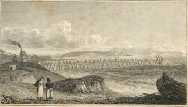
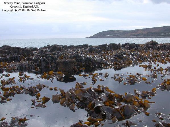


Wherry Mine, Wherrytown, Penzance, Cornwall, England, UK