| Locality | Latitude | Longitude | Distance | Bearing |
|---|
| Murchison meteorite, Murchison, City of Greater Shepparton, Victoria, Australia | 36° 37' 0" S | 145° 11' 59" E | 0.0km (0.0 miles) | |
| Comet Reef, Rushworth goldfield, Rushworth, Campaspe Shire, Victoria, Australia | 36° 34' 56" S | 145° 2' 49" E | 14.2km (8.8 miles) | |
| Birthday Reef, Rushworth goldfield, Rushworth, Campaspe Shire, Victoria, Australia | 36° 35' 18" S | 145° 2' 20" E | 14.7km (9.1 miles) | |
| Cockatoo Reef, Rushworth Goldfield, Rushworth, Campaspe Shire, Victoria, Australia | 36° 34' 57" S | 145° 2' 16" E | 15.0km (9.3 miles) | |
| Pioneer Reef, Rushworth Goldfield, Rushworth, Campaspe Shire, Victoria, Australia | 36° 35' 47" S | 145° 2' 0" E | 15.0km (9.3 miles) | |
| South Nuggety Reef (Nuggety Gully), Rushworth Goldfield, Rushworth, Campaspe Shire, Victoria, Australia | 36° 35' 30" S | 145° 1' 48" E | 15.4km (9.6 miles) | |
| Old Corroboree Reef, Rushworth goldfield, Rushworth, Campaspe Shire, Victoria, Australia | 36° 34' 52" S | 145° 1' 56" E | 15.5km (9.6 miles) | |
| Serpentine Reef, Rushworth goldfield, Rushworth, Campaspe Shire, Victoria, Australia | 36° 34' 38" S | 145° 1' 47" E | 15.8km (9.8 miles) | |
| Main Gully Reef, Rushworth Goldfield, Rushworth, Campaspe Shire, Victoria, Australia | 36° 35' 48" S | 145° 1' 20" E | 16.0km (9.9 miles) | |
| Specimen Hill Reef, Rushworth goldfield, Rushworth, Campaspe Shire, Victoria, Australia | 36° 35' 36" S | 145° 1' 23" E | 16.0km (9.9 miles) | |
| Main Reef, Rushworth Goldfield, Rushworth, Campaspe Shire, Victoria, Australia | 36° 35' 46" S | 145° 1' 20" E | 16.0km (10.0 miles) | |
| Nuggety Reef, Rushworth Goldfield, Rushworth, Campaspe Shire, Victoria, Australia | 36° 35' 41" S | 145° 1' 10" E | 16.3km (10.1 miles) | |
| Sons of Freedom, Rushworth goldfield, Rushworth, Campaspe Shire, Victoria, Australia | 36° 35' 31" S | 145° 1' 10" E | 16.3km (10.1 miles) | |
| South Devon Reef, Rushworth goldfield, Rushworth, Campaspe Shire, Victoria, Australia | 36° 35' 43" S | 145° 1' 3" E | 16.4km (10.2 miles) | |
| Camp reef (Camp Hill reef), Rushworth goldfield, Rushworth, Campaspe Shire, Victoria, Australia | 36° 35' 24" S | 145° 0' 57" E | 16.7km (10.4 miles) | |
| Scrub reef, Rushworth goldfield, Rushworth, Campaspe Shire, Victoria, Australia | 36° 35' 32" S | 145° 0' 44" E | 17.0km (10.5 miles) | |
| Royal George mine, Rushworth goldfield, Rushworth, Campaspe Shire, Victoria, Australia | 36° 35' 41" S | 145° 0' 42" E | 17.0km (10.5 miles) | |
| Growlers Hill, Rushworth goldfield, Rushworth, Campaspe Shire, Victoria, Australia | 36° 35' 23" S | 145° 0' 34" E | 17.3km (10.7 miles) | |
| Westlake Reef, Rushworth goldfield, Rushworth, Campaspe Shire, Victoria, Australia | 36° 34' 33" S | 145° 0' 45" E | 17.3km (10.8 miles) | |
| Dunlops, Rushworth goldfield, Rushworth, Campaspe Shire, Victoria, Australia | 36° 34' 30" S | 145° 0' 36" E | 17.6km (10.9 miles) | |
| West Growlers reef, Rushworth goldfield, Rushworth, Campaspe Shire, Victoria, Australia | 36° 35' 29" S | 145° 0' 19" E | 17.6km (10.9 miles) | |
| Chapman reef (Chapmans), Rushworth goldfield, Rushworth, Campaspe Shire, Victoria, Australia | 36° 35' 33" S | 145° 0' 8" E | 17.9km (11.1 miles) | |
| Mount Reef, Rushworth goldfield, Rushworth, Campaspe Shire, Victoria, Australia | 36° 35' 27" S | 145° 0' 6" E | 17.9km (11.1 miles) | |
| Union mine, Rushworth goldfield, Rushworth, Campaspe Shire, Victoria, Australia | 36° 34' 28" S | 145° 0' 4" E | 18.3km (11.4 miles) | |
| Hit or Miss (Hit or Miss reef), Rushworth goldfield, Rushworth, Campaspe Shire, Victoria, Australia | 36° 34' 24" S | 144° 59' 54" E | 18.6km (11.6 miles) | |
| Schleswig-Holstein, Rushworth goldfield, Rushworth, Campaspe Shire, Victoria, Australia | 36° 35' 9" S | 144° 59' 30" E | 18.9km (11.7 miles) | |
| Fletchers, Rushworth goldfield, Rushworth, Campaspe Shire, Victoria, Australia | 36° 34' 21" S | 144° 59' 42" E | 18.9km (11.8 miles) | |
| Mongolian, Rushworth goldfield, Rushworth, Campaspe Shire, Victoria, Australia | 36° 35' 3" S | 144° 59' 26" E | 19.0km (11.8 miles) | |
| Diamond, Rushworth goldfield, Rushworth, Campaspe Shire, Victoria, Australia | 36° 34' 45" S | 144° 59' 30" E | 19.0km (11.8 miles) | |
| Fossil, Rushworth goldfield, Rushworth, Campaspe Shire, Victoria, Australia | 36° 34' 43" S | 144° 59' 29" E | 19.1km (11.8 miles) | |

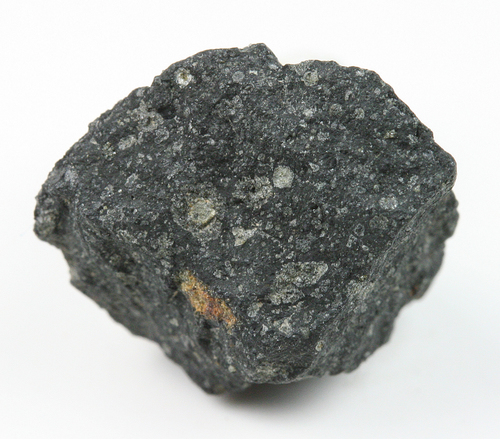
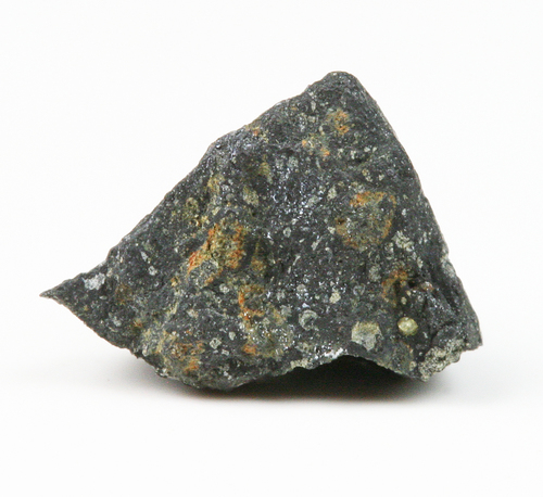


Murchison meteorite, Murchison, City of Greater Shepparton, Victoria, Australia