登录注册
Quick Links : Mindat手册The Rock H. Currier Digital LibraryMindat Newsletter [Free Download]
主页关于 MindatMindat手册Mindat的历史版权Who We Are联系我们于 Mindat.org刊登广告
捐赠给 MindatCorporate Sponsorship赞助板页已赞助的板页在 Mindat刊登 广告的广告商于 Mindat.org刊登广告
Learning CenterWhat is a mineral?The most common minerals on earthInformation for EducatorsMindat ArticlesThe ElementsThe Rock H. Currier Digital LibraryGeologic Time
搜索矿物的性质搜索矿物的化学Advanced Locality Search随意显示任何一 种矿物Random Locality使用minID搜索邻近产地Search Articles搜索词汇表更多搜索选项
搜索:
矿物名称:
地区产地名称:
关键字:
 
Mindat手册添加新照片Rate Photos产区编辑报告Coordinate Completion Report添加词汇表项目
Mining Companies统计会员列表Mineral MuseumsClubs & Organizations矿物展及活动The Mindat目录表设备设置The Mineral Quiz
照片搜索Photo GalleriesSearch by Color今天最新的照片昨天最新的照片用户照片相集过去每日精选照片相集Photography

Jerry A. Baird's Photo Gallery

TEN-97FTangeite CaCu(VO4)(OH) , Quartz SiO2

05105330014946304835989.jpg
Guadalupe Mine, Obregon, Cargo Muchacho Mining District, Cargo Muchacho Mountains, Imperial County, California, USA

Field of View: 1.4 mm

Field of view is 1.4 mm wide with greenish-yellow Tangeite on quartz. Jerry A. Baird specimen and photograph.
Photo ID: 711050     Uploaded by: Jerry A. Baird   Upload date: 2015-10-15   View Count: 340    Status: Public galleries    Type: Photo - 1024×775 (0.8 Mpix)

7U0-G6WAtacamite Cu2(OH)3Cl

06523290014946304835424.jpg
Blue Lizard Mine, Red Canyon Mining District, San Juan County, Utah, USA

Field of View: .55 mm

Field of view is .55 mm wide with green atacamite crystals. Jerry A Baird specimen and photo.

Mindat.org Photo of the Day - 21st Jul 2015
Copyright: © Jerry A. Baird      Photo ID: 692191     Uploaded by: Jerry A. Baird   Upload date: 2015-06-22   View Count: 1086    Status: Public galleries    Type: Photo - 1024×660 (0.7 Mpix)

209-0VGGold Au , Quartz SiO2

07926290014946304838327.jpg
American Boy Mine, Obregon, Cargo Muchacho Mining District, Cargo Muchacho Mountains, Imperial County, California, USA

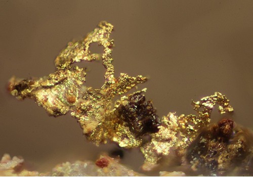
Field of View: 0.55 mm

FOV is 0.55 mm wide with gold on quartz. Jerry Baird specimen and photo.
Copyright: © Jerry A. Baird      Photo ID: 650312     Uploaded by: Jerry A. Baird   Upload date: 2014-11-30   View Count: 373    Status: Public galleries    Type: Photo - 1024×716 (0.7 Mpix)

AM7-CK8Wulfenite Pb(MoO4)

09028510014946304832162.jpg
Paymaster Mine, Midway Well, Paymaster Mining District, Chocolate Mountains, Imperial County, California, USA

Field of View: 3.3 mm

FOV is 3.3 mm wide with orange wulfenite crystals. Jerry Baird specimen and photo.
Copyright: © Jerry A. Baird      Photo ID: 650311     Uploaded by: Jerry A. Baird   Upload date: 2014-11-30   View Count: 375    Status: Public galleries    Type: Photo - 683×1024 (0.7 Mpix)

L95-P91Hemimorphite Zn4Si2O7(OH)2·H2O

01888730014946304843514.jpg
Paymaster Mine, Midway Well, Paymaster Mining District, Chocolate Mountains, Imperial County, California, USA

Field of View: 2.5 mm

FOV is 2.5 mm wide with transparent hemimorphite crystals. Jerry Baird specimen and photo.
Photo ID: 650306     Uploaded by: Jerry A. Baird   Upload date: 2014-11-30   View Count: 329    Status: Public galleries    Type: Photo - 1024×683 (0.7 Mpix)

0X9-NFECalcite CaCO3 , Hematite Fe2O3

03354960014946304847070.jpg
Copperstone Mine, La Paz Mining District, Dome Rock Mountains, La Paz County, Arizona, USA

Field of View: 1.5 mm

Field of view is 1.5 mm wide with transparent calcite crystals resting on bladed hematite crystals. Jerry A Baird specimen and photo.
Photo ID: 647518     Uploaded by: Jerry A. Baird   Upload date: 2014-11-17   View Count: 301    Status: Public galleries    Type: Photo - 1024×683 (0.7 Mpix)

9K8-156Chrysocolla Cu2-xAlx(H2-xSi2O5)(OH)4·nH2O, x < 1 , Hematite Fe2O3

04864330014946304845652.jpg
Copperstone Mine, La Paz Mining District, Dome Rock Mountains, La Paz County, Arizona, USA

Field of View: 3.0 mm

Field of view is 3.0 mm wide with bluish chrysocolla on hematite. Jerry A Baird specimen and photo.
Photo ID: 647517     Uploaded by: Jerry A. Baird   Upload date: 2014-11-17   View Count: 499    Status: Public galleries    Type: Photo - 1024×719 (0.7 Mpix)

Copperstone Mine Map

06232460014946304842336.jpg
Copperstone Mine, La Paz Mining District, Dome Rock Mountains, La Paz County, Arizona, USA

Map of the surface and underground workings at the Copperstone Mine. The purple colored outline indicates an open pit 500 feet deep. There are two portals which are not indicated on the map, a north portal and a west portal that lead to underground workings.

The Copperstone Mine is still an active mine.
Photo ID: 647510     Uploaded by: Jerry A. Baird   Upload date: 2014-11-17   View Count: 515    Status: Public galleries    Type: Photo - 1024×1352 (1.4 Mpix)

R44-LM0Malachite Cu2(CO3)(OH)2

08290150014946304848731.jpg
Copperstone Mine, La Paz Mining District, Dome Rock Mountains, La Paz County, Arizona, USA

Field of View: 4.5 mm

Field of view is 4.5 mm wide with green malachite crystals. Specimen received from Jordan Klug, Thank you Jordan. Jerry A Baird specimen and photo.
Photo ID: 647424     Uploaded by: Jerry A. Baird   Upload date: 2014-11-17   View Count: 397    Status: Public galleries    Type: Photo - 1024×683 (0.7 Mpix)

Mine Engineer and Wife

09332910014946304842225.jpg
Copperstone Mine, La Paz Mining District, Dome Rock Mountains, La Paz County, Arizona, USA

Photo of Matt and Jordan Klug in front of the north portal at the Copperstone Mine. Matt is the mine engineer for the Copperstone Mine.
Jerry A. Baird photo.
Photo ID: 647409     Uploaded by: Jerry A. Baird   Upload date: 2014-11-17   View Count: 704    Status: Public galleries    Type: Photo - 672×1024 (0.7 Mpix)
Page 1 of 33 (1 to 10 of 330 total)
1 2 3 4 5 6 7 8 9 10 11 12 13 14 15 16 17 ...
 
矿物 and/or 产地  
Mindat Discussions Facebook Logo Instagram Logo Discord Logo
版权所有© mindat.org1993年至2024年,除了规定的地方。 Mindat.org全赖于全球数千个以上成员和支持者们的参与。
隐私政策 - 条款和条款细则 - 联络我们 - Report a bug/vulnerability Current server date and time: 2024.4.26 08:25:14
Go to top of page