| Locality | Latitude | Longitude | Distance | Bearing |
|---|
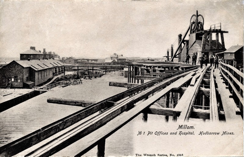
| Hodbarrow Mine, Millom, Copeland, Cumbria, England, UK | 54° 11' 44" N | 3° 14' 57" W | 2.9km (1.8 miles) | |
| Waterblean Mine, Millom Without, Copeland, Cumbria, England, UK | 54° 13' 49" N | 3° 15' 56" W | 3.8km (2.4 miles) | |
| Roanhead Mine, Dalton Town with Newton, Barrow-in-Furness, Cumbria, England, UK | 54° 10' 8" N | 3° 13' 4" W | 5.9km (3.7 miles) | |
| Park Mines, Askam and Ireleath, Barrow-in-Furness, Cumbria, England, UK | 54° 10' 8" N | 3° 12' 9" W | 6.8km (4.2 miles) | |
| Black Combe, Whicham, Copeland, Cumbria, England, UK | 54° 15' 27" N | 3° 19' 42" W | 6.9km (4.3 miles) | |
| Greenscoe Quarry, Dalton Town with Newton, Barrow-in-Furness, Cumbria, England, UK | 54° 10' 28" N | 3° 11' 25" W | 7.2km (4.5 miles) | |
| Anty Cross Mine, Dalton Town with Newton, Barrow-in-Furness, Cumbria, England, UK | 54° 9' 4" N | 3° 10' 50" W | 9.1km (5.6 miles) | |
| Lindal Moor Mine, Lindal & Marton, Barrow-in-Furness, Cumbria, England, UK | 54° 10' 42" N | 3° 9' 24" W | 9.1km (5.7 miles) | |
| Crookley Beck, Bootle, Copeland, Cumbria, England, UK | 54° 17' 4" N | 3° 19' 43" W | 9.7km (6.0 miles) | |
| Kirkby Slate Quarries, Kirkby Ireleth, South Lakeland, Cumbria, England, UK | 54° 14' 44" N | 3° 9' 14" W | 10.4km (6.4 miles) | |
| Yarlside Mines, Dalton Town with Newton, Barrow-in-Furness, Cumbria, England, UK | 54° 7' 50" N | 3° 10' 53" W | 10.5km (6.6 miles) | |
| Stainton Quarry, Stainton with Adgarley, Urswick, South Lakeland, Cumbria, England, UK | 54° 8' 46" N | 3° 9' 16" W | 10.8km (6.7 miles) | |
| Stank Mine, Barrow-in-Furness, Cumbria, England, UK | 54° 7' 31" N | 3° 10' 42" W | 11.1km (6.9 miles) | |
| Stainton with Adgarley, Urswick, South Lakeland, Cumbria, England, UK | 54° 8' 34" N | 3° 9' 2" W | 11.2km (7.0 miles) | |
| Unnamed Quarries west of Rake Farm, Osmotherley, South Lakeland, Cumbria, England, UK | 54° 13' 38" N | 3° 7' 33" W | 11.3km (7.0 miles) | |
| Gawthwaite High Quarry, Blawith and Subberthwaite, South Lakeland, Cumbria, England, UK | 54° 14' 57" N | 3° 8' 1" W | 11.7km (7.3 miles) | |
| Buckbarrow Beck Veins, Waberthwaite, Copeland, Cumbria, England, UK | 54° 18' 25" N | 3° 19' 35" W | 12.1km (7.5 miles) | |
| Gawthwaite Quarry, Blawith and Subberthwaite, South Lakeland, Cumbria, England, UK | 54° 15' 7" N | 3° 7' 34" W | 12.3km (7.6 miles) | |
| Roosecote Sand Pit, Barrow-in-Furness, Cumbria, England, UK | 54° 6' 14" N | 3° 10' 49" W | 12.9km (8.0 miles) | |
| Unnamed Quarry north of Gawthwaite, Blawith and Subberthwaite, South Lakeland, Cumbria, England, UK | 54° 15' 24" N | 3° 7' 4" W | 13.0km (8.1 miles) | |
| Long Garth, Ulpha, Copeland, Cumbria, England, UK | 54° 19' 7" N | 3° 15' 16" W | 13.5km (8.4 miles) | |
| Ulpha Copper Mine, Ulpha, Copeland, Cumbria, England, UK | 54° 19' 13" N | 3° 15' 0" W | 13.7km (8.5 miles) | |
| Baycliff Quarry, Aldingham, South Lakeland, Cumbria, England, UK | 54° 8' 39" N | 3° 6' 5" W | 13.9km (8.6 miles) | |
| Sea Wood Mine, Aldingham, South Lakeland, Cumbria, England, UK | 54° 9' 14" N | 3° 4' 41" W | 14.9km (9.2 miles) | |
| Hesk Fell Mine, Ulpha, Copeland, Cumbria, England, UK | 54° 20' 11" N | 3° 16' 8" W | 15.3km (9.5 miles) | |
| Holehouse Gill Mine, Ulpha, Copeland, Cumbria, England, UK | 54° 20' 11" N | 3° 16' 8" W | 15.3km (9.5 miles) | |
| Waberthwaite Quarry, Waberthwaite, Copeland, Cumbria, England, UK | 54° 20' 10" N | 3° 21' 57" W | 15.9km (9.9 miles) | |
| West of Devoke Water, Muncaster, Copeland, Cumbria, England, UK | 54° 21' 34" N | 3° 18' 35" W | 17.8km (11.1 miles) | |
| Water Crag, Eskdale, Copeland, Cumbria, England, UK | 54° 21' 50" N | 3° 18' 13" W | 18.3km (11.4 miles) | |
| Brant Rake Mine, Eskdale, Copeland, Cumbria, England, UK | 54° 22' 29" N | 3° 18' 36" W | 19.5km (12.1 miles) | |


Hodbarrow Mine, Millom, Copeland, Cumbria, England, UK