| Locality type: | Mine |
| Classification |
|---|
|
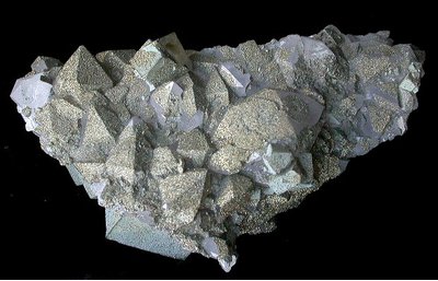
| Species: | Pyrite |
| Formula: | FeS2 |
| Confirmation |
|---|
|
| Validity: | Believed Valid |
| Associated Minerals Based on Photo Data: |
|---|
|
| Quartz | ⓘ41 photos of Pyrite associated with Quartz at this locality. |
| Fluorite | ⓘ28 photos of Pyrite associated with Fluorite at this locality. |
| Calcite | ⓘ23 photos of Pyrite associated with Calcite at this locality. |
| Dolomite | ⓘ5 photos of Pyrite associated with Dolomite at this locality. |
| Chlorite Group | ⓘ4 photos of Pyrite associated with Chlorite Group at this locality. |
| Data |
|---|
|
| Mineral Data: | Click here to view Pyrite data |
| Locality Data: | Click here to view Cambokeels Mine (Cammock Isle Mine; Cumnock Isle Mine; Cammock Eals Mine), Westgate, Stanhope, County Durham, England, UK |
| Photo Gallery | View Gallery (4 photos) |
| Data Identifiers |
|---|
|
| Mindat Occurrence Record ID: | 9016 |
| Long-form Identifier: | 1:3:9016:2 |
| GUID (UUID V4): | a4d35472-eb5c-42f3-a5ec-bf2a4106bb52 |
| Nearest other occurrences of Pyrite |
|---|
|
|
| 1.2km (0.7 miles) | ⓘHeights Quarry, Westgate, Stanhope, County Durham, England, UK |
| 2.0km (1.2 miles) | ⓘEastgate Quarry, Eastgate, Stanhope, County Durham, England, UK |
| 2.9km (1.8 miles) | ⓘLower Slitt Hushes, Westgate, Stanhope, County Durham, England, UK |
| 4.5km (2.8 miles) | ⓘBoltsburn Mine, Rookhope, Stanhope, County Durham, England, UK |
| 4.7km (2.9 miles) | ⓘGreenfoot Quarry, Stanhope, County Durham, England, UK |
| 6.7km (4.2 miles) | ⓘBlackdene Mine, Ireshopeburn, Stanhope, County Durham, England, UK |
| 7.1km (4.4 miles) | ⓘGroverake Mine, Rookhope, Stanhope, County Durham, England, UK |
| 7.3km (4.5 miles) | ⓘDiana Maria Mine, Rogerley Quarry, Stanhope, County Durham, England, UK |
| 7.6km (4.7 miles) | ⓘFrazer's Hush Mine, Rookhope, Stanhope, County Durham, England, UK |
| 7.9km (4.9 miles) | ⓘHarthope Head Quarries, St. John's Chapel, Stanhope, County Durham, England, UK |
| References |
|---|
|
|


Cambokeels Mine, Westgate, Stanhope, County Durham, England, UK