| Classification |
|---|
|
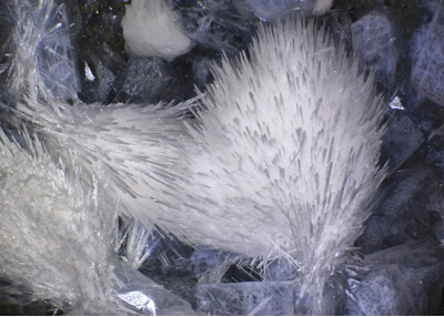
| Species: | Thomsonite-Ca |
| Formula: | NaCa2[Al5Si5O20] · 6H2O |
| Comments: | found in cavities in basalt |
| Confirmation |
|---|
|
| Validity: | Believed Valid |
| Associated Minerals Based on Photo Data: |
|---|
|
| Phillipsite Subgroup | ⓘ7 photos of Thomsonite-Ca associated with Phillipsite Subgroup at this locality. |
| Fluorapophyllite-(K) | ⓘ4 photos of Thomsonite-Ca associated with Fluorapophyllite-(K) at this locality. |
| Mesolite | ⓘ2 photos of Thomsonite-Ca associated with Mesolite at this locality. |
| Gyrolite | ⓘ1 photo of Thomsonite-Ca associated with Gyrolite at this locality. |
| Gmelinite Subgroup | ⓘ1 photo of Thomsonite-Ca associated with Gmelinite Subgroup at this locality. |
| Tacharanite | ⓘ1 photo of Thomsonite-Ca associated with Tacharanite at this locality. |
| Data |
|---|
|
| Mineral Data: | Click here to view Thomsonite-Ca data |
| Locality Data: | Click here to view Devils Backbone, North Fork John Day River, Grant County, Oregon, USA |
| Photo Gallery | View Gallery (10 photos) |
| Data Identifiers |
|---|
|
| Mindat Occurrence Record ID: | 46323 |
| Long-form Identifier: | 1:3:46323:6 |
| GUID (UUID V4): | 91a2abad-1af6-4cdd-8eee-c541e776529d |
| Nearest other occurrences of Thomsonite-Ca |
|---|
|
|
| 4.8km (3.0 miles) | ⓘSixmile Creek, Ritter, Grant County, Oregon, USA |
| 10.8km (6.7 miles) | ⓘRitter Hot Springs, Ritter, Grant County, Oregon, USA |
| 11.8km (7.3 miles) | ⓘMiddle Fork Cliffs, Ritter, Grant County, Oregon, USA |
| 15.0km (9.3 miles) | ⓘRoadside Quarry, Ritter, Grant County, Oregon, USA |
| 15.1km (9.4 miles) | ⓘUpper Ritter Quarry, Ritter, Grant County, Oregon, USA |
| 39.2km (24.3 miles) | ⓘBig Bend, Kimberley, Grant County, Oregon, USA |
| 39.6km (24.6 miles) | ⓘBurnt Cabin Creek, Spray, Wheeler County, Oregon, USA |
| 47.0km (29.2 miles) | ⓘIndian Rock Lookout, Middle Fork John Day River, Grant County, Oregon, USA |
| 51.5km (32.0 miles) | ⓘLower Kahler Creek, Spray, Wheeler County, Oregon, USA |
| 52.5km (32.7 miles) | ⓘBeech Creek Quarry, Mount Vernon, Grant County, Oregon, USA |
| References |
|---|
|
|
| Reference Search (possible matching items) |
|---|
 | | Book (edition) | | book is respectfully dedicated to the memory of Dr. John Sinkankas for his kind initiative and support to...more structural sites, e.g. jahnsite(~fa). jahn ite-(Ca.\1nMn). etc. Other examples are pump~U);te-(Fe:,...or numerous zeolites. e.g. gmelinite- a. gmelinite-Ca, etc. For the fonnerly used prefixes such as Greek...both enclosed in square brackets, e.g. fluorapatite Ca[Fl(PO 4)3] or euchroite 0.1 2[OHIAsO 4]•3H 2O. This...abbreviations: Rep. (republic), prov. (province), co. (county), munic. (municipio), pref. (prefecture), dept |
|


Devils Backbone, North Fork John Day River, Grant County, Oregon, USA