Moinhos dos Catelões, Gaeiras, Óbidos, Leiria, Portugali
| Regional Level Types | |
|---|---|
| Moinhos dos Catelões | - not defined - |
| Gaeiras | Parish |
| Óbidos | Municipality |
| Leiria | District |
| Portugal | Country |
This page is currently not sponsored. Click here to sponsor this page.


Latitude & Longitude (WGS84):
39° 22' 13'' North , 9° 7' 29'' West
Latitude & Longitude (decimal):
Köppen climate type:
Nearest Settlements:
| Place | Population | Distance |
|---|---|---|
| Óbidos | 11,187 (2018) | 2.9km |
| Caldas da Rainha | 27,378 (2018) | 3.8km |
| Vidais | 1,155 (2018) | 6.5km |
| Salir de Matos | 2,583 (2018) | 7.3km |
| Alvorninha | 2,987 (2018) | 7.7km |
Mindat Locality ID:
245640
Long-form identifier:
mindat:1:2:245640:2
GUID (UUID V4):
db96d360-11e4-4758-8837-32bfea139825
Name(s) in local language(s):
Moinho do Catulão (*), Gaeiras, Óbidos, Distrito de Leiria, Portugal
Dolerite vein with zeolitisation. Had one quarry now grounded and without evidence.
"Catulão" is refered by Prof. Miguel Montenegro de Andrade but in the Gaeiras Parish Monography the locality is always refered as "Moinhos dos Catelões".
- Doleritic vein of Gaeiras
Gaeiras is located between the Tifónica Valley of Caldas da Rainha and the A-dos-Francos Syncline.
It is in this area that the Gaeiras Doleritic Vein is situated, spanning approximately 6 kilometers between Quinta das Janelas and S. Gregório da Fanadia, with a direction of N 67º W.
The vein crosses the "abnormal contact" that marks the eastern limit of the Tifónica Valley and extends eastward, cutting through the "upper sandstones" and branching into several parallel arms.
At Quinta das Janelas, thermal springs (sulfurous waters) known as Caldas das Gaeiras emerge, with relatively abundant flows that are discharged into the nearby stream. The smell and the warmth of these waters bear witness to their sulfurous nature. Gaierenses residents tell stories of the water releasing "steam" along its course during winter.
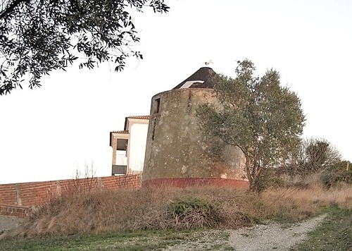
From Quinta das Janelas to Catelões, the vein is covered with vegetation. Near Mr. Manuel's mill (the first mill in Catelões), located at the southern end of Gaeiras, on a small hill about 100 meters above sea level, one can enjoy a vast panorama featuring Óbidos to the west and a series of small villages to the south, scattered across hills and valleys.
Walking along the vein in the Catelões area, we come across the second mill in Catelões. Besides the cultivated land surrounding it being composed of dolerite, parts of the mill itself were constructed with this rock.
The landscape remains similar from Catelões to Quinta do Santana until we reach the old quarry. Here, the rock is highly weathered, covered in vegetation, and surrounded by farmlands. Residents of Quinta de Santana recall that quarrying in this area was short-lived because there was little dolerite, which was not economically viable, and the ground frequently developed "fissures."
Continuing our walk, we reach the Casais dos Camarnais, where the Camarnais mill used to stand. To the east of the Camarnais mill, the vein forms two local enlargements that appear to correspond to chimneys. This mill was made of wood and is now only remembered by Mrs. Alice, the owner of the land where it once stood. Covered by pine forests and cultivated fields, this vein extends to S. Gregório da Fanadia.
While searching for this vein, I discovered a quarry near A-dos-Francos called "Jobasalto," which is not referenced on the geological map. However, since the rock is similar, I dare to mention it, assuming that this vein may be of a similar age to the Gaeiras Vein.
Macroscopically, the rock of the Gaeiras Vein is defined as a fine-grained olivine dolerite, and microscopic examination reveals microlites of plagioclase and small crystals of augite and olivine under a magnifying glass. Chemically, this rock is considered a basalt basatinoid. Radioactive dating using the K-Ar method on the basalt from this vein, studied by M. Portugal Ferreira and Regêncio Macedo C. A., confirms its age falls within the range of 130-135 million years, placing it in the third cycle of Intra-Mesozoic volcanism.
Portuguese - Filão dolerítico das Gaeiras
Gaeiras situa-se entre o Vale Tifónica de Caldas da Rainha e o Sinclinal de A-dos-Francos.
É nesta área que se situa o Filão das Gaeiras, que possui cerca de 6 km de comprimento, entre a Quinta das Janelas e S. Gregório da Fanadia, com direcção de N 67º W.
O fião atravessa o "contacto anormal" que limita, a leste, o Vale Tifónico e prolonga-se para leste cortando os “grés superiores” e dividindo-se em vários ramos paralelos.
Na Quinta das Janelas brotam nascentes termais (águas sulfurosas), designadas por Caldas das Gaeiras, com caudais de relativa abundância que são lançados na vizinha ribeira. O cheiro é testemunho de água sulfurosa, assim como o calor que esta águas oferecem. Contam os residentes Gaierenses que no Inverno a água, ao longo do seu curso, liberta “fumo”.
Desde a Quinta das Janelas até aos Catelões, o filão encontra-se coberto por vegetação. Perto do moinho do Sr. Manuel (primeiro moinho dos Catelões), situado na extremidade sul de Gaeiras, num pequeno cabeço a cerca de 100 m do nível do mar, domina um vasto panorama de onde sobressai, a oeste, Óbidos, e, a sul, uma série de pequenas povoações que se estendem por montes e vales.
Caminhando sobre o filão na zona dos Catelões, deparamos com o segundo moinho dos Catelões. Além do terreno cultivado que o rodeia apresentar dolerito, o próprio moinho foi construido em algumas zonas com esta rocha.
A paisagem dos Catelões até à Quinta do Santana é identica até chegarmos à antiga pedreira. Aqui a rocha encontra-se muito alterada, estando coberta por vegetação e rodeada por campos de cultura. Contam os residentes da Quinta de Santana que a exploração da pedreira durou pouco tempo porque havia pouco dolerito o que não era economicamente rentável, e, além disso, o chão abria “fendas” com frequência.
Continuando a caminhada chegamos aos Casais dos Camarnais onde antigamente existia o moinho dos Camarnais. A leste do moinho dos Camarnais o filão forma dois alargamentos locais que parecem corresponder a chaminés. Este moinho era de madeira e neste momento apenas permanece na memória da Sra. Alice, proprietária dos terrenos onde este se situava. Coberto por pinhais e campos de cultivo, este filão prolonga-se até S. Gregório da Fanadia.
Aquando da procura deste filão, descobri uma pedreira nas redondezas de A-dos-Francos, a “Jobasalto”, que não encontrando referenciado na carta geológica, e sendo a rocha idêntica, atrevo-me a referenciá-la, partindo da hipótese que este filão será de datação semelhante ao filão das Gaeiras.
A rocha do filão das Gaeiras é definida, macroscopicamente, como um dolerito olivínico de grão fino, observando-se à lupa microlites de plagioclase e pequenos cristais de augite e olivina. Químicamente esta rocha é considerada um basalto basatinóide. Através da datação radioativa pelo método K-Ar do basalto deste filão, estudado por M. Portugal Ferreira e Regêncio Macedo C. A., confirma-se que a sua idade se situa no intervalo 130-135 milhões de anos, pertencendo ao terceiro ciclo do vulcanismo Intra-Mesozóico.
Artigo de Madalena Gomes Capinha, Monografia de Gaeiras, Freguesia de Gaeiras 2012.
(Rui Nunes, December 2012).
Mindat Articles
Zeolites@Portugal by Martins da Pedra http://www.mindat.org/article.php/1608
Select Mineral List Type
Standard Detailed Gallery Strunz Chemical ElementsDetailed Mineral List:
| ⓘ Augite Formula: (CaxMgyFez)(Mgy1Fez1)Si2O6 References: |
| ⓘ 'Fayalite-Forsterite Series' References: |
| ⓘ Natrolite Formula: Na2Al2Si3O10 · 2H2O |
Gallery:
List of minerals arranged by Strunz 10th Edition classification
| Group 9 - Silicates | |||
|---|---|---|---|
| ⓘ | Augite | 9.DA.15 | (CaxMgyFez)(Mgy1Fez1)Si2O6 |
| ⓘ | Natrolite | 9.GA.05 | Na2Al2Si3O10 · 2H2O |
| Unclassified | |||
| ⓘ | 'Fayalite-Forsterite Series' | - | |
List of minerals for each chemical element
| H | Hydrogen | |
|---|---|---|
| H | ⓘ Natrolite | Na2Al2Si3O10 · 2H2O |
| O | Oxygen | |
| O | ⓘ Augite | (CaxMgyFez)(Mgy1Fez1)Si2O6 |
| O | ⓘ Natrolite | Na2Al2Si3O10 · 2H2O |
| Na | Sodium | |
| Na | ⓘ Natrolite | Na2Al2Si3O10 · 2H2O |
| Mg | Magnesium | |
| Mg | ⓘ Augite | (CaxMgyFez)(Mgy1Fez1)Si2O6 |
| Al | Aluminium | |
| Al | ⓘ Natrolite | Na2Al2Si3O10 · 2H2O |
| Si | Silicon | |
| Si | ⓘ Augite | (CaxMgyFez)(Mgy1Fez1)Si2O6 |
| Si | ⓘ Natrolite | Na2Al2Si3O10 · 2H2O |
| Ca | Calcium | |
| Ca | ⓘ Augite | (CaxMgyFez)(Mgy1Fez1)Si2O6 |
| Fe | Iron | |
| Fe | ⓘ Augite | (CaxMgyFez)(Mgy1Fez1)Si2O6 |
Other Regions, Features and Areas containing this locality
This page contains all mineral locality references listed on mindat.org. This does not claim to be a complete list. If you know of more minerals from this site, please register so you can add to our database. This locality information is for reference purposes only. You should never attempt to
visit any sites listed in mindat.org without first ensuring that you have the permission of the land and/or mineral rights holders
for access and that you are aware of all safety precautions necessary.
References


Moinhos dos Catelões, Gaeiras, Óbidos, Leiria, Portugal