 | | Journal (article/letter/editorial) |
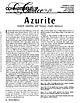
| apparently quite unusual. Pseudomorphs of copper, chalcocite, jarosite, atacamite, willemite, smithsonite...brochantite, antlerite, atacamite, native copper, and chalcocite. Although the primary deposits from which azurite...of copper sulfide occurrences in Hancock and Washington Figure IA. A fine 2.5-cm-high azurite from Tsumeb...Hill, Carroll County, Maryland; French Creek and Phoenixville, Pennsylvania; the Pontiac mine, Halifax County...Sterling Hill, Sussex County, New Jersey; and the Clegg and Snipes mines, Chatham County, North Carolina. |
 | | Report (issue) |
| GEOLOGY AND EARTH RESOURCES DIVISION OLYMPIA, WASHiNGTON 98504 METAL MINES OF WASHINGTONPRELIMINARY REPORT...DERKEY NANCY L. JOSEPH and RAYMOND LASMANIS WASHINGTON DIVISION OF GEOLOGY AND EARTH RESOURCES OPEN...Earth Resources standards and nomenclature. 1, WASHINGTON STATE DEPARTMENT OF Natural Resources Brian...DERKEY NANCY L. JOSEPH and RAYMOND LASMANIS WASHINGTON DIVISION OF GEOLOGY AND EARTH RESOURCES OPEN...standards and nomenclature. • CONTENTS Page Page County and site name Kelly Camp Kettle Key East Knob |
 | | Book |
| Bart Cannon 1975 CORD ILLERAN Mercer Island, Washington Lilli liliiiLt' 111? KLi-KlLLLIlrVlIlI Copyright...Cordilleran 18 Holly Hill Drive Mercer Island, Washington 98040 COVER ILLUSTRATION: Amethyst scepter heads...milky quartz stems. Denny Mountain area of King County. Specimen from the collection of Cary A. Maykut...publications dealing with the various aspects of Washington State's diverse mineral wealth exist, but none..."Minerals of Washington" represents an attempt to begin such a cata logue. "Minerals of Washington" shall |
 | | Report (Issue volume) |
| State of Washington ARTHUR B. LANGLIE, Governor Department of Conservation and Development W. A. GALBRAITH...GLOVER, Supervisor Bulletin No. 37 INVENTORY OF WASHINGTON MINERALS PART II METALLIC MINERALS By MARSHALL...Volume 2 - MAPS STATE PRINTING PLANT. OLYMPIA, WASHINGTON lll!UI For sale by Department of Conservation...volumes-text and maps) $4.50. INVENTORY OF WASHINGTON MINERALS PART II METALLIC MINERALS Volume 1...Bulletin 33, "Nonmetallic Mineral Resources of Washington," published in 1936. Since then the catalogue |
 | | Report (volume) |
| COMPILED BY SAMUEL SANFORD AND RALPH W. STONE WASHINGTON GOVERNMENT PRINTING OFFICE 1914 USEFUL MINERALS...it helpful to refer to Survey Bulletin 507, "The mining districts of the western United States," and to...abundant, it may have been completely exhausted by mining or quarrying. Deposits of minerals of wide distribution...because they occur in sufficient quantity to warrant mining for their usual products but because they furnish...STATES. Tennessee........Mr. George H. Ashley, Washington, D. C. Texas............Dr. William B. Phillips |
 | | Book |
| PUBLISHED BY Western Mineral Exchange Seattle, Washington 1941 t Copyright 1941 WESTERN MINERAL EXCHANGE...volume is dedicated is four-fold: (1) To locate by mine, deposit, or community those mineralized areas of...Co. Hematite CALERA, Shelby Co. Wavkllite CLAY COUNTY, Sec. 24. T. 19 S R., 7 E. STATUARY, Coosa Co...Co., (W. border of* Marble Crystalline TALLADEGA COUNTY Marble, (crystalline) VALLEY HEAD, DeKalb Co. Hematite...VILLAGE SPRINGS, Blount Co. Hematite WOODS COPPER MINE, Cloaburne Co. Sphalerite ARIZONA COVEI.I.ITE |
 | | Report (issue) |
| INTERIOR GEOLOGICAL SURVEY MINERAL RESOURCES OF ELKO COUNTY, NEVADA By Roscoe M. Smith Prepared in cooperation...Acknowledgment -Mining districts Commodities Production Descriptions of mining districts . Alder district-Aura district...district -Beaver district Black Mountain district Bootstrap district Burner district Burns Basin district--...-Carlin district Cave Creek district ----Charleston district_--Coal Mine district~ Contact district Cornucopia...Cornucopia district - -Corral Creek district - Decoy district Delano district Delker districtDivide district |
 | | Journal (article/letter/editorial) |
| with its representation of mining tools clearly proclaim Montana’s mining origins. Montana’s production...published describing the occurrence, collecting, mining, and cutting of the two state gemstones. Figure...2. Granville Stuart established Montana’s first mining camp at Gold Creek in 1860. Geologic Provinces...view showing the Indian Queen mine ca. 1905 at Farlin, Beaverhead County. 208 ROCKS & MINERALS Downloaded...mines at Butte in Silver Bow County and the Black Pine mine in Granite County have produced many fine crystal |
 | | Report (volume) |
| SURVEY GEORGE OTIS SMITH, DIRECTOR BuiiIiETIN 574 MINING DISTRICTS OF THE DILLON QUADRANGLE, MONTANA AND...AND ADJACENT AREAS BY ALEXANDER N. WINCHELL WASHINGTON GOVERNMENT PRINTING OFFICE 1914 CONTENTS.................................................. Mining districts...................................................................................... Mining development. ...................... .. - - ' -..................................... 18 Placer mining....... ~...................................... |
 | | Report (issue) |
| Geology and Ore Deposits of the Jerome Area Yavapai County Arizona By C. A. ANDERSON and S. C. CREASEY ";...United Verde Extension mine by G. lf7. H. Norman and on the Cherry Creek mining district by R. E. Lehner UNITED...UNITED STATES GOVERNMENT PRINTING OFFICE, WASHINGTON : 1958 UNITED STATES DEPARTMENT OF THE INTERIOR...of Documents, U. S; Government Printing Office Washington 25, D. C. ,'j.. CONTENTS Abstract _______..._________________ _ Grapevine Gulch formation_.:.. _______ _ Alder group ___________________________ _ Indian Hills |
 | | Report (volume) |
| Geology of the Ord Mine Mazatzal Mountains Quicksilver District Arizona GEOLOGICAL SURVEY BULLETIN...GEOLOGY GEOLOGY OF THE ORD MINE, MAZATZAL MOUNTAINS QUICKSILVER DISTRICT, ARIZONA By JOHN N. FAICK ABSTRACT...ABSTRACT The Ord mine property comprises 20 patented claims situated on the eastern slope of the Mazatzal...of several mines and prospects in a quicksilver district that crosses the middle part of the Mazatzal Mountains...Mountains and occupies part of Gila County on the east and Maricopa County on the west. The Ord claims were |
 | | Report (volume) |
| AND SAMUEL SANFORD A revision of Bulletin 585 WASHINGTON GOVERNMENT FEINTING OFFICE 1917 CONTENTS........................................... 102 District of Columbia ................................................................................ Washington................................................to refer to Geological Survey Bulletin 507, "The mining districts of the western United States," and to...abundant it may have been completely exhausted by mining or quarrying. Deposits of minerals that are widely |
 | | Report (issue) |
| description of the geology, mining history, and production of the major gold-mining districts in 21 States...States UNITED STATES GOVERNMENT PRINTING OFFICE, WASHINGTON 1968 UNITED STATES DEPARTMENT OF THE INTERIOR...relations ---------------------------History of gold mining and trends in production_ J\labama -----------...--------------Cleburne County ----------~----------------- Tallapoosa County --------------------------Alaska...------------------Cochise County -----------------------------Gila County --------------------------------Greenlee |
 | | Report (issue) |
| records Antler mine - 00001................................................ Copper World mine - 00002......Copper King mine - 00003........................................... Old Dick/Bruce mine - 00004.......................................... Copper Queen mine - 00005................................................................................ Red Cloud mine - 00007...........................................Boston Arizona mine - 00009........................................ United Verde (UV) mine - 00010..... |
 | | Report (volume) |
| GEOLOGIC INTRODUCTION BY WALDEMAR LINDGREN WASHINGTON GOVERNMENT PRINTING OFFICE 1912 CONTENTS............................ 5 5 Distribution of mining districts.................................................................................... Washington........................................................................ PART II. Catalogue of mining districts, by J. M. Hill..................................................... Classification of mining districts..................................... |
 | | Report (volume) |
| Geology of Part of the Alder Creek Mining District Custer County, Idaho GEOLOGICAL SURVEY BULLETIN...1252-A Geology of Part of the Alder Creek Mining District Custer County, Idaho By W. H. NELSON and C....rocks of the Alder Creek mining district UNITED STATES GOVERNMENT PRINTING OFFICE, WASHINGTON : 1968 UNITED...of Documents, U.S. Government Printing Office Washington, D.C. 20402 CONTENTS Page Abstract__ _ _ ...recovered metals at the Empire mine, 1901-42._ Production of the Horseshoe mine, 1916-28_________________ |
 | Finch, John Wellington, Bateman, Alan M., Butler, B. S., Loughlin, G. F., McLaughlin, D. H., Singewald, J. T. Jr. - Eds. (1933) Ore Deposits of the Western States. The American Institute of Mining and Metallurgical Engineers, New York. | Book |
| uccessor in interest, the American Institute oC Mining and M etallurgical Engineers has made a grant from...attended his efforts- not the spectacular success of a mining executive, but the more lasting success in the...spontaneous movement arose among geologists and mining engineers to express in some appropriate fashion...Board of Directors of the American Institute of Mining and Metallurgical Engineers elected him to H onorary...that would touch wider circles, was desirable. The Mining Geology Committee of the A.I.M.E. undertook to |
 | | Book |
| stumble over a valuable nugget and stake your own mining claim? Indeed it to is, and author book Jay...prospecting, he points out, is in abandoned mining districts, where valuable mineral ores are present...commercial ores and secondary minerals by state, county, township, and geologic range. For easy identification...RANSOM 1875-1948 An to the Eastern '‘Schoolmarm” Mining Camps of the Old West I I a s I \ h K... CONTENTS Preface ix PART I 1 Introduction to Mining and Mineralogy 2 Preparation for Mineral Collecting |
 | | Report (issue) |
| 169 GEOLOGY AND ORE DEPOSITS OF THE BONANZA MINING DISTRICT, COLORADO BY W. S. BURBANK WITH A SECTION...the COLORADO METAL MINING FUND UNITED STATES GOVERNMENT PRINTING OFFICE WASHINGTON : 1932 For sale by...by the Superintendent of Documents, Washington, D.C. ..---.-.. Price $2 CONTENTS Page Page Outline...Geography _ ______________ ___-__-__ Situation of the district _ _ _________________ Topographic features. ....Previous geologic and topographic work in the district. ____ ___________._-__-______--__. Field work |
 | | Report (issue) |
| Monster mine, which shipped 5 tons of ore to Marysvale, Utah, during 1951; the Majuba Hill mine; the Stalin's...prospect; and the West Willys claim in the Washington district. No estimate has been made of thorium reserves...localities, because nine properties in the Washington district are shown as one locality.) Of these, 13...include: (1) the Majuba Hill deposit in Pershing County, which has large reserves of low-grade torbernite-bearing...rock; (2) the Green Monster mine in the Goodsprings district, Clark County, which shipped 5 tons of ore |
 | | Book (edition) |
| Chapters on the Coeur d'Alene Mining District, the Blackbird Mining District, and the Sawtooth Mountains...Chapters on the Coeur d'Alene Mining District and the Blackbird Mining District, and to Ben Sheppard for reviewing...reviewing the chapter on the Blackbird Mining District. Those who contributed photographs, or specimens...or a vein of massive pyrite and chalcopyrite in a mine, so references such as these were not included....for a particular mineral may be a certain mine, but that mine may now have a new name, or may now be a |
 | | Book (volume) |
| Dahlonega Co. and Rabum Co., and the McDuffie County Belt extending through portions of McDuffie, Warren...Sphalerite. BALDWIN COUNTY MILLEDGEVILLE, at state farmjasper. BANKS COUNTY COMMERCE, along Hwy. 59...along adjoining Co. linerock crystal. BARROW COUNTY WINDER, along rd. to Jefferson and 1½ mi. inside...Guide for Rock Hounds in the United States BARTOW COUNTY AREA, Saltpeter Cave, as floatjasper. CARTERSVILLE:...agate, (banded, various colors), jasper. BIBB COUNTY MACON: at Holton Quarry, 7½ mi. NWagate; N |
 | | Book |
| Editors. SPENCER . . R. TirLey has worked as a mining geologist in the western United States in both...where no maps were available. In southern Yuma County he even discovered and named a whole new range...specific mention are the mapping in southern Yuma County, studies on gold lode and placer deposits, work...Range Province, and work on a number of individual mining districts and on numerous mineral commodities....establish Tucson, Arizona, as the hub of the copper mining industry of the United States. In fact, an inscribed |
 | | Report (volume) |
| the Bald Knob Quadrangle Ferry and Okanogan Counties, Washington GEOLOGICAL SURVEY BULLETIN 1I61-F...the Bald Knob Quadrangle Ferry and Okanogan Counties, Washington By MORTIMER H. STAATZ CONTRIBUTIONS...part of the Okanogan Highlands, Washington UNITED STATES GOVERNMENT PRINTING OFFICE, WASHINGTON : 1964 ...of Documents, U.S. Government Printing Office Washington, D.C. 20402 CONTENTS Abstract_____________...9. Generalized geologic map showing location of mining properties in the Park City district_____________________________ |
 | | Report (volume) |
| the OREGON STATE MINING BOARD UNITED STATES GOVERNMENT PRINTING OFFICE WASHINGTON : 1937 For sale by...by the Superintendent of Documents, Washington, D. C. ------ Price -65 cents CONTENTS Page Abstract...Elkhorn Ridge anticline._-_--_____.__________-__.-_ Alder Creek-Sutton Creek trough..__---___-___--.__ 72...________________----_-----_-----------------_--Virtue district._____--_____---__-------_----_--_--------_Ore...---Virtue mine.____----__--------- ----_-_---_----- 91 91 93 93 93 94 94 Flagstaff mine.__---_-_-- |


