 | | Report (issue) | | and Planet Peak Wilderness Study Areas,, La Paz County, Arizona U.S. GEOLOGICAL SURVEY BULLETIN 1 704-B...and Planet Peak Wilderness Study Areas, La Paz County, Arizona By ROBERT G. EPPINGER, JOCELYN A. PETERSON... STEPHEN J. REYNOLDS, and MICHAEL J.GRUBENSKY Arizona Geological Survey TERRY J. KREIDLER and DAVID C...RESOURCES OF WILDERNESS STUDY AREAS: HAVASU REGION, ARIZONA U.S. DEPARTMENT OF THE INTERIOR MANUEL LUJAN...and Planet Peak wilderness study areas, La Paz County, Arizona / by Robert G. Eppinger ... [et al.]. p |  | Tosdal, R.M., Eppinger, R.G., Erdman, J.A., Hanna, W.F., Pitkin, J.A., Blank, H.R., O'Leary, R. M., Watterson, J.R. (1990) Mineral resources of the Cactus Plain and East Cactus Plain Wilderness Study Areas, La Paz County, Arizona. Open-File Report Vol. 1990 (90-510) US Geological Survey doi:10.3133/ofr90510 | Report (issue) | | EAST CACTUS PLAIN WILDERNESS STUDY AREAS, LA PAZ COUNTY, ARIZONA By Richard M. Tosdal1, Robert G. Eppinger2...Plain (AZ050-017) Wilderness Study Areas, La Paz County, Arizona. CONTENTS Summary 5 Abstract 5 Character...Acknowledgements 11 Appraisal of identified resources 12 Mining activity 12 Energy resources 14 Resource appraisal...Geologic setting 18 Geochemical studies 19 Methods 20 Rock, stream-sediment, and heavy-mineral-concentrate...East Cactus Plain Wilderness Study Areas,, La Paz County, Arizona. 6 Map showing mineral resource potential |  | | Report (issue) | | Cact s Plain Wild rness Study Areas, La Paz County, Arizona ARIZONA AVAILABILITY OF BOOKS AND MAPS OF...East Ca~tus Plain Wilderness Study Areas, La Paz· County, Arizona By RICHARD M. TOSDAL, ROBERT G. EPPINGER...RESOURCES OF WILDERNESS STUDY AREAS: HAVASU REGION, ARIZONA U.S. DEPARTMENT OF THE INTERIOR MANUEL LUJAN...East Cactus Plain Wilderness Study Areas, La Paz County, Arizona/ by Richard Tosdal...[et al.]. p. cm.-(Mineral...resources of wilderness study areas-Havasu region, Arizona : ch. D) (U.S. Geological Survey bulletin ; 1704-D) |  | | Book (edition) | | - GoldAtlas of > Aoar Arizona | : “Volume 2: oe = Sot oe RockMowntns an comprehensive nileto the...character, fis, ie and mining history of placer and lode goldfrom the southern Dome RockMountains a1 : ... Quartzsite Gold Atlas Vol. 2 Southern Dome Rock Mountains A comprehensive guide to the history, character...placer and lode gold from the southern Dome Rock Mountains, Arizona Dr. Erik Melchiorre Library of Congress...Lehre Erdman’s Gold crystals from the La nugget from the Tom Wells La Cholla Placers in the Gold Eye Claims |  | | Report (volume) | | • ARIZONA AVAILABILITY OF BOOKS AND MAPS OF THE U.S. GEOLOGICAL SURVEY Instructions on ordering publications...Resources of the Rawhide Mountains Wilderness Study Area, La Paz and Mohave Counties, Arizona By RICHARD M. TOSDAL...RESOURCES OF WILDERNESS STUDY AREAS: WEST-CENTRAL ARIZONA DEPARTMENT OF THE INTERIOR MANUEL LUJAN, JR....Mineral resources of the Rawhide Mountains wilderness study area, La Paz and Mohave counties, Ariz./ by...and mineral resources-Arizona-Rawhide Mountains Wilderness. 2. Rawhide Mountains Wilderness (Ariz.) I |  | | Journal (article/letter/editorial) | | Geología y Recursos Minerales, SEGEMAR. Avenida General Paz 5445, San Martín, provincia de Buenos Aires, Argentina...These fluids collect certain elements producing a district mineralogical specialization with inhomogeneities...various deposit types from Arizona, southeastern California and southern Nevada (USA) hosted by detachment...to serve as a basis for analyzing the potential mining areas affected by rifting and guide exploration...Examples of this type of deposit are District Artillery Park, Arizona, USA (Derby, 2012); Santa Rosa, Mexico |  | | Journal (issue) | | Record Inc., 6349 N. Orange Tree Drive, Tucson, Arizona 85740 The Mineralogical Record Inc. Is a non-profit...Volume Fourteen, Number Five ARIZONA- V Articles Lost mines of Arizona ................................Famous mineral localities: the New Cornelia mine, Ajo, Arizona 283 by W. J. Thomas and R. B. Gibbs Famous...R. A. Bideaux Famous mineral localities: the Ray mine ..................................................Allgood and C. Williams Black dioptase from Tiger, Arizona .............................................. |  | | Journal (article/letter/editorial) | | Iriondo c,d a Programa de Posgrado en Ciencias de la Tierra, Centro de Geociencias, Universidad Nacional...University of Texas at Austin, Austin, TX 78712, USA b a r t i c l e i n f o Article history: Received...known Mesozoic examples are part of the Quitovac–La Choya deposits in the Caborca Orogenic Gold Belt...(Fig. 2) are La Herradura, El Chanate, San Francisco-Llano, Soledad-Dipolos, Noche Buena, La Choya, and...deposits is due to processes associated with such rock assemblages. Also, the same authors postulate that |  | | Report (volume) | | and detachment-fault-related mineral deposits in Arizona, southeastern California, and southernmost Nevada...The data for each deposit include placer type, mining method(s), production history, bedrock source,...the three deposit types. Tabulated data for each district include tonnage, grades, basement rocks, and references...the Tumco mine group and American Girl-Padre y Madre mines in the Cargo Muchaco Mountains, southeastern...epithermal gold model (37d) is based on the Mesquite mine, southern California, which occurs in breccia fillings |  | | Report (issue) | | Tucson COPPERSTONE • I I I I I I I Field Trip to Bighorn Mine, Socorro Mine, and I I I Copperstone Mine...Mine, Arizona I I I I Led by, Hugo Dummett and Nora Colburn I I I I ARIZONA I I � GEOLOGICAL I SOCIETY I..._______________________ ____________________ � t A ES ARIZONA GEOLOGICAL SOCIETY 1 9 8 8 Spring Field Trip ... VISIT TO THE BIGHORN, SOCORRO AND COPPERSTONE GOLD MINES, April 1 6 and 17, 1988 Hugo Dummett...Colburn, Trip Leaders. ARIZONA COPPERSTONE GOLD MINE, LA PAZ COUNTY, ARIZONA. View of the new open |  | | Report (volume) | | Resources of the South McCullough Mountains Wilderness Study Area, Clark County, Nevada U.S. GEOLOGICAL SURVEY...Resources of the South McCullough Mountains Wilderness Study Area, Clark County, Nevada By ED DE WITT, J. L...resources of the South McCullough Mountains Wilderness Study Area, Clark County, Nevada. (Mineral resources...Nevada South McCullough Mountains Wilderness. 2. South McCullough Mountains Wilderness (Nev.) I. DeWitt...the South McCullough Mountains Wilderness Study Area (NV-050-435), Clark County, Nevada. CONTENTS |  | | Report (Issue volume) | | of nonfuel minerals and a chapter on trends in mining and quarrying in the metals and industrial mineral...State mineral production and mineral production by county were prepared in the Division of Statistics and... . . . . . . . . . . . . . . . . . . . . . 55 Arizona, by Michael N. Greeley and Leroy E . Kissinger...which 329), which placed the collection of min- Mine Safety and Health Administration), eral statistics...SECTION 1. Mine or group c011ered by this report. Name State____________ SECTION 2. County _ __ _ _ |  | | Journal (volume) | | AD] A X M IN I N G JOUB N A L I THE CANADIAN MINING JOURNAL 1922 Index To Published Weekly by the...Gardenvale, Quebec. Co., I til. THE CANADIAN MINING JOURNAL III Author Index W Agar. M. "Argus"...116 Wolf. Alb O »(.< T IV 1 1 CANADIAN MINING JOURNAL E Index Accident" In 44 301 481 869... — 1 742 617 12 445 486 603 618 — Alberta. Mining in Verse Alibi Am- rican American American American...800 572 426 — Bentonite— Ed Blue Sky Laws and Mining Ed Blue Sky Laws by H. E. T. Haultain Blue Quartz |  | | Book | | . . . . . . . . Hydrothermal Processes and Wall Rock Alteration . . . . . . . . . . . . . . . 2.1 Introduction.... . 2.11 Metamorphism of Hydrothermally Altered Rock . . . . . . . . . . . 2.12 Geochemical Signatures.... . . . . . . . . . . . . . . . 4.4.1 Scheelite Dome, an Intrusion-Related Au Deposit, Yukon, Canada... Contents 4.6.5 Candelaria, Punta Del Cobre District, Chilean Coastal Belt. . . . . . . . . . . . ...Epithermal Systems in the Northern Great Basin, USA. 5.3.8 The Oldest Epithermal Systems, Archaean Pilbara |
|

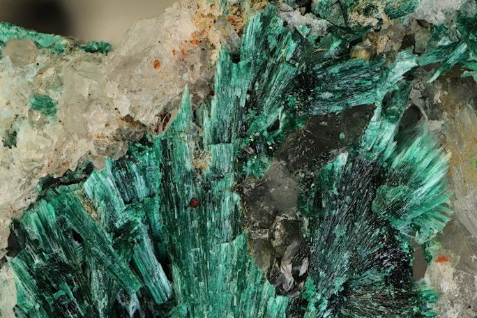


Copperstone Mine, La Paz Mining District, Dome Rock Mountains, La Paz County, Arizona, USA