 | | Journal (article/letter/editorial) |
| crystals, Arkansas also boasts an array of other minerals, as evidenced by this county-by-county description...continued with mining in north ern and western Arkansas and Magnet Cove during the Civil War, and peaked...in full swing and the demand for and price of Arkansas quartz crystals has skyrocketed. In October 1987...exploited. Continued interest in and study of Arkansas minerals, par ticularly the microminerals, will...friends in the Coon Creek Association for their good companionship during my years of Arkansas collecting |
 | | Book |
| Collecting Arkansas JVlinerals A Reference and Guide By Arthur E. Smith, Jr. ,'T Collecting Arkansas...Box 2043 Coeur d’Alene, Idaho 83816-2043 iii Arkansas Counties 1 \ I •( 11 o •« c »««ou cxi ju4«iO«J...573-308-3500 703-648-6045 or phone 800-USA-MAPS Map 3. Arkansas’ Ouachita Mountains 7.5 Minute Quadrangal...Quadrangal Map index. V Contents and Locality Index Arkansas Quartz Crystal Deposits Special Quartz Types....Location 1 Montgomery County quartz deposits................. Other Montgomery County quartz mines...... |
 | | Journal (article/letter/editorial) |
| MINERALS of Arkansas A survey phates of mineral that occur resources in several reveals Arkansas ALBERT...Houston, Texas 77079 My first serious exposure to Arkansas minerals was in the summer of 1948, when I was...assist in a sur vey of the mineral resources of Arkansas. Local landowners and prospectors were encouraged...prospect on Fodderstack Mountain, near Norman, Arkansas, which was further sampled in the field. I recognized...but a common love of Arkansas minerals has met at least once a year as the Coon Creek Mining and Recreational |
 | | Journal (issue) |
| older members who were coming in from all over the USA. Her concern was that upon arrival, they might well...different versions. This version is primarily on his Arkansas experiences and on the naming of kidwellite. Why...talk, and tonight the entire thrust will concern Arkansas. I grew up in the southeast corner of Missouri...Missouri which by all rights should have been Arkansas. The story goes that when the boundary line was to be...not live in Arkansas, so they drew the line around her. My first mineral trip to Arkansas was in 1934 |
 | | Report (issue) |
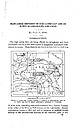
| DEPOSITS OF THE CADDO GAP AND DE QUEEN QUADRANGLES, ARKANSAS. By HUGH D. MISER. INTRODUCTION. The high prices...little-exploited manganese deposits of westcentral Arkansas. These deposits are found at intervals in a belt...quadrangles, Arkansas and Oklahoma. 12 miles wide, extending west-southwestward from Pulaski County, at the...the center of the State, to Polk County, on the west border. Eecent exploitation, begun in 1915 and still...Caddo Gap and De Queen quadrangles, in western Arkansas. The location of the mountainous districts of |
 | | Journal (article/letter/editorial) |
| during the past twenty years than the --------Arkansas Magnet Cove locality. - - - - - - - - Minerals...Vanadium Mines POTASH SULPHUR SPRINGS, ARKANSAS J. MICHAEL HOWARD Arkansas Geological Commission 3815 West...Little Rock, Arkansas 72204 DON R. OWENS Earth Science Department University of Arkansas at Little Rock...Rock 2801 South University Little Rock, Arkansas 72204 Unless otherwise noted, all photos by J. Michael...unknown reason, the name Sulphur Creek, the small north-south creek draining the area, was dropped from |
 | | Journal (issue) |
| stibnites from a new Nevada locality, the Murray Mine, not the old Manhattan, but he had only three specimens...clear calcites from a small pocket in the Meikle Mine, the new locality for the superb yellow barites...specimens of azurite and malachite from the Flambau Mine in Wisconsin, now completely gone, of the chalcocite...News, P.O. Box 2043, Coeur d'Alene, ID 83816-2043 USA Phone: 208-664-2448 E-mail: lream@comtch.iea.com...http://www.iea.com/-lream Web address change for Arkansas site A few months ago, the Mineral News ran a |
 | | Other Paper |
| MAGNET COVE, HOT SPRING COUNTY, ARKANSAS: COLLECTOR AND PROFESSIONAL OBSERVATIONS, STORIES AND PHOTOGRAPHS...Michael Howard MAGNET COVE, HOT SPRING COUNTY, ARKANSAS: COLLECTOR AND PROFESSIONAL OBSERVATIONS,...Michael Howard 16001 Vimy Woods Road Mabelvale, Arkansas 72103 E-mail: jmichaelhoward@sbcglobal.net ©...……………... 38 Christy Brookite Deposit (Vanadium Mine)………………………… 38 Old Highway Outcrops………………………………………………...Kimzey Magnetite Mine (Pit) and Surrounding Area………………………... 44 Chamberlain Creek Barite Mine…………………………………………… |
 | | Book (volume) |
| ...........................................19 Arkansas ..................................................467 Appendix D - The Various names & Forms of Opal .......................................473 Appendix...rights, so remember you were told. If in doubt, a county map will tell you who the legal owner is. Good...gemmy qualities for cutting and polishing. AUTAUGA COUNTY PRATTVILLE, N. 6 mi., and just E of the Birmingham...were well known to prehistoric Indians.) BARBOUR COUNTY BAKER HILL, SE 1 mi. : 1 in a deep ravine, as a |
 | | Book (volume) |
| ...........................................19 Arkansas ..................................................469 Appendix D - The Various names & Forms of Opal .......................................475 Appendix...rights, so remember you were told. If in doubt, a county map will tell you who the legal owner is. Good...gemmy qualities for cutting and polishing. AUTAUGA COUNTY PRATTVILLE, N. 6 mi., and just E of the Birmingham...were well known to prehistoric Indians.) BARBOUR COUNTY BAKER HILL, SE 1 mi. : 1 in a deep ravine, as a |
 | | Journal (issue) |
| previously-reported minerals. CRISM has spotted hydrated silica (opal or volcanic glass). muscovite or illite, and additional...kaolinite is found (Table l ). The hydrated silica (opal) is characterized by broad absorption bands near...3114 El Dorado Ave. N., Lake Havasu City, AZ 86403, USA, and includes CD, pamphlet, and annual updates beginning...the Merced River and its tributaries in .1aripo a County. Results: gold. gold, gold, everywhere, nothing... Mexico and several cadmium smithsonites from Arkansas. Leonard Himes had a great selection of North |
 | | Report (volume) |
| ............................................. Arkansas.................................................mineralogic reports, especially from those of Arkansas, California, Colorado, New Mexico, Oregon, South...examination of the geology of western central Arkansas: Arkansas Geol. Survey Ann. Kept, for 1888, vol. 1...J. C., The zinc and lead region of north Arkansas: Arkansas Geol. Survey Ann. Kept, for 1892, vol. 5...relative to the economic-geologic products of Arkansas, prepared for the Southern Commercial Congress |
 | | Book (volume) |
| ...........................................22 Arkansas ...............................................................548 Table of Maps Page Alabama County Map ...................................................................................4 Alaska County and Stream Map ......................................................................22 Arizona County Map .............................................................42 Arizona – Yavapia Co. Burro Creek area Site Map ................................. |
 | | Journal (issue) |
| phosphate minerals from Mauldin Mountain, Montgomery County, A rkansas.......................................outcrops. In 1877, J. Feeney, a stockman on Yarrow Creek Station (which encompassed the Kingsgate deposits)...mo u t h mineral on the surface near the old tin mine. His curiosity aroused, Feeney sent the specimen...took samples to W. H. Yates, who operated a tin mine on the Severn River near Raid Knob. Yates immediately...molybdenite was saved; most was discarded in the mine dumps or treatment plant residues where it remains |
 | | Journal (article/letter/editorial) |
| Mountain Syenite PULASKI AND SALINE COUNTIES, ARKANSAS Within the last few years, several new occurrences...HENRY L . BARWOOD Arkansas Mining and Mineral Resources Research Institute Arkansas Tech University Russellville...Russellville, Arkansas 72801 A C O M P L E X P L U T O N of medium- to coarse-grained, gray and brown...Saline County to the city limits of Little Rock in Pulaski County. The outcrops in Saline County are weath...ites—has been known since at least 1842 in Pulaski County 314 ROCKS & MINERALS (Williams, 1891). Quarrying |
 | | Report (volume) |
| Alabama.........Dr. Eugene A. Smith, University. Arkansas..........Dr. A. H. Purdue, Nashville, Tenn. California...See Bauxite and Hallpysite. Asbestos. Tallapoosa County, with corundum deposits near Dudleyville; not found...commercial quantity or quality. Asphalt. Colbert County, small quantity has been shipped from near Leighton;...following localities: Bibb County, Pratts Ferry; Calhoun County, near Tampa; Clay County, T. 20, Pv. 7 E.; Jefferson...Jefferson County, at Elyton; Lee County, at Chewacla lime works; St. Clair County, at Gfeensport; Shelby |
 | | Report (edition) |
| STATE OF ARKANSAS BULLETIN 23 MINERAL SPECIES OF ARKANSAS A DIGEST By J. Michael Howard 1987 Revised...Little Rock ARKANSAS GEOLOGICAL COMMISSION Norman F. Williams State Geologist STATE OF ARKANSAS BULLETIN...SPECIES OF ARKANSAS A DIGEST By J. Michael Howard 1987 Revised 2007 Little Rock ARKANSAS GEOLOGICAL...Williams State Geologist STATE OF ARKANSAS Bill Clinton, Governor ARKANSAS GEOLOGICAL COMMISSION Norman F...Magnet Cove areas of Arkansas. The trip was conducted by Mike Howard of the Arkansas Geological Commission |
 | | Report (edition) |
| STATE OF ARKANSAS BULLETIN 23 S P EC I ES O F A RKA N SA A DIGEST By J. Michael Howard \ 1987... / ARKANSAS GEOLOGICAL COMMISSION Norman F. Williams State Geologist s·' , STATE OF ARKANSAS BULLETIN...23 SPECIES OF ARKANSAS A DIGEST By J. Michael Howard 1987 Little Rock ARKANSAS GEOLOGICAL COMMISSION...State Geologist STATE OF ARKANSAS Bill Clinton, Governor ARKANSAS GEOLOGICAL COMMISSION Norman...Magnet Cove areas of Arkansas. The trip was conducted by Mike Howard of the Arkansas Geological Commission |
 | | Journal (issue) |
| Newsletter $3.00 A Quick and Short Collecting Trip to Arkansas in April 2004 Art Smith artsmithite@msn.com Having...Having missed this past fall's Coon Creek trip to Arkansas I was chomping at the bit to get up there...Lake Greeson that is just north of Murfreesboro, Arkansas. He had already examined and collected on the...(Continues on page~-z) Grand Canyon Uranium: The Orphan Mine Dr. Vivien Gornitz vgornitz@giss.nasa.gov Better...deposit was the Orphan Lode (later renamed the Orphan Mine), located on the south rim of the Grand Canyon, |
 | | Book |
| Dinosaur-Capitalsaurus fo, Fossil-Petrified Wood * Arkansas Gem-Diamond * Florida Gem-Moonstone Stone-Agatized...Metal-Silver Precious Gemstone-Virgin Valley Black Fire Opal Semiprecious Gemstone-Iurquoise Rock-Sandstone Soil-Orovada...made the “Magic City” of Birmingham, Jefferson County “The Pittsburgh of the South” during the turn of...feet thick, occurs near Sylacauga, in Talladega County, being fine-grained and mostly white, ofexceptional...white Sylacauga marble from Sylacauga, Talladega County, is considered among the finest white marble in |
 | | Journal (article/letter/editorial) |
| Society produced fossil shells, brown moss agate, and opal shell in matrix, which is said to be wonderful tumbling...shows the story of a diamond from the South African mine, through all the steps in cutting and polishing...especially those found in the Coon Creek area. A Field Trip to the Coon Creek fossil area was a follow up...enjoyed a Field Trip to the Harris Mica Mine in Hanover County. A beautiful clear moonstone is found at...bound volume of a complete set of maps of every county of Virginia. A slide program narrated by Dick May |
 | | Report (volume) |
| Point, 4^ miles south-southeast of the mouth of Coon Creek. PLATE 12 RESOURCES OP THE GASQUET QUADRANGLE...two minor breaks from the type locality on Cow Creek, Oreg., southward to the Gasquet quadrangle. Although...volcanic rocks in the Patrick Creek-Shelley Creek area and the Craigs Creek-Coon Creek area are probably the...best seen on polished, water-worn exposures in creek beds. The rock consists of a heterogeneous mass...Craigs Creek and its tributaries and in excellent exposures along the West Fork of Shelley Creek; at the |
 | | Report (issue) |
| or any other cultural features (city, village, county, township, crossroad, and railroad siding) are...kinds of flowing water that locally may be called a creek, run, river, branch, bayou, or fork. See page XXIV...appropriate variants. County (fourth column) This column lists the name of the county in which the entity... feature, or area lies in more than one county, the county listed is the one in which the center of...in the case of a stream, valley, or arroyo, the county listed is the one in which the mouth of the feature |
 | | Book |
| Readings 88 Index 91 3 63 ILLUSTRATIONS Fall Creek FaJls ji·ont cover Relief map of geologic formations...from the south 15 Exposure of loess in Madison County 16 Kentucky Lake 23 Examples of unconformities...Iron-bearing limonite 33 Great Western Furnace, Stewart County Yearlings grazing on bluegrass 38 Short Mountain...were forrned at the same time on the Missouri-Arkansas side of the river. Perhaps even more curious are...scene is laid not at Loch Ness but at Coon Creek, in McNairy County, one of the most famous fossil -collecting |
 | | Book (edition) |
| thickness; mmed at Broken Arrow aud Trout creek, in Sc. Clair county. The strata in this field are more faulted...south prong of Canoe creek, in St. Clair county, to Ha\sop creek, in Bibb county, a distance of 60 miles...miles. Down to Helena, in Shelby county, the field has an average width of 5 or 6 miles. Below that point...miles being in the latitud" of Blocton, in Bibb county. The south ern end of this field has a greater...Jefferson county; Helena, Montevallo, and Brierfield, Shelby county; and at Blocion. Bibb county. The Warrior |


