Oued el Hamma, El Hamma, Gabès, Tunisiai
| Regional Level Types | |
|---|---|
| Oued el Hamma | - not defined - |
| El Hamma | - not defined - |
| Gabès | Governorate |
| Tunisia | Country |
This page is currently not sponsored. Click here to sponsor this page.


Latitude & Longitude (WGS84):
33° North , 9° East (est.)
Estimate based on other nearby localities or region boundaries.
Margin of Error:
~68km
Köppen climate type:
Mindat Locality ID:
264044
Long-form identifier:
mindat:1:2:264044:3
GUID (UUID V4):
3fb6656a-d2b4-4642-b4ec-d2c020e36d95
Name(s) in local language(s):
Oued el Hamma
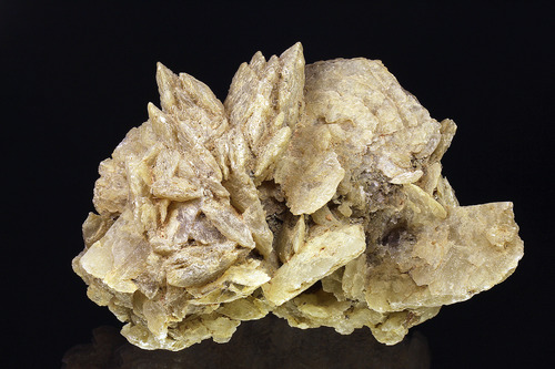
Oued el Hamma is a small creek crossing the road P16 from Gabes to Kebili. Few kilometers west of the village of El Hamma are several outcrops of Gypsum. During a visit in 1996 we also observed some flint tools from neolithic time like arrowheads.
Select Mineral List Type
Standard Detailed Gallery Strunz Chemical Elements
List of minerals arranged by Strunz 10th Edition classification
| Group 7 - Sulphates, Chromates, Molybdates and Tungstates | |||
|---|---|---|---|
| ⓘ | Gypsum | 7.CD.40 | CaSO4 · 2H2O |
List of minerals for each chemical element
| H | Hydrogen | |
|---|---|---|
| H | ⓘ Gypsum | CaSO4 · 2H2O |
| O | Oxygen | |
| O | ⓘ Gypsum | CaSO4 · 2H2O |
| S | Sulfur | |
| S | ⓘ Gypsum | CaSO4 · 2H2O |
| Ca | Calcium | |
| Ca | ⓘ Gypsum | CaSO4 · 2H2O |
Other Regions, Features and Areas containing this locality
This page contains all mineral locality references listed on mindat.org. This does not claim to be a complete list. If you know of more minerals from this site, please register so you can add to our database. This locality information is for reference purposes only. You should never attempt to
visit any sites listed in mindat.org without first ensuring that you have the permission of the land and/or mineral rights holders
for access and that you are aware of all safety precautions necessary.


Oued el Hamma, El Hamma, Gabès, Tunisia