Kohl’s Ranch fossil locality, Gila County, Arizona, USAi
| Regional Level Types | |
|---|---|
| Kohl’s Ranch fossil locality | Paleontological Locality (Paleo feature) |
| Gila County | County |
| Arizona | State |
| USA | Country |
This page is currently not sponsored. Click here to sponsor this page.


Latitude & Longitude (WGS84):
34° 19' 19'' North , 111° 6' 39'' West
Latitude & Longitude (decimal):
Type:
Paleontological Locality (Paleo feature) - last checked 2021
Age:
315 to 300 Ma
Geologic Time:
Köppen climate type:
Nearest Settlements:
| Place | Population | Distance |
|---|---|---|
| Tonto Village | 256 (2011) | 2.0km |
| Christopher Creek | 156 (2011) | 8.7km |
| Star Valley | 2,277 (2017) | 15.5km |
| Whispering Pines | 148 (2011) | 16.7km |
| Mesa del Caballo | 765 (2011) | 17.4km |
Mindat Locality ID:
213149
Long-form identifier:
mindat:1:2:213149:1
GUID (UUID V4):
0d01c54c-200c-4346-b53d-c88d591273d5
Other/historical names associated with this locality:
Kohl Ranch; Kohls Ranch; Paleo site; Indian Gardens Paleo Site
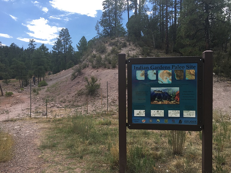
A fossil occurrence/site centered about 1.6 km (1 mile) west of Kohl’s Ranch. The site extends along, and a short distance from, the new and old alignments of State Highway 260 from the intersection of Forest Road (FR) 64 in the west to Indian Gardens in the east. The main Kohl’s Ranch site in the center of the area is now buried under a new alignment of Highway 260. A new site, the Indian Gardens Paleo Site, was placed on the Kohl’s Ranch site. It was created and signed with the help of Ben Mohler as an Eagle Scout project.
Primarily a fossil collecting site in limestone and shale of the Middle Pennsylvanian beta member of the Naco Formation. This is one of the most prolific, important and well-studied Pennsylvanian fossil sites in Arizona that has been visited by countless grade school through college students.
Select Mineral List Type
Standard Detailed Gallery Strunz Chemical ElementsCommodity List
This is a list of exploitable or exploited mineral commodities recorded at this locality.Mineral List
1 valid mineral.
Rock Types Recorded
Note: data is currently VERY limited. Please bear with us while we work towards adding this information!
Select Rock List Type
Alphabetical List Tree Diagram
List of minerals arranged by Strunz 10th Edition classification
| Group 4 - Oxides and Hydroxides | |||
|---|---|---|---|
| ⓘ | Quartz var. Agate | 4.DA.05 | SiO2 |
| ⓘ | 4.DA.05 | SiO2 | |
| Unclassified | |||
| ⓘ | 'Jasper' | - | |
Other Regions, Features and Areas containing this locality
North America PlateTectonic Plate
- Great Plains DomainDomain
USA
- Arizona
- Tonto National ForestForest
- Colorado PlateauPlateau
This page contains all mineral locality references listed on mindat.org. This does not claim to be a complete list. If you know of more minerals from this site, please register so you can add to our database. This locality information is for reference purposes only. You should never attempt to
visit any sites listed in mindat.org without first ensuring that you have the permission of the land and/or mineral rights holders
for access and that you are aware of all safety precautions necessary.
References
www.kickstarter.com (n.d.) https://www.kickstarter.com/projects/2146434805/mohler-eagle-project-paleo-site-fossil-interpretiv/posts/1586398
azmemory.azlibrary.gov (n.d.) https://azmemory.azlibrary.gov/digital/api/collection/statepubs/id/29279/download
fossilworks.org (n.d.) http://fossilworks.org/bridge.pl?a=collectionSearch&collection_no=90772&is_real_user=1
Webster, Gary D., Olson, Thomas J. (1998) Nacocrinus elliotti, a new pachylocrinid from the Naco Formation (Pennsylvanian, Desmoinesian) of central Arizona. Journal of Paleontology, 72 (3) 510-512 doi:10.1017/s0022336000024288
Lundin, Robert F., Sumrall, Colin D. (1999) Ostracodes from the Naco Formation (Upper Carboniferous) at the Kohl Ranch locality, central Arizona. Journal of Paleontology, 73 (3) 454-460 doi:10.1017/s0022336000027979


Kohl’s Ranch fossil locality, Gila County, Arizona, USA