| Locality | Latitude | Longitude | Distance | Bearing |
|---|
| Niagara No. 1 Reserve St-11 Prospect, St. Louis County, Minnesota, USA | 47° 25' 56" N | 92° 56' 58" W | 1.1km (0.7 miles) | |
| Rust Reserve P-32 Prospect (Syracuse Mining Company; P-M & Company Agt), St. Louis County, Minnesota, USA | 47° 26' 16" N | 92° 56' 39" W | 1.3km (0.8 miles) | |
| Agnew No. 3 Reserve X-41 Prospect, St. Louis County, Minnesota, USA | 47° 26' 20" N | 92° 56' 7" W | 1.3km (0.8 miles) | |
| Scranton Mine (Elizabeth Mine; State of Minnesota), St. Louis County, Minnesota, USA | 47° 26' 26" N | 92° 56' 31" W | 1.5km (1.0 miles) | |
| Burrall Reserve X-44 Prospect (Meriden Engineering), St. Louis County, Minnesota, USA | 47° 26' 25" N | 92° 55' 27" W | 1.8km (1.1 miles) | |
| U.S. Steel Reserve O-56 Prospect (U S Steel Corp), St. Louis County, Minnesota, USA | 47° 26' 26" N | 92° 55' 26" W | 1.8km (1.1 miles) | |
| Southern Townsite Reserve P-31 Prospect (Syracuse Mining Company; P-M & Company Agt), St. Louis County, Minnesota, USA | 47° 26' 40" N | 92° 56' 16" W | 2.0km (1.2 miles) | |
| Boeing Mine (Hanna Mining Company; Hanna Mining Company Agt), St. Louis County, Minnesota, USA | 47° 26' 38" N | 92° 55' 41" W | 2.0km (1.2 miles) | |
| Agnew No. 2 Mine (P-M & Company Agt; Syracuse Mining Company), St. Louis County, Minnesota, USA | 47° 25' 50" N | 92° 57' 51" W | 2.0km (1.3 miles) | |
| Iron Range Reserve O-90 prospect (U S Steel Corp), St. Louis County, Minnesota, USA | 47° 26' 20" N | 92° 54' 59" W | 2.1km (1.3 miles) | |
| South Rust Mine (Syracuse Mining Company; P-M & Company Agt), St. Louis County, Minnesota, USA | 47° 26' 44" N | 92° 56' 48" W | 2.2km (1.4 miles) | |
| Alworth Land Mine (Hanna Mining Company; Hanna Mining Company Agt), St. Louis County, Minnesota, USA | 47° 26' 30" N | 92° 57' 29" W | 2.2km (1.4 miles) | |
| Pierce Group Mine (Impro A Mine; Impro B Reserve; Roy Mine; Norpac Mine), St. Louis County, Minnesota, USA | 47° 26' 48" N | 92° 57' 7" W | 2.4km (1.5 miles) | |
| North Eddy Mine (Agnew; So. Agnew), St. Louis County, Minnesota, USA | 47° 26' 15" N | 92° 58' 0" W | 2.5km (1.5 miles) | |
| South Agnew Mine (Syracuse Mining Company; P-M & Company Agt), St. Louis County, Minnesota, USA | 47° 26' 15" N | 92° 58' 1" W | 2.5km (1.6 miles) | |
| Susquehanna Mine (Buffalo-Susquehanna Mine; Anna Mining Company Agt; Hanna Ore Mining Company), St. Louis County, Minnesota, USA | 47° 26' 57" N | 92° 55' 53" W | 2.5km (1.6 miles) | |
| Agnew Mine (Syracuse Mining Company; P-M & Company Agt), St. Louis County, Minnesota, USA | 47° 26' 31" N | 92° 57' 51" W | 2.6km (1.6 miles) | |
| Gray Annex Reserve G-8, St. Louis County, Minnesota, USA | 47° 25' 50" N | 92° 58' 19" W | 2.6km (1.6 miles) | |
| Penobscot Mine (U S Steel Corp), St. Louis County, Minnesota, USA | 47° 26' 53" N | 92° 57' 20" W | 2.7km (1.7 miles) | |
| Gray Reserve St-6 (State of Minnesota), St. Louis County, Minnesota, USA | 47° 25' 37" N | 92° 58' 27" W | 2.8km (1.7 miles) | |
| Weggum Mine (Philbin Mine; State of Minnesota), St. Louis County, Minnesota, USA | 47° 26' 54" N | 92° 55' 8" W | 2.8km (1.7 miles) | |
| Webb Mine, St. Louis County, Minnesota, USA | 47° 27' 2" N | 92° 55' 31" W | 2.8km (1.7 miles) | |
| North Eddy Mine (Eddy Mine), St. Louis County, Minnesota, USA | 47° 26' 15" N | 92° 58' 18" W | 2.8km (1.8 miles) | |
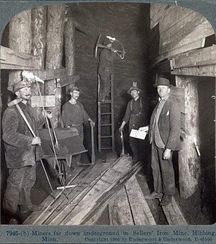
| Sellers Mine (Sellers Triangle Mine; Rhude & Fryberger Inc), St. Louis County, Minnesota, USA | 47° 27' 11" N | 92° 56' 11" W | 2.9km (1.8 miles) | |
| South Longyear Mine, St. Louis County, Minnesota, USA | 47° 27' 2" N | 92° 55' 9" W | 2.9km (1.8 miles) | |
| South Longyear Mine (Hanna Mining Company Agt; Hanna Ore Mining Company), St. Louis County, Minnesota, USA | 47° 27' 6" N | 92° 55' 12" W | 3.0km (1.9 miles) | |
| South Eddy Mine (Eddy Mine; Inland Steel Company), St. Louis County, Minnesota, USA | 47° 25' 58" N | 92° 58' 39" W | 3.1km (1.9 miles) | |
| Utica Mine, Mesabi Range, St. Louis County, Minnesota, USA | 47° 26' 13" N | 92° 58' 32" W | 3.1km (1.9 miles) | |
| Utica Mine (Hanna Mining Company; Hanna Mining Company Agt), St. Louis County, Minnesota, USA | 47° 26' 33" N | 92° 58' 18" W | 3.1km (1.9 miles) | |
| Rust Mine, Mahoning-Hull-Rust Mine, Hibbing, St. Louis County, Minnesota, USA | 47° 27' 11" N | 92° 57' 11" W | 3.1km (1.9 miles) | |
Minerals recorded nearby (within 3.1 km)
Rock types recorded nearby (within 3.1 km)
Entries shown in red are rocks recorded for this region.


Sellers Mine, St. Louis County, Minnesota, USA