 | | Report (issue) | | 0, I y. 50 .r rVv, rv O. ^ NORTH CAROLINA DEPARTMENT OF CONSERVATION AND DEVELOPMENT R. BRUCE ETHERIDGE...BULLETIN NO. 50 The Vermiculite Deposits of North Carolina BY THOMAS G. MURDOCK AND CHARLES E. HUNTER...UNDER THE DIRECTION OF JASPER L. STUCKEY, NORTH CAROLINA DEPARTMENT OF CONSERVATION AND DEVELOPMENT...TENNESSEE VALLEY AUTHORITY RALEIGH 1946 NORTH CAROLINA DEPARTMENT OF CONSERVATION AND DEVELOPMENT...BULLETIN NO. 50 The Vermiculite Deposits of North Carolina BY THOMAS G. MURDOCK AND CHARLES E. HUNTER |  | | Report (volume) | | Knoxville 1 °X2° Quadrangle, Tennessee, North Carolina, and South Carolina U.S. GEOLOGICAL SURVEY BULLETIN...Knoxville 1°X2° Quadrangle, Tennessee, North Carolina, and South Carolina By G.R. ROBINSON, Jr., F.G. LESURE...Knoxville 1°X2° quadrangle Tennessee, North Carolina, and South Carolina I by G.R. Robinson, Jr. ... [et al...Geology- Tennessee. 2. Geology-North Carolina. 3. Geology-South Carolina. 4. Mines and mineral resources-...and mineral resources-North Carolina. 6. Mines and mineral resourcesSouth Carolina. I. Robinson, G.R. II |  | | Journal (article/letter/editorial) | | impounded glacier-lakes suggested the operation of Lake District rather than Galloway or Southern Upland...and the drift. To cite but one example: although Lake District erratics, principally lavas and ashes of...Volcanic Series, predominated in the drift, suggesting Lake District ice moving down Edenside, yet the drift...universally accepted view of the glaciation of the North of England, it was decided forthwith to accumulate...and it was decided to divide Eden~ide into two districts--the River Eden to be his eastern and my western |  | | Report (volume) | | Carbonaceous quartzite________________________________ Quartz-sericite-chlorite phyllite._________________________...____ Sericite-quartz-chlorite-albite schist and phyllite,_________ Carbonaceous quartz-sericite-chlorite..._______________ Quartz-sericite-albite-chlorite granulite___________________ Quartz-sericite-chlorite...Mountain formation._________________________________ Quartz conglomerate.__________________________________...TABLE 1. Correlation of the rock formations of north-central Vermont and adjacent Quebec______---___ |  | Carlsen, Kenneth S., Gale, Marjorie H., Thompson, Woodrow B., Kierstead, Matthew (2015) Belvidere Mountain Asbestos Quarries, Lowell/Eden, Vermont. Rocks & Minerals, 90 (6) 510-551 doi:10.1080/00357529.2015.1080535 | Journal (article/letter/editorial) | | aerial view of the Ruberoid Corporation Asbestos mine, ca. 1960. Frank L. Forward photo. A Belvidere...engine and ore cars made only two passes between North Hyde Park and the Gallagher quarry because it broke...William Besse. B elvidere Mountain, Quarries Lowell/Eden, Vermont in northern Vermont, is known to generations...postcard of the initial three-story mill at the Eden mine that opened in May 1902 but closed later in the... we and our colleagues, being familiar with the mine, decided that it is important to document this famous |  | | Report (issue) | | adjoining areas 78 1 l.-Measured Section half a mile north-east of.Knarsdale Church in the east bank of the...rith Sandstone along the left bank of the River Eden half a mile south of Hornsby 128 17.-Ivlap showing...No. 4138) 1 View of country north of the Roman Wall, ll miles · north-east of Greenhead (Survey Photograph...Northumberland-Durham Coalfield . . . 99 Whin dyke, north side of the South Tyne, a quarter of a mile south-east...Sill, \Valltown Quarry, three quarters of a mile north-east of Greenhead Station (Survey Photograph No |  | | Report (issue) | | 265 Tripoli and rottenstone__ __ _____ ___ __ 266 Quartz abrasives____________________ 266 Artificial a...____ Districts in Appalachia__________________ North Carolina_____________________ South Carolina_____________________...___________ Ne~ 1:ork_________________________ North Carolina__ _ ________ __ ______ __ Ohio________...sulfides____________________________ Sulfide-bearing quartz veins__________ Native copper deposits __________...Georgia_________________ Deposits in North Carolina__________ Deposits in South Carolina and Virginia____________________________ | 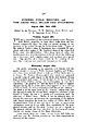 | | Journal (article/letter/editorial) | | halt-stages, at the margin of the ice which lay in the Eden Valley, during the retreat-phase of the Main Glaciation...Beds, all seen in the River Belah 3 miles to the north, furnished evidence of the irregular surface upon...itself is mineralized and is the site of an old lead mine whose tip heaps were examined. Mr. Shotton expressed...south, in accord with the overturning which occurs north of the fault. Mineralization of the fault followed...Middle Limestone Group, dipping upstream (i.e., north-eastward) at ever-decreasing angles, until on the |  | | Journal (article/letter/editorial) | | or adjacent to diabase dikes (11 cases); in (quartz, quartz--carbonate) veins (85 cases); stratiform (25...7% in the Quirke Lake Group, 24.9% in the Hough Lake Group and 9% in the EUiott Lake Group. Frequency...the east of the well known uranium camps of Elliot Lake and Blind River; in particular, they appear concentrated...understood. It has long been known from the Elliot Lake ores, although it has evidently n o t been considered...although, with the exception of those in the Montgomery Lake-Padlei area of the Northwest Territories (Roscoe |  | Salnikova, Ekaterina B., Chakhmouradian, Anton R., Stifeeva, Maria V., Reguir, Ekaterina P., Kotov, Alexander B., Gritsenko, Yulia D., Nikiforov, Anatoly V. (2019) Calcic garnets as a geochronological and petrogenetic tool applicable to a wide variety of rocks. Lithos, 338. 141-154 doi:10.1016/j.lithos.2019.03.032 | Journal (article/letter/editorial) | | from Neoarchean to Permian-Triassic (Cinder Lake and Eden Lake in Manitoba, Canada; Belaya Zima and Odikhincha...well-characterized Neoarchean material from the Cinder SC Lake complex in Manitoba, Canada (Chakhmouradian et al...further in AC C Section 5. 3.1. Cinder Lake The Cinder Lake alkaline intrusive complex (eastern Manitoba...located in the central part of the Neoarchean Gods Lake Domain (GLD), a large greenstone-granite belt in...Neoarchean (~2.7 Ga) collision zone between the North Caribou and North Superior microcontinents (Lin et al., 2006; |  | | Journal (article/letter/editorial) | | along much of the distance between Georgian Bay and Lake Nipissing (Fig. 1). My intention is to show Fig...Paleoproterozoic plutons: KL= Killarney, EL=Eden Lake, CL=Chief Lake, FI=Fox Islands, GR=Grondine, KH=Key Harbour...Mesoproterozoic plutons: BL=Bell Lake, SF=Sturgeon Falls, WBN=West Bay (north), WBS=West Bay (south); see...(1975) mapped the area east of 81° longitude and north of 46° latitude (Fig. 1). He also classified most...Fig. 1. They include the Chief Lake, Eden Lake and Killarney plutons north of the Grenville Front; the Fox |  | | Report (volume) | | for the convergence of level planes toward the north have been adjusted to remove accidental closure...[Latitude 44°45'-450;«longitude 71°30'-71°45'] ESSEX COUNTY From Island Pond quadrangle east along Grand Trunk...Hampshire. »A narrow strip of territory lying just north of latitude 45°, given as the northern u'mit of...washer___________________________.__ 1, 746. 33 Forest Lake, on N. side of, 1.8 mi. SE. of Averill post office...Camp on W. side of lake, on top of large boulder; chiseled square.______ Forest Lake; surface of water |  | | Report (volume) | | .................................... 203 North Carolina..................................................................................... South Carolina.................................................WHITNEY. Barometric determinations from the report on Lake Superior mining: region. FREMONT, CAPT. JV C. Barometric...the tl Virginias." Profiles of most of the North Carolina roads have been published in the report of...have been obtained. The work of the United States Lake Survey in determining the heights of the Great Lakes |  | | Report (issue) | | GEOLOGY OF THE BELVIDERE MOUNTAIN COMPLEX, EDEN AND LOWELL, VERMONT by Marjorie Hollis Gale U.S. Geological................. Calcite ....................... Quartz ................'........ Biotite ............................. Biotite ....................... Quartz ........................ Opaques .............................. Garnet ........................ Quartz ........................ Biotite ................I. II. GEOLOGY OF THE BELVIDERE MOUNTAIN AREA, EDEN AND LOWELL, VERMONT .............. INDEX MAP . |  | | Report (issue) | | rest of the name: Adams, Mount Ann, Lake Saint Louis, Bay Woods, Lake of the. Definite-form names also are...or any other cultural features (city, village, county, township, crossroad, and railroad siding) are...appropriate variants. County (fourth column) This column lists the name of the county in which the entity...place, feature, or area lies in more than one county, the county listed is the one in which the center of...in the case of a stream, valley, or arroyo, the county listed is the one in which the mouth of the feature |  | | Report (issue) | | Data, 1997 through 1999, for the Lake Traverse Reservation/Roberts County Water-Resources Investigation...Survey, Sisseton-Wahpeton Sioux Tribe, and Roberts County U.S. Department of the Interior Bruce Babbitt...11 -20. Hydrographs for lakes: 11. Bitter Lake in Day County....................................................................... 12. Blue Dog Lake in Day County ........................................................... 13. Buffalo Lakes in Marshall County............................................... |  | Nagy, B., Weber, R., Guerrero, J. C., Schidlowski, M. - Eds. (1983) Developments in Precambrian Geology - Developments and Interactions of the Precambrian Atmosphere, Lithosphere and Biosphere, Compilation of papers based on the presentations of participants at, or contributed by authors unable to attend, the IGCP Projects 157 and 160 meeting at the Universidad Nacional Autonoma de Mexico in Mexico City - Developments in Precambrian Geology No. 7. Elsevier. doi:10.1016/s0166-2635(08)x7011-2 | Book | | 1980. Origin of uraniferous conglomerates at Elliot Lake, Canada and Witwatersrand, South Africa: implications... J.W.H. and Klug, M.J., 1979. Methane flux from lake sediments through water lilies. Science, 203: 1253-1255...T., Harvey, G.R. and Rubin, M., 1973. Methane in Lake Kivu: new data bearing on its origin. Science, 181:...257 pp. Koyama, T., 1963. Gaseous metabolism in lake sediments and paddy soils and the production of...1980. Stromatolites 3,400-3,500 Myr old from the North Pole era, Western Australia. Nature, 284: 443-445 |  | | Report (issue) | | Slates es Horizontal section in Skiddaw Slates on north-south line through Fic. Horizontal Fic. Fic....feldspathic and ferromagnesian rich bands, 1000 yd north-west of Mosedale. Pirate V A The view shows characteristic...(1929-32) (1922-6) (1931) 55.N.E. Bassenthwaite Lake 57N.W. Mungrisdale 56.N.W. 56N.E. 57 N.E. Bassenthwaite...(1931-2) (1931-2) (1930-2) (1930-2) The Cumberland County Six-inch Sheets of the Ordnance Survey ha ve now...Grid Sheets, In due course the geological Six-inch County Sheets will be ré-constituted as National Grid | | | Report (issue) | | on north-south line through Whitefield House .. 35 Horizontal section in Skiddaw Slates on north-south...feldspathic and ferromagnesian rich bands, 1000yd north-west of Mosedale. The view shows characteristic...(1929-31) (1929-32) (1922-6) (1931) X Bassenthwaite Lake .. 55 N.E. .. 56 N.W. Bassenthwaite Common 56 N.... .. 57 N.E. Berrier and Murrah The Cumberland County Six-inch Sheets of replaced by National Grid Sheets...Ordnance Survey have now been the geological Six-inch County Sheets Chapter I INTRODUCTION THE DISTRicr1 |  | | Report (issue) | | ......12 Stratigraphic units related to glacial Lake Agassiz.......................................................................................18 NORTH KNIFE RIVER SECTIONS: INTERLOBATE ZONES, SHIFTING..................................19 SECTIONS NORTH OF NORTH KNIFE RIVER: KEEWATIN ICE FLOW . ........................................................21 North area..............................................IN THE LYNN LAKE AREA .......................22 iii Summary of events in the Lynn Lake–Leaf Rapids |  | | Report (volume) | | Messrs J. B. W. Day and R. H. Price in central and north-western parts of the district respectively, and...by Messrs. D. H. Land and D. A. C. Mills in the north-eastern part. The list of six-inch maps with the...selected horizons in the Upper Border Group in the north-eastern part of the district 136 Flo. 27. Sketch-map...different parts of the district Sketch-map showing a quartz-dolerite dyke off-set at Short Oeugh Sketch of...(excluding the North Tyne District) The Spy Rigg Sandstone, Sundaybum Linn, River lrthing, looking north-eastwards |  | | Book | | Vertical Controls.7 Excavation Procedures (General).9 North Block Studies (Excavation Area I). 11 South Block...Descriptions.L.54 Grid 140-170 N Escarpment and North Block Stratigraphy.56 Escarpment Exposure.56 Excavation...section A-A’ (by J. Albanese). 18. Map of 1995 North Block (Excavation Area I) (by J. Albanese). of...locations of Test Pits/Excavation Areas, South and North Blocks, and grid system. 23. Spatial distribution...4. 5. Stratigraphic section showing West and North Walls of Test Pit/Excavation Area A (D. Batten profile) |
|


