 | | Journal (article/letter/editorial) | | MINERALOGY OF The Granite Mountain Syenite PULASKI AND SALINE COUNTIES, ARKANSAS Within the last few...from the syenite pegmatites of Granite Mountain. HENRY L . BARWOOD Arkansas Mining and Mineral Resources...Resources Research Institute Arkansas Tech University Russellville, Arkansas 72801 A C O M P L E X P L U T O...Saline County to the city limits of Little Rock in Pulaski County. The outcrops in Saline County are weath...the northeast forms a promi nent ridge ("Granite" Mountain) and contains four active and many inactive |  | | Report (issue) | | ________________________ ____________ _ Location of the area ________________________ _ Relief _____________... Ltlhology _____ __________ ______ ________ _ Granite ______________________________ ~ ____ _ Distribution...position and classification __ .. _ Tertiary (?) granite __________________ __ _____ _ Distribution and...Differentiation ______________ ______ ________ _ Rock alteration and its significance ____ -- _____ ___...Alteration in the northern area __ _-' ___ ~ ___ Alteration in the southern area ______ ____ _ Silicification |  | | Journal (article/letter/editorial) | | uranium deposits of the Great Divide Basin, Wyoming, USA M. Z. Abzalov* and O. Paulson The Great Divide basin...in the southern part of the state of Wyoming in USA. Wyoming is the second largest uranium province in...Precambrian rocks including uraniferous Precambrian granite. The main uranium resources of the Great Divide...Wyoming is a second largest uranium province in the USA after the Colorado Plateau (Dahlkamp, 1993). Uranium...western and north western boundaries are marked by the Rock Springs and the Wind River uplifts, respectively |  | | Report (issue) | | the Arkansas Bauxite Region GEOLOGICAL SURVEY PROFESSIONAL PAPER 299 Geology of the Arkansas Bauxite...Director Gordon, Mackenzie, Jr., 1913Geology of the Arkansas bauxite region, by Mackenzie Gordon, Jr., Joshua...Bibliography: p. 256-261. 1. Bauxite. 2. Geology Arkansas. sources Arkansas. (Series) QEY5.P9 no. 299 Copy 2. 3...Rocks of the more deeply buried parts of the Little Rock igneous complex _______________ Structural relationship...mining_______________________ Uses and grades of Arkansas bauxite ______________ Reserves _ ___________ |  | | Report (issue) | | OF THE BENNETT MOUNTAINS WILDERNESS STUDY AREA, CARBON COUNTY, WYOMING By Robert J. Walker ', H. Roberta...of the Bennett Mountains Wilderness Study Area, Carbon County, Wyoming................. 2 Tables Table...mineral potential within the Bennett Mountain Wilderness Study Area.............. Plate 1. Geologic map...of the Bennett Mountains Wilderness Study Area, Carbon County, Wyoming................... In pocket 2....stream-sediment and rock-sample localities from the Bennett Mountains Wilderness Study Area, Wyoming...... |  | | Report (volume) | | Geology of the Curlew Quadrangle Ferry County Washington By RAYMOND L. PARKER and JAMES A. CALKINS GEOLOGICAL...Laurence, 1921Geology of the Curlew quadrangle, Ferry County, Washington, by Raymond L. Parker and James A....1923joint author. II. Title: Curlew quadrangle. Ferry County, Washington. (Series) For sale by the Superintendent...belt...._.._..._.._..___.____.__.._.______ Granite Mountain area________________________________Area north..._____________________'_________________ Klondike Mountain Formation________ ______________________ General |  | | Journal (article/letter/editorial) | | plagioclase,chlorite, epidote, and products of the biotite (chlorite, epidote, and sphene. The sulfur...Precambrian granite and diawith the Ruby Star Granodiorite (named by base and four Laramide intrusive rock types...associatedwith the Ray deposit are prethe Granite Mountain Porphyry (Metz and Rose, sented in Table 1...to locate an exposed main stock of the Granite Mountain area for analysis on an individual biotite grain...chlorite are consideredto be maximum quartzite, granite, and diabase. ones. Sulfur in the biotites probably |  | | Report (issue) | | of the Mahogany zone (Eocene), Cathedral Bluffs area, northwestern Colorado, by J. R. Donnell and A....paleotectonic implications, Blue Range primitive area, Arizona and New Mexico, by E. R. Landis, J. C....of glaciation in the Mesabi-Vermilion Iron Range area, northeastern Minnesota, by T. C. Winter . . . ...Mineralogy Clay minerals, Longfellow mine, San Juan County, Colo., by R. G. Luedke and J. W. Hosterman ......• · · Accessory epidote from hybrid granitoid rocks of the Mount Wheeler mine area, Nevada, by D. E |  | | Report (issue) | | . . . . . . . . . . . . . . . . . . . . . . 1 County Listings. . . . . . . . . . . . . . . . . . . .... . . . . . . . 4 Mineral Localities Listed by County . . . . . . . . . . . . . . . . . . . . . . . .... . . . . . . . . . . . . . . . . . . 7 Beaver County . . . . . . . . . . . . . . . . . . . . . . . ... . . . . . . . . . . . . . . . . . 7 Box Elder County . . . . . . . . . . . . . . . . . . . . . . . .... . . . . . . . . . . . . . . . . . . 10 Cache County . . . . . . . . . . . . . . . . . . . . . . . |  | | Book (edition) | | Co\·er photo: \\ 7 ulfenite, Rowley Mine, Maricopa County, 4 cm high specimen, Evan and Melissa Jones Collection...gemandmineralmuseum.arizona.edu) is located in the old Pima County Courthouse building at 115 North Church Avenue...on the market. The mines at Bisbee, in Cochise County, have produced large quantities of gem-quality...mineral stamp issued in 1992. At Morenci, in Greenlee County, gem-quality azurite was also commercially recovered...parallel to the grain. The Blue Ball Mine, in Gila County, has produced thousands of azurite nodules up to |  | | Report (issue) | | Pee i oh ce bdd hos iad Rad Lakesacdeeerd 94 Steep Rock Lake .ssecececeveescssesssessereressesesveseses...enews: Wieyei aia wave tie"weue'e shetout 266 Bagte Mountain secccccsetee ves eeoee ee eevee ecs ee 268 Engels...no OIL ORO OIG ZoZ 292 Boulder County Tellurides .... 294 Boulder County Tungsten ...... eeoeeesee 296...323 A. Rifle area, Colorado «0s... 323 B. Uravan District, Colorado 324 Cope tick Rock DIsEEIcL sCoLoradO)...Utah ...coccccecccccesece 334 N. San Rafael—Cedar Mountain, Utah .ccccccccccecccscscvce 339 PTA aioktevaaaieal |  | | Book (edition) | | c Quartzsite Gold Atlas Vol. 2 Southern Dome Rock Mountains A comprehensive guide to the history,...distribution of placer and lode gold from the southern Dome Rock Mountains, Arizona Dr. Erik Melchiorre Library...Claims. Back: Cholla Gold Eye Claims, area. Copyright © 2013 by Rock Doc Publications All rights reserved...acasssactee eer tate ate Meee ree 2/ The Towns of Picture Rock, Tysons Well, and Quartzsite Chapter 4 2 ccsasicisisee...ccsasicisisee cnea ae ae etn eee 4] Granite Mountain Area Chapter 5 cats crenta ate suc eee tna eee 87 Sugarloaf |  | | Report (issue) | | Geologic Map of the Julian 7.5' Quadrangle, San Diego County, California By Victoria R. Todd Open-File Report...Geologic map of the Julian 7.5' quadrangle, San Diego County, California: U.S. Geological Survey Open-File Report................................................ 1 Rock Units ....................................................................... 6 Tonalite of Granite Mountain ............................................San Diego County, California ii Geologic Map of the Julian 7.5' Quadrangle, San Diego County, California |  | | Report (issue) | | Copper Deposit and the Kelvin Copper Prospect Pinal County, AZ By Edward John, Russell Com, Richard Ahern...diabase sills and were later intruded by the Granite Mountain porphyry of Laramide age-the probable source...exploration geologists who worked in the Kelvin area and currently control exploration ground there....Geology of the Ray porphyry copper deposit, Pinal County, Arizona Ed John ................................structural cover at the Kelvin porphyry deposit, Pinal County, Arizona Russell M. Corn, Richard Ahern....... |  | | Report (issue) | | North American continent. In the McCall, Idaho, area (fig. 1), the suture zone can be located fairly...metamorphism and structure of rocks in the Riggins, Idaho, area. East of the suture zone, they documented east-vergent...Snee (1988) described (1) vertical transport of rock material at and adjacent to the suture, (2) formation... Moscow Pullman OR WA ID ID S ke na River Area of map He lls Ca Se n v e Mtn n D yon s. evi ls...wisdom of previous geologists working in the SRSZ area. Notable among these are Waldemar Lindgren, Clyde |  | | Report (issue) | | CONTENTS Page Page A. --Sweepstakes Creek area, 1945., by H. R. Gault, R. F. Black,and J. B. Lyons...vicinity . . . . . . . . . 7 CHAPTER B. --Candle Creek area, 1945, by H. R. Gault Abstract. ............•.•...investigation .....................• 15 Location of area ...........••...••... 15 Geology ......•..........Introduction.............................. 21 Location of area ......... ~ ........... 21 Purpose and scope of...Distribution of radioactive minerals ..... 23 Granite Mountain area .......... ,'24 Headwaters of the Peace |  | | Report (volume) | | Early, Middle, and Late, and for epochs. Informal rock terms lower, middle, and upper may be used where...Martha S. Toulmin, and Druid Wilson. The geographic area covered includes the United States, its possessions...administered by the United States. This geographic area is much smaller than that for the Wiln1arth Lexicon...3 and Central America. This smaller ge_ographic area was selected primarily because the International...Genevieve Limestone in Blue River Group" in another area. Finally, the name in boldface indicates that the |  | | Report (issue) | | History of the Iron Industry in Utah · .1 Beaver County . . . . . . . . . . . . .2 Beaver Lake Mountains.... . . . . . . . .2 . . . . . . . . . . .2 Black Rock mine . . . Skylark mine . . . . . . . . . . . ....Mountains deposits . . . . . . . . . . . .11 Blawn Mountain prospects . . . . . . . . . . · ... 11 Iron Queen...13 Wah Wah pass prospects · . . . . 13 Box Elder County . . . . . . . . . . . . . . · .... Pilot Range...deposits . . . . . . . . . . . . . · ... Copper Mountain mine . . . . . . . . . . . . . . . · Tecoma mine |  | | Report (issue) | | ... General character ............... Purcell Mountain pluton ............ Hawk River pluton ..........ROCKS Continued B. ALKALINE ROCKS Continued Granite Mountain pluton .............. 6l General character...Creek pluton ............... 98 101 103 Indian Mountain and Mt. George plutons and related hypabyssal...summary of the Granite Mountain pluton 65 9. Chemical data of the Granite Mountain pluton .... 70...alkaline rocks . 60 18 Plot of modes from Granite Mountain pluton 64- 19 Photograph of pseudoleucite |  | | Report (volume) | | , Fort Knox, Alaska; Dublin Gulch, Yukon; Red Mountain, B.C.) in the northwestern Cordillera offer exciting...syntectonic Gibraltar deposits and end-member gold-rich granite-hosted deposits such as Fort Knox. In Washington...made, as yet, this research appears to have had little impact on exploration. Many significant porphyry...Lornex, Bethlehem, Highmont and JA) within a 15 km? area. The Highland Valley Copper operation, based on...stress regime during the emplacement. The Babine Lake area, another important cluster with two past-producing |  | | Report (issue) | | examines new U-Pb ages for intrusive rocks of the Granite Mountain batholith (Late Triassic) including the Burgess...Mesilinka intrusive suites. Also in the Hogem Batholith area, Ferbey and Elia describe the Late Wisconsinan ice-flow...the Granite Mountain batholith, Burgess Creek stock, and Sheridan Creek stock, Gibraltar Mine area, south-central...surficial geology of the northern Hogem batholith area, north-central British Columbia ..................regional Kitsault, regional Depth-to-bedrock Granite Mountain geochronology Mt. Timothy geochronology Central |  | Peters, S.G., Nash, J.T., John, D.A., Spanski, G.T., King, H.D., Connors, K.A., Moring, B.C., Doebrich, J.L., McGuire, D.J., Albino, G.V., Dunn, V.C., Theodore, T.G., Ludington, S.D. (1996) Metallic mineral resources in the U.S. Bureau of Land Management's Winnemucca District and Surprise Resource Area, northwest Nevada and northeast California. Open-File Report Vol. 1996 (96-712) US Geological Survey doi:10.3133/ofr96712 | Report (issue) | | Management's Winnemucca District and Surprise Resource Area, northwest Nevada and northeast California by Stephen...................................... 17 Battle Mountain-Gold Run porphyry trend.........................in the Winnemucca District and Surprise Resource Area for which resource surveys were conducted by the...in the Winnemucca District and Surprise Resource Area, northwest Nev. and northeast Calif...............in the Winnemucca District and Surprise Resource Area, northwest Nev. and northeast C^if............. |  | | Report (issue) | | Deposits Near Granite Mountain Eastern Seward Peninsula Alaska Metalliferous Deposits Near Granite Mountain... 3-6. FIGURE 7. 8. Geologic map of the Granite Mountain region showing location of areas described...Quartz Creek area ----------------------------------------------~aps of the Quartz Creek area showingS....----------Geologic map of the upper Peace River area ----------------------------------------Map showing...stream-sediment samples of the upper Peace River area _______ _ 2 4 8 9 10 11 13 13 TABLES Page TABLES |  | | Report (issue) | | Geochemistry and petrology of rocks in the Decar area, central British Columbia: Petrologically constrained...volcanic breccia likely correlative with the Horn Mountain Formation (late Early-Middle Jurassic, foreground)...C., 2019. Geology of the Latham and Pallen Creek area, northwestern British Columbia: Distinguishing the...van Straaten. Back Cover: Northern Hogem batholith area, looking east. Bedrock exposures are diorite to...present geochronological data from the Granduc and Rock and Roll volcanogenic massive sulphide (VMS) deposits |  | | Report (volume) | | STUDIES- ARTICLES Fluid-inclusion study of the Rock Creek area, Nome Mining District, Seward Peninsula, Alaska...deformation within the Yukon-Tanana and Taylor Mountain terranes, eastern Alaska 140 Cynthia Dusel-Bacon...Blodgett Cenozoic uplift history of the Mount McKinley area in the central Alaska Range based on fission-track...and deformation of the Yukon-Tanana and Taylor Mountain terranes in eastcentral Alaska, magnetic susceptibilities...Numbers are approximately located in center of study area and indicate order of papers in this volume; names |
|


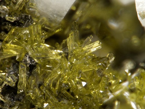


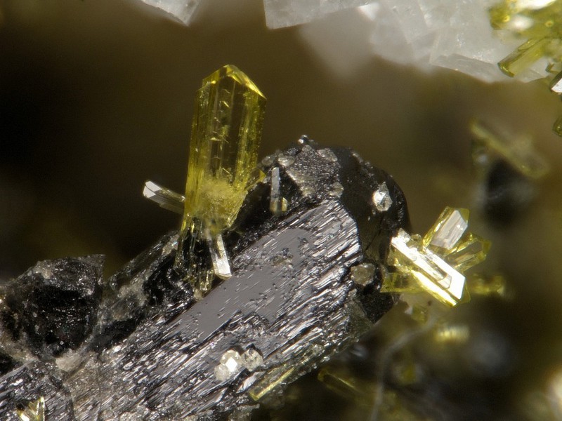


Big Rock Quarry, Granite Mountain area, Little Rock, Pulaski County, Arkansas, USA