 | | Book |
| MINES MINERS MINERALS AND OF WESTERN NORTH CAROLINA Western North Carolina’s Hidden Mineralogical Treasures...E L L 2005 PARKWAY PUBLISHERS, INC. Boone, North Carolina Copyright ©1999 Lowell Presnell All Rights...Mines, miners, and minerals of western North Carolina : western North Carolina’s hidden mineralogical treasures...(hard cover) 1. Mines and mineral resources—North Carolina—History. I. Title. TN24.N8P74 2005 338.4‚7622‚09756—dc22...Domestic Mica Buying Policy 111 20. Western North Carolina & the War Years .119 21. The Mineral Kingdom |
 | | Report (issue) |
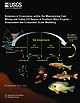
| under a cooperative agreement with the State of North Carolina and the Tennessee Valley Authority Physical...under a cooperative agreement with the State of North Carolina and the Tennessee Falley Authority UNITED...___._ — —— __-__-_-____ Inclusions of muscovite, quartz, and apatite in muscovite..-._-_.____-__-_-_--...Production of sheet and punch mica, 1912-14, in North Carolina, the Southeastern States, and the entire United...data for mica specimens, arranged by lot and by mine or prospect-_-___--_-___-_-.___---___-_____--_ Results |
 | | Report (issue) |
| areas in North Carolina - 11 6. Location of roadless and wilderness areas in South Carolina - 12 7. Location...niobium; Ni, nickel, P, phosphate; Pb, lead; Qtz, quartz; Si, silicon; Sn, tin; Ti, titanium; U, uranium;...Swamp Wilderness Study Area, Charleston County, South Carolina: U.S. Geological Survey Open-File Report...Swamp, and Wambaw Creek Wildernesses, Berkeley and Charleston Counties, South Carolina: U.S. Geological...Sopchoppy River Wilderness Study Area, Wakulla County, Florida: U.S. Geological Survey Bulletin 1431 |
 | | Journal (article/letter/editorial) |
| from the Wood Mine, Cocke County, Tennessee HENRY BARWOOD Indiana Geological Survey 611 North Walnut Grove...examined by the author at rock swaps in western North Carolina. Some of these specimens contained small pink...collectors revealed the source to be the Wood mine in Cocke County, Tennessee. Rather cursory examination of...strengite (Lehnert 1971). The author first visited the mine in 1971 after the initial rush of collectors had...the “strengite” were recovered. At that time the mine area was being allowed to regrow after clear-cutting |
 | | Report (issue) |
| .... . _. . . . . . . . . . . . . . Little Crabtree Creek ............. ............. ............ __... _.............. ............ _.. _. __ . __ . North Toe River._._ .............. .......... _............ ... ......... llO . Above mouth of Buffalo Creek ........ ___ . _........... ........ _. _. _" ....gullying of shoestring type in stubble, Buncombe County, N.C.; B, Rapid erosion in deeply decompose d soil...Southern Power Company, on Catawba .River, Chester County, S.C.; B, Portman plant of Anderson (S. C.) Water |
 | | Report (volume) |
| U.S. Geological Survey published Bulletin 191, North American Geologic Formation Names, by F.B. Weeks...chronologically, is as follows: Weeks, F.B., 1902, North American geologic formation names: Bibliography... W.J., and Kopf, R.W., 1957, Geologic names of North America introduced in 1936-1955: U.S. Geological...Hansen, B.E., 1959, Index to the geologic names of North America: U.S. Geological Survey Bulletin 1056-B...Commission on Stratigraphic Nomenclature, now called the North American Commission on Stratigraphic Nomenclature |
 | | Report (volume) |
| Production ________________ .__________________ Johnson County ___ ___ _ Shady Valley district _________________________...M. E. King prospect_ Maxwell mine___ _ _ Wright mine _______________-_________ Osborn and Hopper prospects_... CONTENTS. Mines and prospects Continued. Johnson County Continued. Mountain City district ____ __________________...Goss mine ________ ___ _____________ Moody prospect_________________________'. _ Carter County '. _ __...__________ Elk mine __,.___________^_____ ______________ Dubault prospect Younce prospectCobb Creek prospect |
 | | Report (issue) |
| CI NORTH CAROLINA DEPARTMENT OF CONSERVATION AND DEVELOPMENT GEORGE R. ROSS, DIRECTOR DIVISION OF MINERAL...Feldspar Deposits of The Bryson City District, forth Carolina BY EUGENE N. CAMERON PREPARED BY GEOLOGICAL SURVEY...WITH THE NORTH CAROLINA DEPARTMENT OF CONSERVATION AND DEVELOPMENT RALEIGH 1951 NORTH CAROLINA DEPARTMENT...Feldspar Deposits of the Bryson City District, North Carolina By N. CAMERON EUGENE PREPARED BY GEOLOGICAL...DEPARTMENT OF THE INTERIOR In cooperation with the NORTH CAROLINA DEPARTMENT OF CONSERVATION AND DEVELOPMENT |
 | | Report (issue) |
| OF THE GREAT SMOKY MOUNTAINS, TENNESSEE AND NORTH CAROLINA GEOLOGICAL SURVEY PROFESSIONAL PAPER 349-C...Cades sandstone.___-____-_-_--__-______ 44 Walden Creek group_______.-_______________ 45 General features...46 Local features._____________________ 46 Area north of Tuckaleechee Cove_ 46 Other areas____________________...Ocoee series (later Precambrian) Continued Walden Creek group Continued Shields formation Continued Stratigraphic..._ ______--___Sedimentary environments of Walden Creek area. _ _________________________ Sedimentary environments |
 | | Report (volume) |
| descriptions __ Introduction _____ __ _ _ _ _ _ Powell Creek and Millard______:_____:__________ Geologic section...Continued. Detailed descriptions Continued. Powell Creek and Millard Continued. Biugham coal _________________:_________...Upper Elkhorn coal______________________ Biggs Branch _________,___________________ Millard coal ___...Elkhorn coals ________.__________________ Daniels Creek ____________ :______________ Millard coal _____...Lower Elkhorn coal_______________________ Harless Creek __________________________ Auxier coal ______________________ |
 | | Report (volume) |
| limestone of Malott (1919)-_______--_________Beech Creek limestone of Malott (1919)-__----___-___. Haney...coal bed.______.__-___---___-_--___---__--__-Gun Creek coal bed________________-___-__---__----__-----Fire...operated by the Kentucky Road Oiling Co. along the North Fork of the Licking River._____________ 3. Photomicrographs...Photomicrographs of limestone and sandstone. A, Beech Creek limestone of Malott, 1919; B, Glen Dean limestone;...beds of the Lee formation in high wall of strip mine on the east side of the Open Fork Valley, Haldeman |
 | | Report (issue) |
| 112-square mile area of westcentral Clearfield County. P articular attention is also paid to the rock......................... ... ...... . Clearfield Creek Formation ...... . . ........... . . ....... . ...Formation ........ . . .. ........... ...... . Laurel Run Formation ......................... .. ....... . . . . . . . . . . . . . . . . . Clearfield Creek Formation shales. . . . . . . . . . . . . . . ....Springs Formation shales ........ ................. . Laurel Run Formation shales ......................... |
 | | Report (issue) |
| ______ . _____ . _____ ....... . 80 Stony Fork-Clear Creek district .................. __ ... __ . _.. ____...______________________ . __________ .. _____ . 109 Yellow Creek clistrid .................. _.. _. __ . ____ ........ __ . __ .. __ . _.. _.... __ .... . Cranes Creek coal ........ _. _... _______________ ............ __ . ___ . _.. ___ . _.. __ . __ . __ Yell ow Creek sandstone member. . __ . ____ . ____ . __ .. ___.................... ___ ............... . Cranes Creek coal ........................................ - |
 | | Report (volume) |
| .. Hallwood and Snow Hill quadrangles (Accomac County)................. Hampton, Isle of Wight, Surry...and Pittsylvania counties)...... Bonsacks, Craigs Creek, Eagle Rock, and Natural Bridge quadrangles (Botetourt...quadrangle (Loudoun County)................................. Bramwell quadrangle (Tazewell County)................................ Middlesboro quadrangle (Lee County).................................. Abingdon quadrangle...counties)................ .Peterstown quadrangle (Giles County).................................. Appendix A: |
 | | Report (issue) |
| ·---·---------·------·----·-----·---··-·-·----·Muscogee CountY---------·---·-----·----·-----·---·--·---------...---··----------·-·-----------·--·Chattahoochee CountY-----···---··----------·---·----···-·---··-·--·..._______________________________ _ v Stewart CountY-----------------------------------------------...----------------------·······-····-····-Talbot CountY-------------------------·········-············...--·----·-········--·-········--·-·-·····Marion County............................................... |
 | | Report (volume) |
| Director Bulletin 876 COAL DEPOSITS OF PIKE COUNTY, KENTUCKY BY CHARLES B. HUNT, GUY H. BRIGGS,...and Pond Creek (Lower Elkhorn) beds__-___.__..__-__--_-__--_____-__--_-__--.__._ Pond Creek (Lower Elkhorn)...___________________ Coal beds between the Pond Creek (Lower Elkhorn) bed and Upper Elkhorn coal zone...and altitudes of coal beds in division 1, Pike County, Ky._.__.___.____.______..________ In pocket 2...and altitudes of coal beds in division 2, Pike County, Ky____________________.______________ In pocket |
 | | Report (issue) |
| Dedication of Patuxent Research Refuge at Snowden Hall, Laurel, MD, June 1939 (Photo by Bureau of Biological Survey);...Visitor Center at the Patuxent Research Refuge in Laurel, MD, documents the history of the Patuxent Research.... 45 Patuxent’s Role in the Development of the North American Breeding Bird Survey John R. Sauer.......Vertical coordinate information is referenced to the North American Vertical Datum of 1988 (NAVD 88). Horizontal...Horizontal coordinate information is referenced to the North American Datum of 1983 (NAD 83). Altitude, as used |
 | | Book |
| minerals gleaned from long-abandoned tailing piles and mine dumps. A third important mineral department may...fossil-hunting localities, organized by state, county, township, section, or other landmark, together...fossils can be cut and polished like any of the other quartz-family minerals. Probably the usual colorful varieties...filling in bone cavities, among them amethyst and quartz crystals, chalcedony, opal, aragonite (a form of...might find one or its parts in the gold placers north of Fairbanks—you will be building your collection |
 | | Report (issue) |
| Murray and James W. Skehan, S.J. Woonsocket and North Scituate Basins of Massachusetts and Rhode Island...-2. Geologic map of the Narragansett, Norfolk, North Scituate, and Woonsocket Basins, Massachusetts and...megafossils. Deposits of the Boston, Woonsocket, and North Scituate Basins and the Harvard Conglomerate at...contents of ash, which is dominantly secondary quartz; and yield 13,000 to 14,700 BTU's per ton. The...Hurn1rd University, Cambridge, 1\Iass. 02139, and North Conwny, N.H. 03860. • State Geologist, l\:lnlne |
 | | Report (issue) |
| ------ 4 3. A, Blowing Cave; B, Falling Springs Creek waterfall ------------------ 8 4. Sketch map bearing...bearing on the possibilities of oil and gas in Wise County, Virginia, as inferred from isocarbs .......................... 72 8. Cascades Creek near its junction with Cedar Creek.................... 72 9. A, Mountain...of the area southwest of Big A Mountain, Russell County, Virginia; B, Panorama looking east across Coombs...4. Projected profiles across the basin of Cedar Creek ..................... 64 5. Block diagram of Mountain |
 | | Book |
| ALLANITE, FERGUSONITE, POLYCRASE, AND EUXENITE QUARTZ OPAL JADE - 140 - - 159 165 - DIOPSIDE...CONCENTRATION OF GEM MINERALS UPON A BEACH CORUNDUM MINE, NORTH CAROLINA CRYSTAL AXES CUBE, OCTAHEDRON, DODECAHEDRON...EXACT SIZES OF, FROM 2 TO 30 GRAINS PREMIER DIAMOND MINE, SOUTH AFRICA PRELIMINARY CONCENTRATION OF DIAMOND-BEARING...DIAMOND-BEARING GRAVEL PYRITE, CRYSTAL FORMS OF QUARTZ, CRYSTAL FORMS OF QUARTZ, CRYSTAL FORMS OF, PRODUCED BY DISTORTION... 26 28 - 72 - 46 RUBY-BEARING GRAVEL, NORTH CAROLINA RUTILE 90 - - SEARCHING GRAVEL FOR DIAMONDS |
 | | Report (issue) |
| clam, orb snail, mayfly larvae, stonefly larvae, creek chub, stoneroller, and bluegill sunfish. Cover and......................5 Map of West Virginia with county boundaries showing locations of USGS 2010–2011...concentrations in fish for (A) Beech Creek and White Oak Creek, (B) Jacks Branch mine drainage, and (C) Conner Run...Run and Little Scary Creek........20 Schematic map of USGS sampling sites and compiled Se data for the...sampling sites and compiled Se data for the Twentymile Creek Basin Ecosystem during 2010-2011............... |
 | | Book (edition) |
| Bedrock Glacial Features 133 North Cascades National Park Development of the North Cascades 173 Box 14.1 What...Volcanoes Hazardous? 174 Regional Structure of the North Denali National Park and Preserve (formerly Mount...South Dakota Theodore Rooseveit National Park, North ND AW OANDA Dakota Grand Canyon National Park...Havasupai, who live in a valley watered by Havasu Creek in the western section of the park. (The name Havasupai...Shivwits Plateau, and then crossed over to Diamond Creek. From this point, after an unsuccessful attempt |
 | | Book |
| Supplying the needs of his Russian clients, the London branch and those of his teams of salesmen traveling annually...1898) Birth of Fabergé silversmith St. Petersburg branch an-der-Oder and marries Marie Luise 1831 Elsner...Alexander E.Tillander. Silversmith Sazikov (Moscow branch) appointed “Supplier to the Court” Aucoc founded...Petersburg Paul Legrand designer at Boucheron branch) appointed “Supplier to the Court” between1870...of the silver department at Ovchinnikov opens a branch in Tiffany’s. St. Petersburg. 1879 Birth of |
 | | Book |
| for much valuable information pertaining to this branch of the subject to the Jury Report of the London... . . . . . . . . . . . . . . . . . . . . . . . Quartz . . . . . . . . . . . . . . . . . . . . . . . ... . . . . . . . . . . . .; . . 266 Common quartz—rose quartz . . . . . . . . . . . . . . . . . . . 4-...species form perfect holohedric combinations. Though quartz and apatite appear as such, I NJ yet properly...Tetartohedric combinations are seen most distinctly in pure quartz or rock crystal, the pyramids of the first kind |


