 | | Report (volume) |
| OF EAST TENNESSEE BY G. W. STOSE AND F. C. SCHRADER Prepared in cooperation with the TENNESSEE STATE...ores in Erwin quartzite. ' _ _ __ Oxide ores in Shady dolomite _ Oxide ores in Watauga shale : __ ___...________________ .__________________ Johnson County ___ ___ _ Shady Valley district _________________________ Reynolds...Hogback mine______ Davis mine_______ _ M. E. King prospect_ Maxwell mine___ _ _ Wright mine _______________-_________...Continued. Johnson County Continued. Mountain City district ____ __________________ Taylor Valley mine__ |
 | | Journal (article/letter/editorial) |
| Tennessee Mineral Locality Index 300 T ennessee covers an area of 41,220 square miles in the southeastern...part of the state. Just prior to crossing the Tennessee River and continuing through the middle of the...Paleozoic sediments and rare igneous rocks of the Valley and Ridge, which change crossing the Great Smoky...Knoxville, Tennessee 37921 taparis@msn.com Figure 1 (top left). Calcite, 5.5 cm high, Elmwood mine, Smith...Smith County. Terry Huizing specimen, Jeff Scovil photo. Figure 2 (above). Fluorite, 13.1 cm wide, Elmwood |
 | | Journal (article/letter/editorial) |
| hydrohetaerolite, chalcophanite, crednerite,woodruffite,and wad. Another group of oxides appearsto have been formed...general, the depth from the surfaceto water in a district increases with the declinein rainfallandvariesfromplaceto...is found 50 to 100 feet belowthe surfacebut in mining operationsthe manganeseoxidesare foundas muchas...esville, Arkansas;Bradleyand Munroe Counties,Tennessee). D. F. HEWETT AND MICHAEL FLEISCHER 2....Socorro district and Little Florida district,New Mexico, and the Aguila district, Mohave County,Arizona |
 | | Report (volume) |
| Deposits of the James River-Roanoke River Manganese District Virginia GEOLOGICAL SURVEY BULLETIN 1008 Geology...·Deposits oftheJatnes River-Roanoke River Manganese District Virginia By GILBERT H. ESPENSHADE GEOLOGICAL...particularly manganese, of the James River-Roanoke River district UNITED STAT.ES GOVERNMENT, PRINTING. OFFICE•...--------Psilomelane type ________________________________ -Wad _________________________ ·-___________________ ...production________________________________________ Prospecting, mining, and milling methods_________________________ Descriptions |
 | | Report (volume) |
| ............................ 71 Northeastern Tennessee........................................... 72......................................... ' 72 Shady Valley............................................................................... Cartersville district.................................................................................. Cave Spring district........................................................................................ 95 Tennessee.............................................. |
 | | Report (issue) |
| HOUSE OF THE GEORGIA COMPANY NEAR \YHlTE , BARTOW COUNTY. GEOLOGICAL SURVEY OF GEORGIA S. W. McCALLIE...Psilomelane ..................................... . Wad ............................................ . Manganite..................................... . MANGANESE MINING INDUSTRY ...•..••.......•...•..••••.••••.••.•••...quartzite ......................... : ...... . Shady limestone .................................. . Cartersville................................... . Appalachian Valley ........................... . Character of surface |
 | | Report (issue) |
| Lower Cambrian rocks of the Rome Formation, the Shady Dolomite, and the Chilhowee Group are exposed. The... The Tablerock thrust sheet is composed of the Shady Dolomite and rocks of the Chilhowee Group. The rocks...miles west into Tennessee. The principal producing mine in this belt was the Cranberry mine at Cranberry...was written by Kerr (1875) before any extensive mining had been done. Bayley (1923) gave a rather complete...complete review of the literature on Cranberry mine. During the present survey the underground workings |
 | | Report (issue) |
| ON CERTAIN UNDEVELOPED TRACTS IN THE SHENANDOAH VALLEY, VIRGINIA. By D. F. HEWETT, G. W. STOSE, F. J....other extensive deposits like that at the Crimora mine might be discovered. The manganese deposits lie...lie along the east side of the Shenandoah Valley, at the foot of the Blue Ridge. For the present investigation...order of prospective promise. wide, and the Crimora mine occupies a central position in it. A preliminary...the rocks in the MANGANESE ORE IN SHENANDOAH VALLEY, VA. 273 lowlands and the necessity of resketching |
 | | Report (volume) |
| it helpful to refer to Survey Bulletin 507, "The mining districts of the western United States," and to...abundant, it may have been completely exhausted by mining or quarrying. Deposits of minerals of wide distribution...because they occur in sufficient quantity to warrant mining for their usual products but because they furnish... 6 USEFUL MINERALS OF THE UNITED STATES. Tennessee........Mr. George H. Ashley, Washington, D. C...See Bauxite and Hallpysite. Asbestos. Tallapoosa County, with corundum deposits near Dudleyville; not found |
 | | Report (issue) |
| CLINTON IRON ORE IN THE CHATTANOOGA REGION OF TENNESSEE, GEORGIA, AND ALABAMA; By ERNEST F. BURCHARD....one sense it comprises the so-called Rockwood district and may be considered to extend as far southward...ore is invariably left for roofs or pillars in mining operations, and much is necessarily impossible...ROCKWOOD DISTRICT. i LOCATION AND EXTENT. The Rockwood district lies in the Tennessee River valley between...principally in Roane County. Ore has been mined in many places along the west side of the valley between Spring |
 | | Report (volume) |
| ....................................... 102 District of Columbia ................................................................................ Tennessee.....................^...........................to refer to Geological Survey Bulletin 507, "The mining districts of the western United States," and to...abundant it may have been completely exhausted by mining or quarrying. Deposits of minerals that are widely...because they occur in sufficient quantity to warrant mining for their usual products, but because they furnish |
 | | Report (issue) |
| Manganese ore deposit Mining and preparation of St. Lukes Hospital tract .. Godlove mine .. /d ore 79 79...Geology ..: .. . . 8t 82 83 Manganese ore deposit Mining and preparation of Rhesa A. Orndorff ore bD...Mountain prospect Scott prospect .. . . . Powells Fort mine Location and geography ...r... ..... History and...counties Achenbach Bath . r00 t00 tract .. I00 County Stephenson prospect 101 101 Gillett prospeet... l0r Little Piney Mountain prospect Alleghany County X'alling Spring iron prospect r03 104 104 104 |
 | | Report (issue) |
| . . . . . . . . . . . . . . . . . 1 Chapter I. Mining Districts of Counties and the State of Utah. .... . . . . . . . . . . . . . . . . . . . . . . 1 County Listings. . . . . . . . . . . . . . . . . . . ... . . . . . . . . . . . . . . . . 1 Chapter II. Mining Districts of Utah . . . . . . . . . . . . . . .... . . . . . . . 4 Mineral Localities Listed by County . . . . . . . . . . . . . . . . . . . . . . . .... . . . . . . . . . . . . . . . . . . 7 Beaver County . . . . . . . . . . . . . . . . . . . . . . . |
 | | Report (issue) |
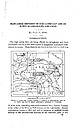
| S. Geological Survey personnel of the various district offices. Each precipitation sample represents...Lower Cambrian rocks of the Rome Formation, the Shady Dolomite, and the Chilhowee Group are exposed. The... The Tablerock thrust sheet is composed of the Shady Dolomite and rocks of the Chilhowee Group. The rocks...BLOWING ROCK QUADRANGLE 81°30' Park f* CRANBER&Y MINE - ...miles west into Tennessee. The principal producing mine in this belt was the Cranberry mine at Cranberry |
 | | Report (volume) |
| 50. II. Tertiary History of the G-rand Caiion District, with atlas, by Clarence E. Dutton, Capt. U. S... Geology of the Comstocls Lode and the Washoe District, with atlas, by George F. Becker. 1882. 4°. xv...of 21 sheets folio. Price $11.00. IV. Conistock Mining and Miners, by Eliot Lord. 1883. 4°. xiv, 451 pp...Price $1.20. VIII. Paleontology of the Eureka District, by Charles Doolittle Walcott. 1884. 4°. xiii...46 pi. and maps. Price $1.75. XII. Geology and Mining Industry of Leadville, Colorado, with atlas, by |
 | | Report (issue) |
| ..:.:..... Appalaehian -ntguntains Appalachian Valley province .... Gnoenepsv Gnor,oev . 6 L2 .....Hamnton shale . 14 ID 22 25 Edwinquartzite.... Shady dblomite Watauea shale . . Upperiimestones of the...Psilomelane lq 42 tq /2 Manga,rrite Pyrolusite Wad . Limonite Other minerals.... Relations of the...Creek or Seibel mine .. iocation geology ore Millins Vicinityof X'rontRoyal County BentonvilletoVauEhanStation...BentonvilletoVauEhanStation Dry Run or Compton mine. . . Bailey prospect .. . . Minei Run bank . Page Prospects near |
 | | Journal (article/letter/editorial) |
| examinedin the laboratory,shouldbe referredto as "wad." Such 272 MICHAEL FLEIgCHER ,4ND WALLACE ...psilomelane.Specimensfrom Tombstone,Arizona, and Lake Valley, New Mexico, showfilament-likefibersof cryptomelane...brown, compact masseswhich would probablybe termed"wad" in the field, also as brownish-black friable masses...1.20 1.18 I 3 6 2 3 3 2 4 Cryptomelane,Mowry Mine, Patagonia dist., Arizona. D 6.863 4.892 3.445...346 3.096 2.651 2.537 2.396 Ramsdellite, Lake Valley, New Mexico. D I D I D 4.08 3.20 10 1 1 |
 | | Report (issue) |
| Division of Conservation DEPARTMENT OF MINES, MINING AND GEOLOGY Garland Peyton, Director THE GEOLOGICAL...Geologist, TVA Published in Cooperation with the Tennessee Valley Authority ATLANTA 1948 Georgia State Division...Division of Conservation DEPARTMENT OF MINES, MINING AND GEOLOGY Garland Peyton, Director THE GEOLOGICAL...the Tennessee Valley Authority ATLANTA 1948 LETTER OF TRANSMITTAL Department of Mines, Mining and...resources in one of Georgia's most active commercial mining areas. The report contains a manuscript on the |
 | | Report (issue) |
| Northeasternmost Tennessee GEOLOGICAL SURVEY Prepared in cooperation with the Tennessee Division of Geology...PROFESSIONAL PAPER 311 Geology of Northeasternmost Tennessee By PHILIP B. KING and HERMAN W. FERGUSON With...PROFESSIONAL PAPER 311 Prepared in cooperation with the Tennessee Division of Geology UNITED STATES GOVERNMENT...Philip Burke, 1903Geology of northeastermost Tennessee, by Philip B. King and Herman W. Ferguson; with...with the Tennessee Division of Geology. Bibliography : p. 4-9, 126-129. 1. Geology Tennessee. 2. Petrology |
 | | Report (issue) |
| occurrences of lead and zinc in twelve counties in the Valley and Piedmont provinces of Virginia. Lead was first...and mining in the district and notable advances have been mad.e in the interpretation of valley stratigraphy..._______ Erwin quartzite ' 13 _________ t4 t6 Shady dolomite (Lower Cambrian) General features 16 ..._____:- 22 27 30 J) Ivanhoe limestone member Shady dolomite south of Austinville_______:_____________:________...-------- County Selected references Louisa and Spotsylvania counties-----Selected references Valley and Ridge |
 | | Report (issue) |
| west-southwestward from Pulaski County, at the center of the State, to Polk County, on the west border. Eecent...Contains an article on the manganese deposits of Polk County, together with analyses and a general description...the manganese ores, methods of prospecting, and mining conditions. No detailed report as a result of...described and to the officials of the different mining companies for their uniformly courteous treatment...M. Nicholson, of Caddo Gap; Will Whisenhunt, of Shady; R. Lowery, W. E. Rainwater, and S. W. Sherrod, |
 | | Journal (article/letter/editorial) |
| location a~ included at the end of each entry. Adair County Chariton River (40-04-05N 92-4 I -23W). septarian...septarian concretions about 2 miles north of the Macon county line. CALCITE crystals enclosing bundles of acicular...hematite, quartz (Broadhead 1873b, 1877). Audrain County Mexico, in fire clay pits and spoil piles: PYRITE...University Library] at 19:58 29 October 2014 Barton County McKarrow’s coal bank (37-37N 94-28W), 2.5 miles...PICKERINGITE, pyrite, siderite (Broadhead 1873b). Bates County Panther Creek, northwest of Rockville in coal deposits: |
 | | Book (edition) |
| YEAR 1687"—DAVID T. DAY, CHIEF OF THE DIVISION OF MINING STATISTICS AND TECHNOLOGY WASHINGTON GOVERNMENT...and consump tion, or better and cheaper means of mining, extraction, and convey ance to market, may in...correspondence has been carried on with geologists, mining engineers, and other local authorities, and various...mmed at Broken Arrow aud Trout creek, in Sc. Clair county. The strata in this field are more faulted und...prong of Canoe creek, in St. Clair county, to Ha\sop creek, in Bibb county, a distance of 60 miles. Down to |
 | | Report (issue) |
| and Butler, G. M.-Arizona lode gold mines and mining: Univ. Ariz., Ariz. Bur. Mines Bull. 137, 1934...Ariz., Ariz. Bur. Mines Bull. 148, 1941. Apache County 2: 17 Gregory, H. E.-Geology Prof. Paper 93, 1917...the Navajo country. U.S. Geol. Survey Cochise County 3:04 Ransome, F. L.-The geology and ore deposits...Tombstone district, Arizona: Univ. Ariz., Ariz. Bur. Mines Bull. 143, 1938. Gila County 4:03 Ransome...Ransome, F. L.-Geology of the Globe copper district, Arizona: U.S. Geol. Survey Prof. Paper 12, 1903. 4:19 |
 | | Report (issue) |
| C. A. Michael. COLD NUGGET FROM SPOTSYLVANIA COUNTY: Longest dimension approximately 13 cm., photograph...updated “check list” just alluded to, (2) a county-by-county listing of the minerals, and (3) resumes of...(Leucoxene) 4 Checklist Pyrolusite (Varvicitc) Wad (Lampaditc) (Lirhiophorirc) Rancicitc Cassitcrite...(Haydcnitc) 9 Virginia Mineral Localities by County This list is included for possible aid in planning...listed only* if localities arc given for them. The county lists do not include com mon rock-making materials |


