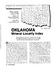
 | | Journal (article/letter/editorial) | | Houston, Texas 77036 ROBERT 0. FAY Oklahoma Geological Survey Norman, Oklahoma 73019 Downloaded by [The Aga...713 15th Street NW Ardmore, Oklahoma 73401 OKLAHOMA Figure 1. Oklahoma counties. Mineral Locality...known for its gypsum crystals and barite roses, Oklahoma also boasts a variety of other species, including...unaware of the variety of minerals available from Oklahoma and think primarily of the prolific gypsum crystals...hundred years, extends into the northeast corner of Oklahoma and has produced notable specimens. Unfortunately |  | | Journal (article/letter/editorial) | | is found in the Harquahala Range in N / E Yuma County of S/W Arizona. Also enclosed are some desert roses...roses (beds of these are found all over Yuma County). I pick up only the well shaped specimens such as...come from the Calico fossil beds of San Bernardino County, Calif." — asks Charley Jones, 14232 Slover Ave...mine dumps in Colorado. At Cripple Creek, Teller County, they found some lustrous, black flakes of hematite..."I am enclosing some pebbles that I believe are dolomite. They were found in a clay bed exposed when ROCKS |  | | Journal (article/letter/editorial) | | nor even under an argon lamp. "Fluorite. Teller County, Colorado." —on label. CONNECTICUT—"Perhaps you...found in Dodge County near Empire, Plainfield and Jay Bird Springs, and in Irwin County near Osierfield...calcite which fl. yellow, s. w. No. 2 is brown xled dolomite on white xline calcite on dark gray limestone...limonite, and light brown limonite on xled white dolomite were the specimens received from Mr. Bignail....from the Colorado shale formation in Judith Basin County, right in the heart of Montana. This site where |  | | Report (volume) | | Prof. G. D. Hubbard, Oberlin College, Oberlb Oklahoma........Prof. D. W. Ohern, Norman. Oregon........See Bauxite and Hallpysite. Asbestos. Tallapoosa County, with corundum deposits near Dudleyville; not found...commercial quantity or quality. Asphalt. Colbert County, small quantity has been shipped from near Leighton;...following localities: Bibb County, Pratts Ferry; Calhoun County, near Tampa; Clay County, T. 20, Pv. 7 E.; Jefferson...Jefferson County, at Elyton; Lee County, at Chewacla lime works; St. Clair County, at Gfeensport; Shelby |  | | Report (volume) | | Moosehead Lake,Jo-Mary Mountain Area, Piscataquis County, Maine lJy G. H. ESPENSHADE 1 '1 E 0 L 0 G I...Moosehead Lake-Jo-Mary Mountain area, Piscataquis County, Maine. 2. Map and sections showing aeromagnetic...MOOSEHEAD LAKE-JO-MARY MOUNTAIN AREA, PISCATAQUIS COUNTY, MAINE By G. H. ESPENSHADE ABSTRACT The Moxie...000 to 1 2 GEOLOGY, MOXIE PLUTON, PISCATAQUIS COUNTY, MAINE KATAHDIN PLUTON MOOSEHEAD LAKEJO-MARY MOUNTAIN...the area. The nearest settlement is the town of Greenville, a few miles south of the mapped area on the |  | | Journal (article/letter/editorial) | | of the many quartz slabs we found. From Tellar County, Colorado." — on label. 30 PLEASE SEND THEM I...radiated goethite on grayish-white cleavage of dolomite. 3. Drusy, white calcite in cavities of dark 31...interior —a type of calcite known as satin spar. OKLAHOMA — A interesting specimen was received from Mrs...Opal Butte, in extreme southern part of Morrow County of northern Oregon, is especially noted for hyalite...Priory." —from Cecil A. Foster, 977 Greenville Ave., Greenville, R. I. TENNESSEE — "The enclosed quartz |  | | Report (issue) | | Donald Bruce 1. A geologic map of a part of Marion County, Missouri: unpublished Masters thesis, Univ....KansasMissouri-Oklahoma-Arkansas: American Assoc. Petroleum Geologists, Tulsa, Oklahoma, 1 sheet, 1966...Branson, Carl C. 1. Patterns of Oklahoma prairie mounds: Oklahoma Geology Notes, vol. 26, no. 11,...1966. 2. Maurice Goldsmith Mehl, 1888-1966: Oklahoma Geology Notes, vol. 26, no. 5, pp. 139-140, portrait...Sole marks in Atoka rocks of platform facies: Oklahoma Geology Notes, vol. 26, no. 9, pp. 236-239, 3 |  | | Report (issue) | | 7#Expanded Explanation Greenville Quadrangle Blue Ridge Rocks Stratified Units Gnt Nantahala Slate,...1978, Preliminary ^eoloric rrmppinr in eastern Greenville Quadrangle 1 unpublished data t scale l:2liOOC...l:2liOOC Or-»nt, V.H., 1958* The geology of Hart County, Georgia: Ga. Gaol. Survey Bull. 67, 7£p.: scale 1:1*6000...Progress report on a peolopic st- dy in Anderson County, South Ca-rolina : S.S. State Development Div....Prrliminary geologic mapping in southeastern Greenville quadrangle: unpublished data: sc*.le 1:2UOOO |  | | Report (issue) | | OF TOPOGRAPHIC AND GEOLOGIC SURVEY George E. W. Love, Director [BLANK PAGE] Mineral Resource Report...Administrative support was provided by George E. W. Love, present State Geologist, Donald M. Hoskins, former...Topographic and Geologic Survey was able to respond to county health officials with details down to the level...zones at a house in Colebrookdale Township, Berks County, which came to the authorities’ attention as having... . . . . . . . . . . . . Quarry L, Northampton County . . . . . . . . . . . . . . . . . . . . . . . |  | | Journal (article/letter/editorial) | | excludes commercial deposits (such as bauxite, dolomite, kaolinite, limestone, and limonite) and reports...Occurrence in Carroll County, Georgia" (November/December 1988). Banks County 184 ROCKS & MINERALS...Bentley provided many of the photographs. Baldwin County Milledgeville district—between the State Sanitarium...pit—east of S.R. 243 near the Baldwin-Wilkerson County line: kaolinite (Martin and Stafford, 1972). Cheatham...property—Route 3, Commerce, 4.8 km from the Jackson County line, 8 km east of Commerce on S.R. 59, and 0.8 |  | | Journal (volume) | | classes: 1. Mines and mineral resources of a given county or area (describing kind, character, distribution...and developments). Conejo Oil Field, Ventura County. Shallow wells (100 pumped by jacks and cables...resources of Plumas County. This will be accompanied by a new geologic map of the county. There is Averill...geology of the Engels and Superior mines, Plumas County, California with a note on the ore deposits of...of the Tejon Eocene at the type locality in Kern County, California Occ. Papers, Cal. Acad. (Sketch map |  | | Report (issue) | | aerial radioactivity, and indoor radon data by county. Because of constraints on the scales of maps presented...topography formed in carbonate rock (limestone or dolomite) environments, solution cavities and fissures...The reports are available in county formats and State summaries. The county reports typically contain both...constraints, it was impractical to examine county soil reports for each county in the United States, so more generalized...(geologic provinces) rather than political ones (state/county boundaries) in which the geology may vary across |  | | Report (chapter) | | 35662, USA 2 Department o f Geology, University o f Florida, Gainesville, Florida 32611, USA Abstract:...lyellcollection.org/ at Université Laval on July 11, 2015 SE USA AND TOGO PHOSPORITES 141 Fig. 2. Major structural...Hawthorn Formation -- Miocene; lower carbonate unit, dolomite with interbeds of Downloaded from http://sp...lyellcollection.org/ at Université Laval on July 11, 2015 SE USA AND TOGO PHOSPORITES clay and phosphorite ( 1 5 -...lyellcollection.org/ at Université Laval on July 11, 2015 SE USA AND TOGO PHOSPORITES 145 Fig. 6. Evolution of theories |  | Robinson, Gilpin R., Lesure, Frank G., Marlowe, J. I., Foley, Nora K., Clark, S.H. (2004) Bedrock geology and mineral resources of the Knoxville 1° x 2° quadrangle, Tennessee, North Carolina, and South Carolina. Open-File Report 2004-1075. US Geological Survey doi:10.3133/ofr20041075 | Report (issue) | | Stone 29 Lightweight Aggregate 30 Limestone and Dolomite 30 Sand and Gravel 30 Industrial Minerals 31 Mineral...the Knoxville l°x2° quadrangle, with State and county boundaries 2 2. Physiographic provinces of the...Knoxville quadrangle 24 14. Areas of limestone, dolomite, and marble resources in the Knoxville quadrangle...near the Knoxville l°x2° quadrangle by State and county 27 4. Recorded production of gold and silver from...district in the Valley and Ridge. 2. Limestone and dolomite of the Valley and Ridge. 3. Sand and gravel and |  | | Report (volume) | | Stone 29 Lightweight Aggregate 30 Limestone and Dolomite 30 Sand and Gravel 30 Industrial Minerals 31 Mineral...the Knoxville 1oX 2° quadrangle, with State and county boundaries 2 2. Physiographic provinces of the...Knoxville quadrangle 24 14. Areas of limestone, dolomite, and marble resources in the Knoxville quadrangle...near the Knoxville 1oX 2° quadrangle by State and county 27 4. Recorded production of gold and silver from...district in the Valley and Ridge. 2. Limestone and dolomite of the Valley and Ridge. 3. Sand and gravel and |  | | Journal (issue) | | University Greenville, N.C . 27834 The Liberty HiJI community is located in northeastern Kershaw County, South...encompasses south central Lancaster County as well as northeastern Kershaw County {Fig. I). These areas are sparingly...abandoned Kelly Bank iron-manganese mine in Rockbridge County, Virginia. Because of its light color and friable...crystallized turquoise from Lynch Station, Campbell County, Virginia (Mitchell, 1977), and also it is unlike...a similar geological environment in Cumberland County, Pennsylvania (Montgomery , 1969). The purpose |  | | Journal (issue) | | University Greenville, N.C . 27834 The Liberty HiJI community is located in northeastern Kershaw County, South...encompasses south central Lancaster County as well as northeastern Kershaw County {Fig. I). These areas are sparingly...abandoned Kelly Bank iron-manganese mine in Rockbridge County, Virginia. Because of its light color and friable...crystallized turquoise from Lynch Station, Campbell County, Virginia (Mitchell, 1977), and also it is unlike...a similar geological environment in Cumberland County, Pennsylvania (Montgomery , 1969). The purpose |  | | Journal (article/letter/editorial) | | bulletin from the discuss "Calcite, Aragonite and Dolomite" American Federation of Mineralogical and demonstrate...the Chairman of the Tax Ad- between calcite and dolomite. A field trip visory Committee, Mrs. Helen M....figures formed naturally in rocks. The Rockland County Mineral & Gem Society, Inc., Spring Valley, N.Y...held at the West Nyack, N.Y., YMCA in The Fulton County Mineral Club, Gloversville, N . Y., is sitting...Western South Carolina Gem & Mineral Society, Greenville, S. C , went to Pacelot, S. C , to an outcropping |  | | Journal (article/letter/editorial) | | xline dolomite. Powellite is an incrustation on the scheelite which in turn incrusts the dolomite. Powellite...the numerous tungsten mines in the Darwin, Inyo County, California, area."—note from James H. Richardson...beveled edges associated with pale brown xled dolomite on xline pyritic rock. The locality for the specimen...on the south bank of the Etowah River, in Dawson County, Ga. Chatoyant masses of olive-gray tourmaline...found this specimen at Graveyard Point In Owyhee County, Idaho, in 1957."—on label accompanying the agate |  | | Report (volume) | | Geology and Petrology of The Greenville Quadrangle Piscataquis and Somerset Counties, Maine By G. H....and mineral compositions in the Moxie pluton, Greenville quadrangle, Maine.___In pocket FIGURE 1. Index...section of the sedimentary rocks exposed in the Greenville quadrangle__________________ 6 3. Diagram showing...28 6. Section on south slope of hill 1568 in Greenville quadrangle. _ 32 7. Diagram showing variations...Chemical analyses of sandstone and slate from the Greenville quadrangle, compared with average composition |  | | Report (volume) | | ............................................. Oklahoma.................................................Mineral resources of Oklahoma and statistics of production from 1901 to 1914: Oklahoma Geol. Survey Bull...See Bauxite and Halloysite. Asbestos. Tallapoosa County, with corundum deposits near Dudleyville; not found...commercial quantity or quality. Asphalt. Colbert County, small quantity has been shipped from near Leighton;...following localities : Bibb County, Pratts Ferry; Calhoun County, near Tampa; Clay County, T. 20 S., R. 7 E.; |  | | Journal (article/letter/editorial) | | clays, gravel, etcetera, — .002 at 1,200+. 148 Greenville, N. C................— .018 Pleistocene, Tertiary...embayment. Trenton on Beekmantown limestone and dolomite; Cambrian sandstone on “gneiss” ; light pre-Cambrian...folded and nearly vertical lime stone, shale, and dolomite, on 3,000± quartzite and schist. Steeply tilted...quartzite, and phyllites. 8,000± limestone and dolomite, folded on 4,500± shales, quartzites, and phyllites...limestone,” et cetera; anticlinal. Lower Knox dolomite on 2,000 shales and limestones, in syncline thrust |  | | Journal (article/letter/editorial) | | at Mille Lacs Lake (North Minnesota) in Aitkin County, about 2y2 miles west of Opstead at Liberty Beach...pieces have been found around Knife Lake in Kanabec County, Minn. " W e are keeping the nugget for our collection...comes from a gravel pit in the hills of Panola County, Miss., between Sardis and Batesville. This is...the crystals occur. I think the matrix is either dolomite or limestone. Among the specimens I obtained is...of moonstone from a new location in Avery 267 County, N. C. This was found on the farm of Bill Burleson |  | | Report (issue) | | Buchanan to east of Greenville; and a fractured-eroded southeast sector, east of Greenville to Harper. The...intersect 1 the continent. -5_ By contrast, off Greenville in the central sector, the surface of the slope...southeast as Greenville, where the sequence thins to less than 1/2 km. The shelf between Greenville and Harper...others (1951). The sedimentary section west of Greenville appears to be significantly thicker than that...pockets of thicker sections estimated southeast of Greenville are probably associated with the St. Paul's and |  | | Journal (article/letter/editorial) | | MINERALS (PART GOOCHLAND By PHILIP East Derry, COUNTY In N edge of the James R., W of Richmond and bordering...Extensive gold mining formerly on ex treme W and county line around Rte 605 to Rte 606. There are several...deep. Bell Shaft. Garden Wall M. Shaft. FLUVANNA COUNTY 2 / 2 M i 4 4 2 2 ROCKS AND MINERALS ...im portant operation in either county and as it is located on the county line can be ascribed to Goochland...Cowherd Granite O. Columbia. Op. before 1900 on E county line. Appears as a small face on N side of Rte |
|


