 | | Book | | siderite, Force Crag Mine, Braithwaite (MNS 4491) Back cover-'Daisy' gypsum, Birks Head Mine, Long Marton (MNS...Gill Mine, Caldbeck Fells (MNS 4492) (top right) Quartz, variety rock crystal, Carrock Fell Mine, Mosedale...(bottom left) Hematite, variety kidney ore, Nab Gill Mine, Boot (MNS 4490) (bottom right) ISBN O 85272 099...District , the hematite ore bodies of west and south Cumbria and the evaporitesof the Vale of Eden. A detailed...extensive hematite deposits of west and south Cumbria has also long been the subject of speculation. | 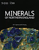 | | Book | | pleasecontact the publishers. Beamish, The North of England Open Air Museum,County Durham [Beamish]: pages........ Teesdale .......................... The Derwent Valley ................ The Tyne Valley ......................... 201 72 Foreword ORTHERN England, an area of great natural beauty, is additionally...District, the north Pennines, Cumbria, various regions of north-east England, and North Yorkshire. Such...ground; trial workings, mine dumps, mine buildings and smeltings, plus mine location maps and a wealth |  | | Book | | Geological Survey 1:50 000 Series Sheet 29 Keswick (England and Wales) Author D G Woodhall Contributors D...uk e-commerce: www.british-geological-survey.co. uk Murchison House, West Mains Road, Edinburgh EH9 3LA...along part of Glenridding valley 48 11 Force Crag Mine, Braitlnvaite 48 12 Sn1all landslip on the north...principal land use. The geology of this part of Cumbria is portrayed on the 1:50 000 Series geological...south of the Causey Pike Fault between Buttennere, Derwent Water and Threlkeld Co1n1non (Fi!,,'1lre l). The |  | | Book | | Geological Survey. 1:50 000 Sheet 29 Keswick (England and Wales). Keyworth, Nottingha1n: British Geological...Geological Survey ll Plates CONTENTS Force Crag Mine, Braithwaite 1 2 View westwards fro1n Place Fell...Woodhall, Regional Editor for Scotland and Northern England, and is based on the approved version of the Sheet...Buttennere, Bassenthwaite Lake (southern part), Derwent vVater, Thirli11ere and Ullswater (southern part)...ubaerial volcanis1n that fonned the Force Crag Mine, Braithwaite [2010 2166]: the treattnent plant with |  | | Report (issue) | | OF OF THE RESEARCH GEOLOGICAL GEOLOGICAL ENGLAND SURVEY AND OF COUNCIL SCIENCES GREAT BRITAIN...BtT2 8ay or through any bookseller Printed in England for Her Majesty’s Stationery Office by Hull Printers...the New Series One-inch Geological Survey Map of England and Wales. This sheet coloured has replaced... : = normal granophyre Limestone om Series above Rough Sketch map illustrating geology of igiietinss...River Caldew above Swineside. Prate III A The beds of Skiddaw Slates are seen above the upper massive |  | | Book | | interested in all aspects of geology in the County of Cumbria and surrounding areas. Members receive regular...Ellenbank Press Park Hill South Camp Road Maryport Cumbria CA15 6JN First published as The Lake District by...Geological and Mineralogical Museum Collections in Cumbria 143 Further Reading Index vi 148 Foreword...broken fragments instead of hammering rock faces. Above all, use this book and enjoy exploring the geology...latitudes with coral reefs. Coal Measures in West Cumbria. Tropical rain forests and extensive deltas. |  | Cooper, A. H., Fortey, N. J., Hughes, R. A., Molyneux, S. G., Moore, R. M., Rushton, A. W. A., Stone, P. (2004) The Skiddaw Group of the English Lake District - Memoir for parts of sheets 22 Maryport, 23 Cockermouth, 24 Penrith, 28 Whitehaven, 29 Keswick, 30 Appleby, 31 Brough and 48 Ulverston. British Geological Survey, Keyworth, Nottingham. | Book | | generally regarded as among the n1ost intractable in England but a recently completed resurvey programme led...similar strata extend beneath 1nuch of northern England. To the west, the Manx Croup of the Isle of ]\...British Geological Survey, 1Vewcastle Printed in the UK for the British Geological Su1vey by . & Co Ltd....Fonnation 60 Teesdale inlier and boreholes in northern England 60 Ingleton Group 61 Four Depositional environment...folds in the Kirk Stile Fonnation, River Caldew above Swineside 85 Disharmonic slump folding ·in the Buttermere |  | | Book | | less importance, such as Old Brandley, Barrow, Thornthwaite, Loweswater, Woodend, Gategill , and Glenderaterra...will rank amongst the best Mines in the North of England . Since 1565 no less than seven smelt mills and... Dale Head , Stoneycroft Gill, Braithwaite, Thornthwaite, Roughtengill, and Greenside ; and the latter...Goldscope Mine 76 81 Dale Head Mine "" Brandley or Brandlehow Mine " 83 86 Yewthwaite Mine "" 39 88 Barrow...Barrow Mine "" 39 90 "3 Stoneycroft Mine 93 Thornthwaite Mine 91 " " Rachel Wood Mine 96 دو Blencathra |  | | Report (issue) | | Publishing Cen tre, Sheffield Printed and bound in England for the British Geological Survey by Linney's Colour...ore fields of west and south Cumbria. The presence of mineralisation and mine spoil is thus a strong influence...and F in stream sediments and waters. Apart from mine spoil, contamination is generally not an important...commonly around the industrial centres of west Cumbria. However, industrial contamination is often restricted...ofYewbarrow, Great Gable and the Sea Fell range, rising above Wastwater lV FORE ORD The English Lake District | | | Report (issue) | | GEOLOGICAL COUNCIL SCIENCES SURVEY OF GREAT BRITAIN ENGLAND AND WALES Geology of the Country around Cockermouthand...the New Series One-inch Geological Survey Map of England and Wales. This sheet has replaced the Old Series...Vertical sections of Carboniferous Limestone Series above Rough Limestone . . .. .. 157 Sketch map illustrating...Seen in River Caldew above Swineside. The beds of Skiddaw Slates are seen above the upper massive andesitic...andesitic lava, and also beneath it immediately above the hammer head, in quaffY at Whitefield Cottage |  | | Book | | ' Frontispiece Landsat imagery of north-west England taken from a height of 900 km. Photograph: National...Geological Society 1978 ISBN 0 9501656 2 X PRINTED IN ENGLAND BY W. S. MANEY AND SON LIMITED LEEDS CONTENTS...Geology 15 Epigenetic Mineralization 16 Offshore Cumbria 17 Hydrogeology C. K. Patrick 18 Environmental...placed the greater part of Scotland in ‘America’, England a :■ dies in ‘Europe’, and regarded the Southern...ccid on or near to the Solway, descending beneath England and Wales. Fitton and Hughes (op. cit.) also noted |  | | Book (edition) | | IExposures behind Hollows Farm, Borrowdale :River Derwent above Derwentwater :Rosthwaite and Borrowdale from...specimen, it may well be neither your fault nor mine, but simply that you have found something unusual...maps. I also extend thanks to the many students of mine who have helped by checking locations and taking...as it is called, is divided up into sections one above the other. To these are given names some of which...time, however, the volcanic cones were built up above sea level for some beds show unmistakable signs |  | | Book | | PO Box 315. Harpenden. Hertfordshire AL5 2ZD. England Telephone: +44 (0)1582 762413 Fax: +44 (0)870 055...Westmorland in the mid- I 970s to form the new county of Cumbria). The confusion appears to have occurred during...on minerals from localities in Cornwall. Devon. Cumbria and Yorkshire. He was renowned for his compendious...Emb'eton quany,nrCockermouth. Cumbria; Gra:nsgill. Ca'.dbeck Fells,Cumbria (kentrolite) HigherPittsmine...Fells,Cumbria; OldGunnls!ake m:ne.Calslock. Cornwall lindgrenite' BrandyGill,Caldbeck Fells,Cumbria WestTurtPitsmine |  | | Book | | scenically it is one of the most complex regions of England and within the space of this volume rigorous selection...side-by-side today, rocks which originated one above the other and many millions of years apart in time...flatness is found, eg the plateau of High Street above Haweswater. The southern section of the massif is...between Shap and Windermere showing extensive areas above 1,000ft. The rest is quiet wooded country sinking...series of Skiddaw Slates below and Silurian strata above, illustrate vividly the contrasting response of |  | | Book (edition) | | Derwentwater (). Tyson) Green ·s Flow Breccia River Derwent above Derwent1,·ater (J. F. A. Stark) The Skiddaw...specimen. it may well be neither your fault nor mine. but simply that you have found something unusual...I also extend my thanks to the m11ny students of mine who have helped by checking locations and taking...as it is called. is divided up into sections one above the other. T o these are given names. some of which...time. howl!vcr. the volcanic cones were built up above sea level for some beds show unmis takable signs |  | Stone, P., Millward, D., Young, B., Merritt, J. W., Clarke, S. M., McCormac, M., Lawrence, D. J. D. (2010) British Regional Geology, Northern England (5th ed.) Geological Survey and Museum | Report (edition) | | GEOLOGICAL SURVEY British Regional Geology Northern England FIFTH EDITION P Stone D lv\illw ard B Young J...DJ D. 2010. British Regional Geology: Northern England (Fifth edition) (Key,vorth, Nottingham: British...189 Lake D istri et l 89 Haematite deposits of Cumbria 196 Isle of Nian 199 N orthern Pennine Orefield...for northern England Index 277 275 ILLUSTRATIONS Figures l Topography of north ern England 2 2 Outline...Outline geology of northern England 3 3 Palaeogeographical reconstructions from the Ordovician to the Palaeogene |  | | Book (volume) | | Press pic, Headington Hill Hall, Oxford O X 3 OBW, England Pergamon Press Inc., 395 Saw Mill River Road, ...explain the ideas of those who have worked on it (and mine, where they differ from those readily available...discussions about six of the major lead-zinc deposits of England with the four Mississippi-Valley type deposits...are located in the following countries: Ireland England Scotland 3 7 1 Wales Norway Sweden 1 7 17 Finland...long periods, a n d , in the latter c a s e , to above 200°C in near-neutral solutions . . . . There may |  | | Report (issue) | | formation, movement and effects. Wallingford, Oxon, UK : Published by the International Association of Hydrological...territorii. Moskva : Izd-vo MGU, 1987. 203.3(694) F767 ENGLAND--GEOLOGY--HASTINGS AREA (EAST SUSSEX). Lake, R...memoir for 1:50,000 geological sheets 320 and 321 (England and Wales). London : H.M.S.O. [for the] Natural...Carleton House Terrace, London, S.W.I. [London, England] : The Royal Society, [1969] 203(072) St878 GEOLOGY...relevant to radioactive waste disposal in the UK. Keyworth, England : British Geological Survey, 1986. (510) |  | | Book | | agents (running water, narrow zone a Just above ground undercut features. As abrasion takes place...hours in a specific period the temperature was above or below the set value and multiplying by the mean...pressure. As air pressure decreases with height above the ground surface, rising air expands, and exerts...smooth if there is a layer of air im- mediately above flow. However, nearly all in it that has...flow, or most commonly a rise in base level. In S England, "o by volume) nitrogen (N^^) 78 08 oxygen (O |  | | Report (issue) | | this sediment. These Cretaceous beach sands occur above present-day sea level. During the Cretaceous, the...Formation at Stop 2. Cretaceous Potomac Formation above (Mixon and others, 1972). The hiatus represents...terrane was separated from the Adirondack-New England region by a major tectonic boundary during Grenvillian...possibly synchronous with the Acadian orogeny in New England. Summary and Regional Implications The new mapping...(98-ft)-wide high-strain zone is exposed in the channel above the diabase dikes. This zone strikes -080° and dips |  | | Book | | ter¬ minology and with compassion for its editors. Above all, use it! since, in the meantime “JOIDES” was...excluded, or the term uppermost Lower Jurassic (above Yeovilian, below Bajocian). may be restricted to...creasing metamorphic grade) biotite - andalusite - cordierite - tional, plutonic, and metamorphic events were...extended period; the last two have been dated radi- cordierite-amphibolite facies. Pressures are rather low:...Freshwater ice consisting of numerous long crys¬ above the equilibrium line. Cf: ablation area; neve. Syn: |  | | Report (issue) | | geophysical, and mineral-resource studies .... . New England ................................ . Advances in...Atlantic coast region ................•.......... New England ............................. . New York ........island arc above Benioff seismic zones, the youngest provinces being l 00 to 200 km above the Benioff...across zinc ore bodies into the Galena Dolomite above and locally form lenses along bedding. These veins...the zinc-lead-copper ore body of Grayville No. 2 mine and several known copper deposits east of Mineral |  | | Report (issue) | | Regional geologic investigations ________________ New England _______________________ Appalachian Highlands and...local officials _____—————————— Integrated surface mine reclamation and land use planning ________———————_...currently considered economic ally feasible to mine; the total amount is only about 250 t of U308. Peat...distribution. Mineralization controls at the Haile gold mine in South Carolina Planetable mapping by R. W. Luce...Henry Bell at the Sericite Pit of the Haile gold mine in Lancas ter County, South Carolina, has revealed |  | | Report (issue) | | geologic investigations _______________ -- _ New England -----------------------------Pleistocene _____...formation of an intensely altered, sericitic capping above the ore. Precipitation of ore was attributed to...300 to 700 ppm W are present in the contact zone above Warfield Hot Springs, the highest amount being in...Sedalia Mine, Colorado Field investigations by D. M. Sheridan and W. H. Raymond at the Sedalia Mine northwest...be localized within and adajcent to a layer of cordierite-garnet-amphibole gneiss. Primary sulfide minerals |  | | Book (edition) | | America. The fossil mammals include — as stated above — remains of very many fossil ape-like creatures...present tribes in the area. As can be seen from the above description, while we know a certain amount about...to occupy positions at Lamu, Brava and Kismayu. England, however, secured their withdrawal in 1876. The...likewise showed population densities which were well above the average, while further north still, in the high...the population to cluster in the area described above is beyond the scope of this paper.’ Indeed, a thorough |
|


