 | | Report (issue) |
| ................... 56 Salt Creek (Blaine County, Oklahoma)................... 58 ^ed !Uver basin......Pease reiver.............. 74 Salt Creek (Cottle County, Texas)...................... 76 I liddle Fork...rocks of Permian and Quaternary ages in western Oklahoma and adjacent parts of Kansas and Texas. 2. Generalized... 3. Map showing the depth to salt in western Oklahoma and adjacent parts of Kansas and Texas. Page ...in Kansas, Oklahoma, and part of northern Texas.......... n 3. Hap of western Oklahoma and adjacent |
 | | Book |
| ROCKHOUND'S GUIDE TO THE GEMS & MINERALS OF OKLAHOMA © E.L.GILMORE 1992 No part of this book may...rockhounds to know where to look for minerals in Oklahoma. who would like This data has been drawn from...from many sources: The publications of the Oklahoma Geological Survey; Scientific publications; the observations...from the author’s own experience in rockhounding Oklahoma for the past 30 years. Some parts of this book...desire of the author to list all minerals found in Oklahoma. The work on this book has covered a period of |
 | | Journal (article/letter/editorial) |
| PERMIAN REDBEDS OF SOUTHWESTERN OKLAHOMA CHARLES N. GOULD Oklahoma City, Oklahoma INTRODUCTION The first papers...papers dealing with the redbeds of Kansas and Oklahoma were published by F. W. Cragin in 18961 and 1897...present writer published a brief description of the Oklahoma redbeds series,3 in which the greater part of...(1897), No. 5, pp. 351 ff. 3 "General Geology of Oklahoma," Second Biennial Report, Department of Geology...History, Territory of Oklahoma (1902), pp. 17-74. 4 "Geology and Water Resources of Oklahoma," V. S. Geol. Survey |
 | | Report (issue) |
| IN OKLAHOMA By A. R. Leonard U. S. Geological Survey Prepared in Cooperation With The Oklahoma Water...Water Resources Board I960 GROUND WATER IN OKLAHOMA By A. R. Leonard One of the first requisites for...investigations was started in cooperation with the Oklahoma Geological Survey, and in 1949 this program was...with the Oklahoma Planning and Resources Board, In 1957 the State Legis ature created the Oklahoma Water...principally in the western half of the State, In Oklahoma current studies are directed toward determining |
 | | Journal (article/letter/editorial) |
| much neglected area is the Glass Mountains of Oklahoma. This area is located between the Cimarron River...the south and extends through Major County and on into Woodward County. The mountains are red — banded with...grey stripes, and topped with a cap rock of white gypsum. The slopes are covered with bits of selenite that...Wild life of all kinds flourish in this part of Oklahoma and at night the lonely cry of the coyote can...view in Glass Mts. area of Northern Major County in N / W Oklahoma. ROCKS AND MINERALS 229 could see huge |
 | | Report (issue) |
| 14k GROUND WATER State of Oklahoma HENRY L. BELLMON, GOVERNOR Oklahoma Water Resources Board Members...Chairman JOHN R. CURRY, Antlers GUY H. JAMES, Oklahoma City GLADE KIRKPATRICK, Tulsa Vice-Chairman ...water-level data for all observation wells in Oklahoma. The first report, published in 1963, contains...related. Oklahoma Water Resources Board GROUND-WATER LEVELS IN OBSERVATION WELLS IN OKLAHOMA, 1961-62...Wood U.S. Geological Survey and M. D. Moeller Oklahoma Water Resources Board The United States Geological |
 | | Report (issue) |
| PHYSIOGRAPHIC PROVINCES AND SECTIONS IN WESTERN OKLAHOMA AND ADJACENT PARTS OF TEXAS. By NE.VIN M. FENNEMAN...between Cimarron and Canadian rivers, in western Oklahoma, which marks the outcrop belt of the Blaine formation...prominent of the several hilly tracts bearing the name Gypsum Hills. The other high escarpments lie mainly in...belong to the same PHYSIOGRAPHIC PROVINCES IN OKLAHOMA AND TEXAS. 117 general class with others in...uncertain reladescribed 'tion" in Oklahoma FIGURE 43. Index map of western Oklahoma and adjacent parts of Texas |
 | | Report (issue) |
| FROM THE PANHANDLE TO CANTON LAKE, NORTHWESTERN OKLAHOMA U.S. GEOLOGICAL SURVEY Open-File Report 81-483...1 - 37° 990 Prepared in cooperation with the OKLAHOMA WATER RESOURCES BOARD UNITED STATES DEPARTMENT...FROM THE PANHANDLE TO CANTON LAKE, NORTHWESTERN OKLAHOMA By Robert E. Davis and Scott C. Christenson Open-File...in cooperation with the OKLAHOMA WATER RESOURCES BOARD Oklahoma City, Oklahoma October 1981 UNITED STATES...Old Post Office Bldg. 215 Dean A. Mc Gee Avenue Oklahoma City, Ok 73102 Telephone : 405-231— 4256 CONTENTS |
 | | Report (issue) |
| GROUND-WATER LEVELS IN OBSERVATION WELLS IN OKLAHOMA 1982-83 CLIMATIC YEARS By Robert L. Goemaat, Lionel...in cooperation with the OKLAHOMA WATER RESOURCES BOARD Oklahoma City, Oklahoma 1984 UNITED STATES DEPARTMENT...McGee Avenue Lakewood, Colorado 80225 Oklahoma City, Oklahoma 73102 Telephone: (405) 231-4256 Telephone:........................................... 30 Oklahoma......................................................................................... 46 Woodward.............................................. |
 | | Report (issue) |
| OE B 3 7bb htfi OKLAHOMA OJSULUOlCAL SURVEY Governor C. N. Haskell, State Superintendent E* D...PRELIMINARY REPORT ON THE MINERAL RESOURCES OF OKLAHOMA BY CHAS. N. GOULD L. L. HUTCHISON AND GAYLORD...Ix ' ^A nHivR5\tY ^IfOW*!*- EXCHANGE OKLAHOMA GEOLOGICAL SURVEY (V Governor C N. Hasfcell...PRELIMINARY REPORT ON THE MINERAL RESOURCES OF OKLAHOMA BY CHAS. N. GOULD L. L. HUTCHISON AND GAYLORD...Asphalt, by Chas. N. Gould . . . Gould . . Gypsum, by Chas. N. Gould 6. Salt, 7. Lead and Zinc |
 | | Report (volume) |
| GEOLOGICAL SURVEY CHARLES D, WALCOTT, DIRECTOR r GYPSUM DEPOSITS IN THE UNITED STATES BY ir- G-EORG-E...technology, and statistics of gypsum, by George I. Adams.......... Properties of gypsum and theory of formation... Character of gypsum.............................................. Varieties of gypsum ................Formation of gypsum.............................................. Deposition of gypsum................. Origin of rock gypsum............................................ Origin of gypsum seams and veins. |
 | | Report (issue) |
| GROUND-WATER LEVELS IN OBSERVATION WELLS IN OKLAHOMA, 1983-84 CLIMATIC YEARS By Robert L. Goemaat, Lionel...in cooperation with the OKLAHOMA WATER RESOURCES BOARD Oklahoma City, Oklahoma 1985 UNITED STATES DEPARTMENT...McGee Avenue Lakewood, Colorado 80225 Oklahoma City, Oklahoma 73102 Telephone: (405) 231-4256 Telephone:........................................... 38 Oklahoma......................................................................................... 52 Woodward.............................................. |
 | | Report (issue) |
| GROUND-WATER LEVELS OBSERVATION WELLS OKLAHOMA 1980-82 IN IN By Robert L. Goemaat, Lionel D. Mize,...in cooperation with the OKLAHOMA WATER RESOURCES BOARD Oklahoma City, Oklahoma 1983 UNITED STATES DEPARTMENT...McGee Avenue Lakewood, Colorado 80225 Oklahoma City, Oklahoma 73102 Telephone: (405) 231-4256 Telephone:............. 47 iv CONTENTS--Continued Paqe Oklahoma........................................................................................... 73 Woodward.............................................. |
 | | Report (issue) |
| Glorieta Sandstone and the Ogallala Formation in the Oklahoma Panhandle and Adioining Areas as Related to Underground...Glorieta Sandstone and the Ogallala Formation in the Oklahoma Panhandle and Adioining Areas as Related to Underground...in the Oklahoma Panhandle and adjoining areas. 2. Geologic sections A-A' and B-B' of the Oklahoma Panhandle...Geologic section C-C' of the Oklahoma Panhandle. 4. Hydrologic map of the Oklahoma Panhandle and adjoining...of wells showing- geologic correlations in the Oklahoma Panhandle ___ 3. Correlation chart showing geologic |
 | | Report (issue) |
| RIVER BASIN NEW MEXICO, COLORADO, KANSAS, AND OKLAHOMA Prepared by the U.S. Geological Survey Water...RIVER BASIN NEW MEXICO, COLORADO, KANSAS, AND OKLAHOMA CONTENTS Page Introduction .....................irrigation wells in Baca County, Colo.. ............ 5. 17 Map of Baca County, Colo., showing net changes...Formation ................ 6. 18 Map of Baca County, Colo., showing net changes in water level, in...RIVER BASIN, NEW MEXICO, COLORADO, KANSAS, AND OKLAHOMA INTRODUCTION This report on ground water in the |
 | | Report (issue) |
| INDEX OF PUBLISHED SURFACE -WATERQUALITY DATA FOR OKLAHOMA 1946-1975 U. S. GEOLOGICAL SURVEY Open- File Report...DATA FOR OKLAHOMA 1946 -1975 compiled by Jerry D. Stoner Open-File Report 77- 204 Oklahoma City, Oklahoma... 5 Figure 2.--Map of Oklahoma showing Counties 6 Figure 3.--Map of Oklahoma showing River Basins ...alphabetical order by county 194 iii Index of Published Surface-Water-Quality Data for Oklahoma, 1946-1975...Stoner INTRODUCTION Surface-water-quality data for Oklahoma have been published by the U.S. Geological Survey |
 | | Report (issue) |
| Survey GROUND-WATER LEVELS IN OBSERVATION WELLS IN OKLAHOMA. 1969-70 By R. L. Moore u.s. Geological Survey...Open-File Report Prepared in cooperation with the Oklahoma Water Resource• Board 1972 CONTENTS Page Intr\:»duction...• • • . • • . . • • • • • • • • • • • . • . S County index. • • • • • • • • • • • • • • • • • . • •... 2. Diagram showing well-numbering system in Oklahoma ••••••••••••••. 4 Index map •having location...water- level measurements of observation wells in Oklahoma have been pub 1iahed. • • . • • • • • • • • • |
 | | Report (issue) |
| OKLAHOMA, A SUMMARY OF ACTIVITIES OF THE U.S. GEOLOGICAL SURVEY, WATER RESOURCES DIVISION, IN FISCAL...GEOLOGICAL SURVEY Open-File Report 91-492 Oklahoma City, Oklahoma 1991 U.S. DEPARTMENT OF THE INTERIOR...Water Resources Division 202 NW 66** St., Bldg. 7 Oklahoma City, OK 73116 Copies of this report can be purchased...the U.S. Geological Survey .............. 3 Oklahoma District organization chart 4 ................Types of investigations and sources of funding for Oklahoma in 1988-90 List of cooperators ...... 5 .. |
 | | Report (issue) |
| K GROUND WATER State of Oklahoma HENRY L. BELLMON, GOVERNOR Oklahoma Water Resources Board Members...CHURCH, Wilburton Vice-Chairman GUY H. JAMES, Oklahoma City GLADE KIRKPATRICK, Tulsa GEORGE E. BENZ...observation wells in Oklahoma. Future reports will be published at 2-year intervals. Oklahoma Water Resources...Board GROUND-WATER LEVELS IN OBSERVATION WELLS IN OKLAHOMA, 1956-60 By D. L. Hart, Jr. U.S. Geological Survey...States Geological Survey in cooperation with The Oklahoma. Water Resources Board 1963 Contents Page Introduction |
 | | Journal (article/letter/editorial) |
| senopyrite in Darien (Fairfield Co.), Levesque, Cross County, Arkansas. The Conn., for over a year. A few weeks...A H O — "This specimen was found in Twin Falls County about 10 miles south of Hagerman, Idaho. These...a fairly new limestone quarry in eastern DeKalb County, 111. There were a few small fossils in the limestone...lined with tiny rock xls. that comes from Brown County, Ind., in the vicinity of Bean Blossom. Its label...label. MISSISSIPPI — "In the creek beds of Panola County, Miss., between Sardis and Batesville, some cutting |
 | | Report (issue) |
| OKLAHOMA A Summary of Activities of the U.S. GEOLOGICAL SURVEY WATER RESOURCES DIVISION in Fiscal Years...GEOLOGICAL SURVEY Open-File Report 88-172 Oklahoma City, Oklahoma 1988 DEPARTMENT OF THE INTERIOR DONALD...Resources Division 215 Dean A. MoGee, Room 621 Oklahoma City, Oklahoma 73102 Copies of this report can be purchased...Conservancy Dist. Oklahoma Conservation Commission USQS Cooperative Matching Funds Oklahoma Dept. of Transportation...Transportation Oklahoma Water Resources Board City of Oklahoma City Grand River Dan Authority Central Oklahoma |
 | | Report (issue) |
| OKLAHOMA GROUND-WATER QUALITY By William F. Horak and Jerry D. Stoner U.S. Geological Survey Open-File...geographic feature and 1985 population distribution in Oklahoma. ...............................................--Principal aquifers and related water-quality data in Oklahoma. .... 7 Figure 3. Selected waste sites and ground-water...ground-water quality information in Oklahoma. ................................................... 8 Figure...aquifers in Oklahoma. IV .............. 9 OKLAHOMA Ground-Water Quality In Oklahoma, ground water |
 | | Report (issue) |
| OKLAHOMA A SUMMARY OF ACTIVITIES OF THE U.S. GEOLOGICAL SURVEY WATER RESOURCES DIVISION FOR 1985 Compiled...by the Oklahoma District Staff U.S. GEOLOGICAL Open-File Report 85-328 Oklahoma City, Oklahoma 1985 ...Office Building 215 Dean A. McQee Avenue Oklahoma City, Oklahoma 73102 Telephone: (405) 231-4256 CONTENTS...mission and program...................... 1 2 Oklahoma District organization chart.......................................... 6 Water conditions in Oklahoma ........................................... 7 |
 | | Report (issue) |
| LOW-FLOW CHARACTERISTICS OF OKLAHOMA STREAMS Prepared in cooperation with the OKLAHOMA WATER RESOURCES BOARD...Geological Survey LOW-FLOW CHARACTERISTICS OF OKLAHOMA STREAMS By Thomas L. Huntzinger Open - File Report...in cooperation with the OKLAHOMA WATER RESOURCES BOARD Oklahoma City, Oklahoma March, 1978 TABLE OF...16 37 38 39 88 ILLUSTRATIONS Figure 1.--Map of Oklahoma showing location of streamflow gaging stations...durations for Clear Boggy Creek near Caney, Oklahoma 4.--Map of Oklahoma showing location of index stations and |
 | | Book |
| Mexico New York North Carolina North Dakota Ohio Oklahoma Oregon Peru1Sylvania Rhode Island South Dakota...Columbus 10, Ohio Oklahoma Geological Survey The University of Oklahoma / 5 3 D Norman, Oklahoma -; 3 u (.,...northeast part of the Coosa Coal Field, St. Clair County, Alabama, by H. E. Rothrock. 1949. 69 B. 50 Well...and G. L. Richardson. 91 1940. district, Franklin County, Alabama, by E . F. Burchard and H. D. Pallister...C".1.5 Geology and mineral resources of Cherokee County, AlaC. 2 Abstract of Alabama clay bama, by E . |

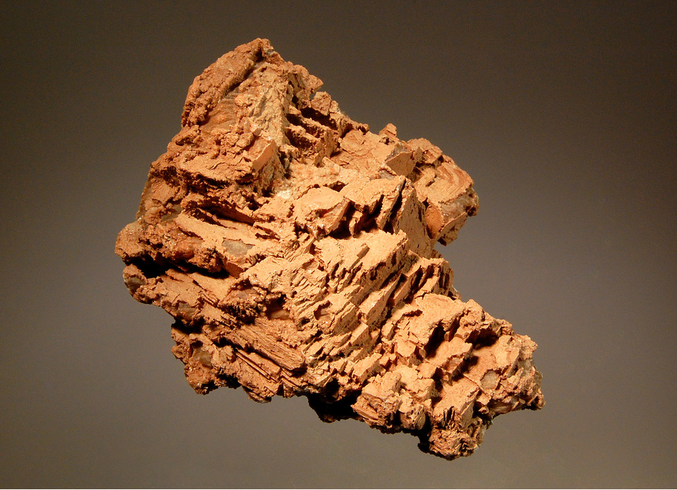


Chimney Rock, Woodward County, Oklahoma, USA