 | | Report (issue) | | Deposits 3 California 3 Kentucky 3 New Mexico 3 Oklahoma 4 Texas 4 Utah 4 Wyoming 4 Canada 5 Trinidad and...California 10 4. Kentucky and New Mexico 11 5. Oklahoma 12 6. Texas and Wyoming 13 7. Utah 14 8. Canada...The reservoir rock and sediment residues from Oklahoma contain more minimum amounts of trace elements...Mining and Technology; Margaret R. Burchfield, Oklahoma Geological Survey; James W. Earley, consultant...identified were quartz, feldspar, calcite, and dolomite (table 1). The semiquantitative mineral determinations | 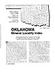 | | Journal (article/letter/editorial) | | Houston, Texas 77036 ROBERT 0. FAY Oklahoma Geological Survey Norman, Oklahoma 73019 Downloaded by [The Aga...713 15th Street NW Ardmore, Oklahoma 73401 OKLAHOMA Figure 1. Oklahoma counties. Mineral Locality...known for its gypsum crystals and barite roses, Oklahoma also boasts a variety of other species, including...unaware of the variety of minerals available from Oklahoma and think primarily of the prolific gypsum crystals...hundred years, extends into the northeast corner of Oklahoma and has produced notable specimens. Unfortunately |  | | Book | | ROCKHOUND'S GUIDE TO THE GEMS & MINERALS OF OKLAHOMA © E.L.GILMORE 1992 No part of this book may...rockhounds to know where to look for minerals in Oklahoma. who would like This data has been drawn from...from many sources: The publications of the Oklahoma Geological Survey; Scientific publications; the observations...from the author’s own experience in rockhounding Oklahoma for the past 30 years. Some parts of this book...desire of the author to list all minerals found in Oklahoma. The work on this book has covered a period of |  | | Report (issue) | | 36. Ceratopea opercula from Texas, Colorado, Oklahoma, Missouri, and Tennessee. 37. Ceratopea opercula...opercula and shells from Arkansas, Texas, Oklahoma, and Pennsylvania. 38. Ceratopea shell and opercula, and...many of the ideas expressed. William Ham of the Oklahoma Geological Survey has given invaluable assistance... In both Tennessee and Oklahoma where beds are limestone rather than dolomite, specimens are more abundant...lithologic character, the northern area being mostly dolomite, and the southern area being mostly limestone |  | | Report (issue) | | you order to SEPM Post Office Box 4756 Tulsa, Oklahoma 74159-0756 U.S.A. ©Copyright 1993 by SEPM (Society...Ellenburger, Arbuckle and Knox carbonates in Texas, Oklahoma, and Alabama; Siluro-Devonian reservoirs of West...Indiana Geological Survey, Ohio Geological Survey, Oklahoma State University, Marathon Oil Company, Masera...SOME OF THE ARBUCICLE CORES IN OKLAHOMA Z. Al-Shaieb and M. Lynch (Oklahoma State University and UNOCAL)...(Texas Bureau of Economic Geology) (Published in Oklahoma Geologic Survey Spec. Pub. 91-3) ..... . 181 |  | | Report (issue) | | GEOLOGIC LOGS PQR SELECTED DEEP WELLS IN PARTS OP OKLAHOMA, TEXAS, AND NEW MEXICO by Scott C. Christenson...GEOLOGICAL SURVEY Open-Pile Report 86-541 Oklahoma City, Oklahoma 1988 DEPARTMENT OF THE INTERIOR DONALD...Resources Division 215 Dean A. MoGee, Room 621 Oklahoma City, OK 73102 U.S. Geological Survey Books and... GEOLOGIC LOGS FOR SELECTED DEEP WELLS IN PARTS OF OKLAHOMA, TEXAS, AND NEW MEXICO By Scott C. Christenson...geologic logs for selected deep wells in parts of Oklahoma, Texas, and New Mexico was prepared by the U.S |  | | Journal (article/letter/editorial) | | year I9oo, the Mid-Continent Field of Kansas and Oklahoma produced74,714 barrels of oil. In the year I9II...attempt to forecastthe future of the industry in Oklahoma. Practically all the oil and gas so far found...rocks. Carboniferous rocks occupy all of eastern Oklahoma,exceptparts,or all, of a half dozencountieseast...age. In theserocksno oil, or gas,hasbeenfound in Oklahoma,except a limited amount in the vicinity of the...sub-Pennsylvanian, Cretaceousor Tertiary depositsin Oklahoma. With thesefacts in mind it may not be difficultto |  | | Journal (article/letter/editorial) | | Mountains, about 8 miles south-east of Mina, Esmeralda County. They came to light in June, 1913, but there were...age; the cinnabar is intergrown with calcite and dolomite. Northwards greywacke, slate, and chert form the...deposits are situated 6 miles east of Beatty, Nye County, in the Fluorine mining district, partly on Bare...The general country rock is a fine-grained grey dolomite, of Silurian age, which is massively bedded and... Hill report on the economic geology of Gilpin County, Colorado. The ores are divisible into five groups: |  | | Report (volume) | | Cambrian dolomite- ____________ Oxide ores in Erwin quartzite. ' _ _ __ Oxide ores in Shady dolomite _ Oxide...Production ________________ .__________________ Johnson County ___ ___ _ Shady Valley district _________________________... CONTENTS. Mines and prospects Continued. Johnson County Continued. Mountain City district ____ __________________...Moody prospect_________________________'. _ Carter County '. _ __ ________ Butler district _________________...____________________________ T. J. Brummett mine Unicoi County Unicoi district ________ Susan Brummett mine._ |  | | Journal (issue) | | 995 00 complete Free shipping in continent USA Made in USA Grit Sizes 60 to 200,000 1.0" hole with...with 3/4", 5/8" & 1/2" bushings Our made in USA soft wheels will last you 3-4 times longer than imported...monthly meetings of clubs, including the South Orange County Gem & Mineral Society. Usually, Walt also uses...Oceanview Mine in the Pala region of San Diego County, California. Field trip participants can dig and...in Wyoming and “Paul Bunyan’s Woodpile” in Utah, USA; the “Baigong Pipes” in China; and the “Cliff of |  | | Report (volume) | | Prof. G. D. Hubbard, Oberlin College, Oberlb Oklahoma........Prof. D. W. Ohern, Norman. Oregon........See Bauxite and Hallpysite. Asbestos. Tallapoosa County, with corundum deposits near Dudleyville; not found...commercial quantity or quality. Asphalt. Colbert County, small quantity has been shipped from near Leighton;...following localities: Bibb County, Pratts Ferry; Calhoun County, near Tampa; Clay County, T. 20, Pv. 7 E.; Jefferson...Jefferson County, at Elyton; Lee County, at Chewacla lime works; St. Clair County, at Gfeensport; Shelby |  | | Report (issue) | | AND FUEL RESOURCES OF THE SOUTHERN PART OF THE OKLAHOMA COAL FIELD PART 2. THE LEHIGH DISTRICT COAL, ATOKA...coal resources of the portion of the southeastern Oklahoma coal field extending northeastward from Coalga...thence eastward through Wilburton and Howe to the Oklahoma-Arkansas State line. The geologists have prepared...bulletin covering this portion of the southeastern Oklahoma coal field. No edition of the consolidated volume...district to six 30-minute quadrangles in southern Oklahoma ______________________ 95 7. Map showing areal |  | | Report (volume) | | Correlation chart of Carboniferous rocks in Arkansas and Oklahoma, by Mackenzie Gordon, Jr _________________________________...in the eastern part of the Nevada Test Site, Nye County, Nev ___________ __ 51 3. Map showing known distribution...in the eastern part of the Nevada Test Site, Nye County, Nev ____ 52 4. Map showing known distribution...Nye County, Nev _________ 53 5. Correlation chart of Carboniferous rocks in Arkansas and Oklahoma ___...(of Caney Late Mississippian (Mera-South-central Oklahoma __ Shale). mecian). Alsea Formation ____ Oligocene___________ |  | | Report (volume) | | ............................................. Oklahoma.................................................Mineral resources of Oklahoma and statistics of production from 1901 to 1914: Oklahoma Geol. Survey Bull...See Bauxite and Halloysite. Asbestos. Tallapoosa County, with corundum deposits near Dudleyville; not found...commercial quantity or quality. Asphalt. Colbert County, small quantity has been shipped from near Leighton;...following localities : Bibb County, Pratts Ferry; Calhoun County, near Tampa; Clay County, T. 20 S., R. 7 E.; |  | | Journal (article/letter/editorial) | | left). Calcite, 5.5 cm high, Elmwood mine, Smith County. Terry Huizing specimen, Jeff Scovil photo. Figure...(above). Fluorite, 13.1 cm wide, Elmwood mine, Smith County. Francis Benjamin specimen, Jeff Scovil photo....Smith County. Terry Huizing specimen and photo. Figure 4 (right). Cumberland mine, Smith County. Travis...earths to make saltpeter, at Nicojack Cave in Marion County, then nitromagnesite at the same location (Shepard...Sevier County (Coskren and Lauf 2000). The following index is arranged alphabetically by county. It is |  | | Report (volume) | | Journal of Science, vols. 21, 22. Columbus, Ohio. Oklahoma Geological Survey: Circular, nos. 10, 11. Norman...Virginia Geological Survey: County Reports, Nicholas County, Tucker County. Morgantown, W. Va. Wisconsin...30, 1921. 12. Geology of Lemieux township, Gaspe County, Quebec: Canada, Geol. Survey, Summ. Rept., 1921...Glacial geology [of the Mount Marcy quadrangle, Essex County, New York]: New York State Mus. Bull. nos. 229...23-24, 1 fig., September, 1920. Anderson, John Carter. 36. Ore deposits of the Pioche district, Nevada: |  | Ryder, Robert T., Repetski, John E., Harris, Anita G., Lentz, Erika E. (2014) Stratigraphic framework of Cambrian and Ordovician rocks in the central Appalachian basin from Campbell County, Kentucky, to Tazewell County, Virginia: Chapter E.2.4 in Coal and petroleum resources in the Appalachian basin: distribution, geologic framework, and geochemical character. Professional Paper 1708e.2.4. US Geological Survey doi:10.3133/pp1708e.2.4 | Report (issue) | | 9060–T Shepherd No. 8807–T Stamper Lewis Co., Ky. Carter Co., Ky. 7 6 5 Inland Gas Company Inland Gas Company...No. 538 Coalton Tract No. 542 Young No. 1 Smith Carter Co., Ky. Lawrence Co., Ky. Wayne Co., W. Va. FEET...Knox Group1 Rose Run Sandstone Copper Ridge Dolomite Conasauga Formation 5 Conasauga5 Formation ...Formation undifferentiated dolomite f1 lle Limesto ne unnamed dolomite member 10,000 9000 The Upper...Upper Cambrian and Lower Ordovician dolomite with minor sandstone and chert that lies between the Knox |  | | Journal (issue) | | sec. 35, T. 5 S., R. 1 Criner Hills, Carter E., County, Okla. ? grandis Cooper, new species i> of...member), Allumette Island, Ottawa River, Pontiac County, Ontario, Canada. D. Lingulella brainerdi (Raymond)...Hickory Creek, about center of sec. 35, T. 5 Carter County, Okla. SMITHSONIAN MISCELLANEOUS COLLECTIONS...gouldi zone), branch of 1 E., Criner Hills, Carter County, Okla. D. Lingulella rugosilinea Cooper, new...south of Ottawa, Gloucester Township, Carleton County, Ontario, Canada. Plate 5 Glossella, Lingulella |  | Buursink, Marc L., Craddock, William H., Blondes, Madalyn S., Freeman, Phillip A., Cahan, Steven M., DeVera, Christina A., Lohr, Celeste D. (2013) Geologic framework for the national assessment of carbon dioxide storage resources: Arkoma Basin, Kansas Basins, and Midcontinent Rift Basin study areas. Open-File Report Vol. 2013 (2012-1024) US Geological Survey doi:10.3133/ofr20121024f | Report (issue) | | Arkoma Basin is situated in central Arkansas and Oklahoma and contains a continuous succession of Paleozoic...Missouri and the Cherokee platform in northeastern Oklahoma. The Kansas Basins study area includes the Salina...Basin, which is situated in central Arkansas and Oklahoma, contains a continuous succession of Paleozoic...Missouri and the Cherokee platform in northeastern Oklahoma (fig. 1). The basin was part of a larger, south-facing...extensive seal limited to the Arkoma Basin in Oklahoma. The Arbuckle Group, Simpson Group, and Viola |  | | Report (volume) | | Woodford shale in Oklahoma. Columnar sections of the Chattanooga shale in Oklahoma, Arkansas, and Missouri...sections of the Arkansas novaculite in Arkansas and Oklahoma. Page FIGTIKE 32. 33. 34. 35. Index map of sample...have been recognized over large parts of Kansas, Oklahoma, Arkansas, and Missouri, and are partial or total...Woodford shale was examined at 10 localities in Oklahoma. Uranium content of the samples ranges from less...examined and sampled at 7 outcrop localities in Oklahoma, 10 in Arkansas, and 1 in Missouri, and samples |  | | Report (volume) | | Bulletin, nos. 23-25. Hartford, Conn. Delaware County Institute of Science: Proceedings, vol. 7, no....Science: Proceedings, vol. 6, pt. 4. Columbus, Ohio. Oklahoma Geological Survey: Bulletin, nos. 19, 20, 23-25...Chicago, 111. West Virginia Geological Survey: County Reports, Logan and Mingo; Boone; Wyoming and McDowell...14. Ancient auriferous gravel channels of Sierra County, California: Am. Inst. Min. Eng., Trans., vol....Preliminary concentration tests on Mesabi ores [Itasca County, Minnesota]: Minnesota Univ., School of Mines, |  | | Journal (article/letter/editorial) | | School of Mines, 1500 Illinois St., Golden, CO 80401, USA Hydrologic Science and Engineering Program, Colorado...School of Mines, 1500 Illinois St., Golden, CO 80401, USA c Department of Physics, Astronomy and Geosciences...Towson University, 8000 York Road, Towson, MD 21252, USA d Urban Environmental Biogeochemistry Laboratory...Towson University, 8000 York Road, Towson, MD 21252, USA e Geology and Geological Engineering Department,...School of Mines, 1500 Illinois St., Golden, CO 80401, USA b a r t i c l e i n f o Article history: Received |  | | Book | | Mexico New York North Carolina North Dakota Ohio Oklahoma Oregon Peru1Sylvania Rhode Island South Dakota...Columbus 10, Ohio Oklahoma Geological Survey The University of Oklahoma / 5 3 D Norman, Oklahoma -; 3 u (.,...northeast part of the Coosa Coal Field, St. Clair County, Alabama, by H. E. Rothrock. 1949. 69 B. 50 Well...and G. L. Richardson. 91 1940. district, Franklin County, Alabama, by E . F. Burchard and H. D. Pallister...C".1.5 Geology and mineral resources of Cherokee County, AlaC. 2 Abstract of Alabama clay bama, by E . |  | | Report (volume) | | and Railroad Company, near Bessemer, Jefferson County, Ala. Limestone is 40 to 50 feet thick and averages...1953, Progress report of limestone survey, Knox County [Maine], in Report of the State Geologist for 1951-1952:...of deposits in each. Most important uses of Knox County limestones are in agriculture, in the chemical...Of 25 localities studied, 3 in Polk County and 1 in Clackamas County have commercial significance. Listed...Geology and mineral resources of eastern Cassia County, Idaho: Idaho Bur. Mines and Geology Bull. 14, |  | | Report (issue) | | from the Henry house and Haragan formations of Oklahoma. The unpublished index of Ostracoda compiled by... R. 29 W., Fayetteville quadrangle, Washington County, Ark. Collected by F. W. Simonds, date unknown... R. 29 W., Fayetteville quadrangle, Washington County, Ark. Collected by R. D. Mesler, 1906. 7698 green...Salem limestone, quarries at Stineville, Monroe County, Ind. Collected by Elliott Marshall for G. H. Girty...blue. Union Dairy member of Hoxbar formation, Carter County, Okla. (See Sohn, 1954, p. 3 for description |
|


