登录注册
Quick Links : Mindat手册The Rock H. Currier Digital LibraryMindat Newsletter [Free Download]
主页关于 MindatMindat手册Mindat的历史版权Who We Are联系我们于 Mindat.org刊登广告
捐赠给 MindatCorporate Sponsorship赞助板页已赞助的板页在 Mindat刊登 广告的广告商于 Mindat.org刊登广告
Learning CenterWhat is a mineral?The most common minerals on earthInformation for EducatorsMindat ArticlesThe ElementsThe Rock H. Currier Digital LibraryGeologic Time
搜索矿物的性质搜索矿物的化学Advanced Locality Search随意显示任何一 种矿物Random Locality使用minID搜索邻近产地Search Articles搜索词汇表更多搜索选项
搜索:
矿物名称:
地区产地名称:
关键字:
 
Mindat手册添加新照片Rate Photos产区编辑报告Coordinate Completion Report添加词汇表项目
Mining Companies统计会员列表Mineral MuseumsClubs & Organizations矿物展及活动The Mindat目录表设备设置The Mineral Quiz
照片搜索Photo GalleriesSearch by Color今天最新的照片昨天最新的照片用户照片相集过去每日精选照片相集Photography

Duncan Britton's Photo Gallery

Mine dump surround debris-filled shaft

08160530015671251277028.jpg
Seaboard Mine, Virgilina Mining District, Halifax County, Virginia, USA

Around 10' at its tallest, this pile of tailings surrounds the debris-filled remains of an old shaft. Quartz with Azurite and Malachite can be found here.
Photo ID: 996713     Uploaded by: Duncan Britton   Upload date: 2019-08-30   View Count: 93    Status: Public galleries    Type: Photo - 4032×3024 (12.2 Mpix)

View of debris-filled shaft

06843230015671251284596.jpg
Seaboard Mine, Virgilina Mining District, Halifax County, Virginia, USA

This picture shows a large shaft (around 25' in diameter) which was filled with debris to within 10' or so of the surface.
Photo ID: 996711     Uploaded by: Duncan Britton   Upload date: 2019-08-30   View Count: 90    Status: Public galleries    Type: Photo - 4032×3024 (12.2 Mpix)

View down shaft

05382310015671251292738.jpg
Tungsten Queen Mine and plant, Tungsten, Hamme Tungsten Mining District, Vance County, North Carolina, USA

This picture was taken looking down from the collar of a shaft at the mine. A rough estimate of the collar's dimensions would be around 8'+ wide and 16'+ long. The shaft continues to a great depth, with water at the bottom.
Photo ID: 996701     Uploaded by: Duncan Britton   Upload date: 2019-08-30   View Count: 385    Status: Public galleries    Type: Photo - 3024×4032 (12.2 Mpix)

Sketch of the mine workings

08726980015335426966562.jpg
Krebs Barite Mine, Del Rio Mining District, Cocke County, Tennessee, USA

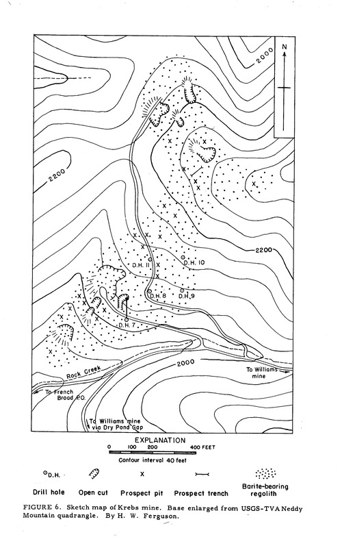
Taken from page 203 of Ferguson and Jewell's "Geology and Barite Deposits of the Del Rio District, Cocke County, Tennessee."
Photo ID: 902629     Uploaded by: Duncan Britton   Upload date: 2018-08-06   View Count: 170    Status: Public galleries    Type: Photo - 2222×3484 (7.7 Mpix)

Map of the Williams Mine workings

09746570015335202828419.jpg
Williams Mine, Del Rio Mining District, Cocke County, Tennessee, USA

Taken from page 195 of Ferguson and Jewell's "Geology and Barite Deposits of the Del Rio District, Cocke County, Tennessee."
Photo ID: 902628     Uploaded by: Duncan Britton   Upload date: 2018-08-06   View Count: 160    Status: Public galleries    Type: Photo - 5560×3318 (18.4 Mpix)

LIDAR Imagery of Williams Mine

00880320015335079139374.jpg
Williams Mine, Del Rio Mining District, Cocke County, Tennessee, USA

This image was created using Tennessee LIDAR data. The "access road" to the adits is the suggested easiest path of approaching the mine. The yellow point represents the coordinates given for the mine on the website.
Photo ID: 902612     Uploaded by: Duncan Britton   Upload date: 2018-08-05   View Count: 162    Status: Public galleries    Type: Photo - 663×418 (0.3 Mpix)

View of upper mine adits

02812640015335079134719.jpg
Williams Mine, Del Rio Mining District, Cocke County, Tennessee, USA

This picture appears on page 196 of Ferguson and Jewell's 1951 work on the Del Rio district. The picture is looking up slope, with the 2nd mine entrance on the right of the picture. The third mine entrance is on the other side of the column behind where the man is standing. Both of the entrances are still open and provide access to the mine's workings.
Photo ID: 902595     Uploaded by: Duncan Britton   Upload date: 2018-08-05   View Count: 249    Status: Public galleries    Type: Photo - 1678×2550 (4.3 Mpix)

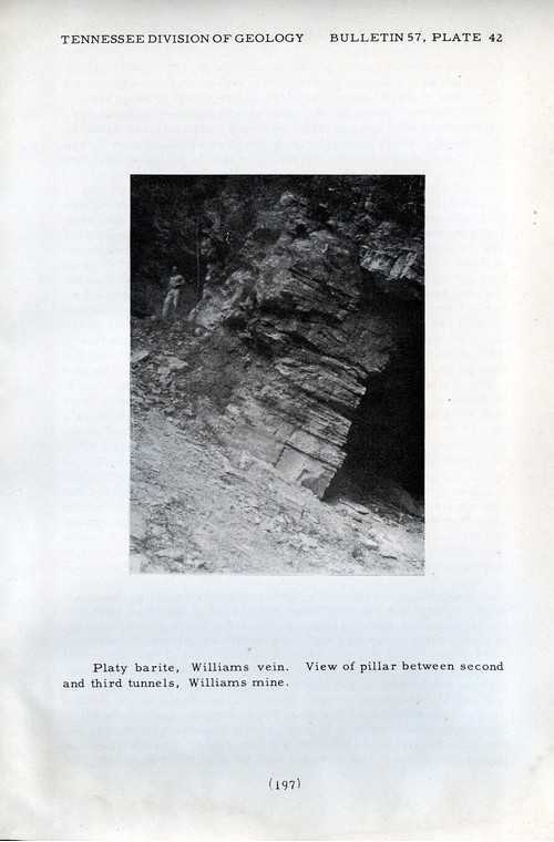
Main entrance of the mine

05646280015335079146694.jpg
Williams Mine, Del Rio Mining District, Cocke County, Tennessee, USA

This picture appears on page 197 of Ferguson and Jewell´'s 1951 treatment of the area. The entrance to the mine shown in the picture has caved, although other adits remain open.
Photo ID: 902589     Uploaded by: Duncan Britton   Upload date: 2018-08-05   View Count: 280    Status: Public galleries    Type: Photo - 1681×2503 (4.2 Mpix)

Wall of the cut

00930530015326395316423.jpg
Johnson's Cove Mine, Yancey County, North Carolina, USA

This image shows one of the walls of the mine's cut, taken near the end of the cut filled with water. The image was captured June 17th, 2018.
Photo ID: 901273     Uploaded by: Duncan Britton   Upload date: 2018-07-26   View Count: 94    Status: Public galleries    Type: Photo - 2448×3264 (8.0 Mpix)

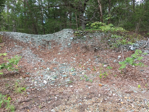
View looking into the mine

04052550015326395335305.jpg
Johnson's Cove Mine, Yancey County, North Carolina, USA

The image shows the central part of the mine. Part of the large cut was flooded and the rest of the cut has been eroded significantly. Nonetheless, high rock walls stand on both sides of parts of the cut. The walls of the cut stand at least 30' high and are covered in places by mosses and ferns.
Photo ID: 901265     Uploaded by: Duncan Britton   Upload date: 2018-07-26   View Count: 94    Status: Public galleries    Type: Photo - 2448×3264 (8.0 Mpix)
Page 1 of 2 (1 to 10 of 13 total)
1 2
 
矿物 and/or 产地  
Mindat Discussions Facebook Logo Instagram Logo Discord Logo
版权所有© mindat.org1993年至2024年,除了规定的地方。 Mindat.org全赖于全球数千个以上成员和支持者们的参与。
隐私政策 - 条款和条款细则 - 联络我们 - Report a bug/vulnerability Current server date and time: 2024.4.25 20:56:38
Go to top of page