登录注册
Quick Links : Mindat手册The Rock H. Currier Digital LibraryMindat Newsletter [Free Download]
主页关于 MindatMindat手册Mindat的历史版权Who We Are联系我们于 Mindat.org刊登广告
捐赠给 MindatCorporate Sponsorship赞助板页已赞助的板页在 Mindat刊登 广告的广告商于 Mindat.org刊登广告
Learning CenterWhat is a mineral?The most common minerals on earthInformation for EducatorsMindat ArticlesThe ElementsThe Rock H. Currier Digital LibraryGeologic Time
搜索矿物的性质搜索矿物的化学Advanced Locality Search随意显示任何一 种矿物Random Locality使用minID搜索邻近产地Search Articles搜索词汇表更多搜索选项
搜索:
矿物名称:
地区产地名称:
关键字:
 
Mindat手册添加新照片Rate Photos产区编辑报告Coordinate Completion Report添加词汇表项目
Mining Companies统计会员列表Mineral MuseumsClubs & Organizations矿物展及活动The Mindat目录表设备设置The Mineral Quiz
照片搜索Photo GalleriesSearch by Color今天最新的照片昨天最新的照片用户照片相集过去每日精选照片相集Photography

Russell Hartill's Photo Gallery

NKY-0GGSphalerite ZnS

Multiple photos available
02230780017056367149690.jpg
Horn Silver Mine, Frisco, San Francisco Mining District, Beaver County, Utah, USA

Dimensions: 2 cm x 3 cm x 1 cm

Sphalerite

Copyright: © Russ Hartill      Photo ID: 1254450     Uploaded by: Russell Hartill   Upload date: 2022-10-31   View Count: 42    Status: Public galleries    Type: Photo - 3024×4032 (12.2 Mpix)

4CM-DFPGold Au

09834010017056367213298.jpg
Alaska, USA

Field of View: 6 cm

Copyright: © Russ Hartill      Photo ID: 1253290     Uploaded by: Russell Hartill   Upload date: 2022-10-26   View Count: 19    Status: Public galleries    Type: Photo - 1696×804 (1.4 Mpix)

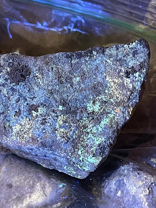
JG1-PCTOlivenite Cu2(AsO4)(OH)

02050350017056367332958.jpg
Gold Chain Mine, Mammoth, Tintic Mining District, Juab County, Utah, USA

Field of View: 1.5 mm

Olivenite with what appears to be auriacusite. Other minerals not in field of view include bariopharmacosiderite. Self collected in March 2021 during field trip organized by Rick Dalrymple.
Photo ID: 1172002     Uploaded by: Russell Hartill   Upload date: 2021-10-10   View Count: 17    Status: Public galleries    Type: Photo - 2040×1530 (3.1 Mpix)

Oak of the Golden Dream

03245970014948275809078.jpg
Gold discovery site, Placerita Canyon, Placerita Canyon State Park, Los Angeles County, California, USA

Francisco Lopez took a nap under this oak tree on March 9, 1842 on the occasion of his 40th birthday. It is said he dreamt of becoming rich. Upon awakening, he pulled up some wild onions, and discovered gold clinging to the onion's roots.
Copyright: © Russ Hartill/The Living West      Photo ID: 736059     Uploaded by: Russell Hartill   Upload date: 2016-03-10   View Count: 87    Status: Public galleries    Type: Photo - 757×1142 (0.9 Mpix)

Close up of mural depicting 1842 Gold Discovery

05465830014948275808038.jpg
Gold discovery site, Placerita Canyon, Placerita Canyon State Park, Los Angeles County, California, USA

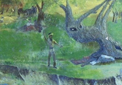
Close up of mural showing Francisco Lopez holding some wild onions in his uplifted hand.
Copyright: © Russ Hartill/The Living West      Photo ID: 736058     Uploaded by: Russell Hartill   Upload date: 2016-03-10   View Count: 79    Status: Public galleries    Type: Photo - 393×275 (0.1 Mpix)

Mural depicting 1842 Gold Discovery

05916650014948275809506.jpg
Gold discovery site, Placerita Canyon, Placerita Canyon State Park, Los Angeles County, California, USA

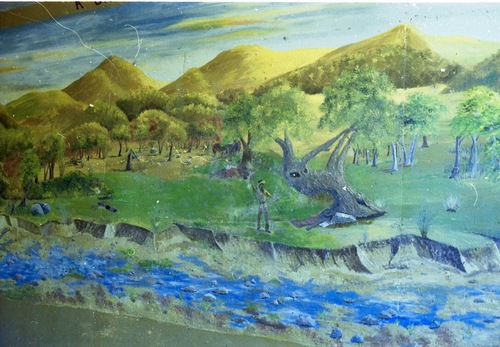
On March 9, 1842, Francisco Lopez pulled some wild onions out of the ground near an oak tree, and discovered gold clinging to the onion's roots.
Copyright: © Russ Hartill/The Living West      Photo ID: 736057     Uploaded by: Russell Hartill   Upload date: 2016-03-10   View Count: 156    Status: Public galleries    Type: Photo - 1089×756 (0.8 Mpix)

Warning Sign

04382790014947860973697.jpg
Gold discovery site, Placerita Canyon, Placerita Canyon State Park, Los Angeles County, California, USA

No gold panning allowed at the site of the first commercial gold mining site in Southern California.
Copyright: © Russ Hartill/The Living West      Photo ID: 736056     Uploaded by: Russell Hartill   Upload date: 2016-03-10   View Count: 212    Status: Public galleries    Type: Photo - 520×862 (0.4 Mpix)

Entrance sign to the County Park

08451540014948275801830.jpg
Gold discovery site, Placerita Canyon, Placerita Canyon State Park, Los Angeles County, California, USA

View of the entrance sign to Placerita Canyon Park
Copyright: © Russ Hartill/The Living West      Photo ID: 736054     Uploaded by: Russell Hartill   Upload date: 2016-03-10   View Count: 129    Status: Public galleries    Type: Photo - 852×511 (0.4 Mpix)

Cross Section and Claim Map
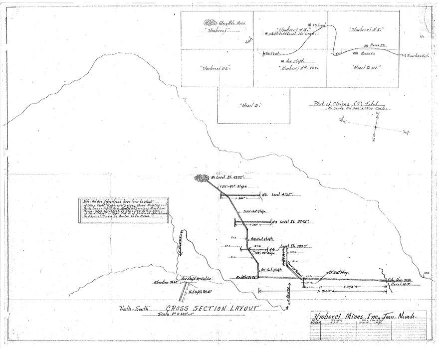
09709440014951475084149.jpg
Kalley Mine, Clark Mountain District, Clark Mts, San Bernardino County, California, USA

ca 1954

Released to the public domain via USGS DMEA Program. For more information, see http://minerals.usgs.gov/dockets/

http://minerals.usgs.gov/dockets/scans/ca/dmea/3506_DMEA.pdf
Photo ID: 626412     Uploaded by: Russell Hartill   Upload date: 2014-07-21   View Count: 297    Status: Public galleries    Type: Photo - 9600×7616 (73.1 Mpix)

Location map of mine

02347940014948275854122.jpg
Kalley Mine, Clark Mountain District, Clark Mts, San Bernardino County, California, USA

ca 1954

Released to the public domain via USGS DMEA Program. For more information, see http://minerals.usgs.gov/dockets/

http://minerals.usgs.gov/dockets/scans/ca/dmea/3506_DMEA.pdf
Photo ID: 626409     Uploaded by: Russell Hartill   Upload date: 2014-07-21   View Count: 425    Status: Public galleries    Type: Photo - 6467×4212 (27.2 Mpix)
Page 1 of 5 (1 to 10 of 45 total)
1 2 3 4 5
 
矿物 and/or 产地  
Mindat Discussions Facebook Logo Instagram Logo Discord Logo
版权所有© mindat.org1993年至2024年,除了规定的地方。 Mindat.org全赖于全球数千个以上成员和支持者们的参与。
隐私政策 - 条款和条款细则 - 联络我们 - Report a bug/vulnerability Current server date and time: 2024.4.24 11:05:17
Go to top of page