| Locality | Latitude | Longitude | Distance | Bearing |
|---|
| Trewethen Mine, St Kew, Cornwall, England, UK | 50° 34' 28" N | 4° 45' 29" W | 0.0km (0.0 miles) | |
| Pengenna Mine, St Kew, Cornwall, England, UK | 50° 34' 35" N | 4° 45' 26" W | 0.2km (0.1 miles) | |
| South Treburgett Mine, St Teath, Cornwall, England, UK | 50° 34' 46" N | 4° 44' 46" W | 1.0km (0.6 miles) | |
| Trewane Mine (Wheal Sarah), Trewane United Mine, St Kew, Cornwall, England, UK | 50° 34' 40" N | 4° 46' 22" W | 1.1km (0.7 miles) | |
| Old Treburgett Mine, St Teath, Cornwall, England, UK | 50° 34' 59" N | 4° 44' 51" W | 1.2km (0.7 miles) | |
| Trelill Quarry, St Kew, Cornwall, England, UK | 50° 33' 59" N | 4° 46' 10" W | 1.2km (0.8 miles) | |
| Treburgett Mine, St Teath, Cornwall, England, UK | 50° 35' 9" N | 4° 44' 47" W | 1.5km (0.9 miles) | |
| Tregeare Consols (Wheal Prockter), Trewane United Mine, St Kew, Cornwall, England, UK | 50° 35' 3" N | 4° 46' 39" W | 1.7km (1.1 miles) | |
| Whitewell Mine, St Teath, Cornwall, England, UK | 50° 35' 22" N | 4° 44' 43" W | 1.9km (1.2 miles) | |
| Treroosel Mine (Trerosal Mine), St Teath, Cornwall, England, UK | 50° 35' 38" N | 4° 44' 49" W | 2.3km (1.4 miles) | |
| Pendogget Mine, St Kew, Cornwall, England, UK | 50° 35' 4" N | 4° 47' 55" W | 3.1km (1.9 miles) | |
| Treore Mine, St Endellion, Cornwall, England, UK | 50° 35' 10" N | 4° 47' 55" W | 3.1km (2.0 miles) | |
| Poltreworgey Mine, St Endellion, Cornwall, England, UK | 50° 34' 47" N | 4° 48' 24" W | 3.5km (2.2 miles) | |
| Bounds Cliff, St Endellion, Cornwall, England, UK | 50° 35' 50" N | 4° 47' 42" W | 3.6km (2.2 miles) | |
| Barrett 's Zawn, St Teath, Cornwall, England, UK | 50° 36' 6" N | 4° 47' 17" W | 3.7km (2.3 miles) | |
| Bodannon Mine, Trewetha, St Endellion, Cornwall, England, UK | 50° 35' 9" N | 4° 48' 46" W | 4.1km (2.5 miles) | |
| Trevinnick Mine, St Kew, Cornwall, England, UK | 50° 34' 17" N | 4° 49' 3" W | 4.2km (2.6 miles) | |
| Tresungers Mine (Rose Mine; Wheal Arthur), Port Isaac, St Endellion, Cornwall, England, UK | 50° 34' 59" N | 4° 49' 10" W | 4.4km (2.8 miles) | |
| Wheal Boys (Trewetha Mine; Old Trewetha Mine), Port Isaac, St Endellion, Cornwall, England, UK | 50° 35' 6" N | 4° 49' 9" W | 4.4km (2.8 miles) | |
| Trewetha, St Endellion, Cornwall, England, UK | 50° 35' 11" N | 4° 49' 9" W | 4.5km (2.8 miles) | |
| Tresungers Point (incl. Tartar Cove), St Endellion, Cornwall, England, UK | 50° 35' 44" N | 4° 48' 52" W | 4.6km (2.9 miles) | |
| Great Onslow Consols (Great Michell Consols), St Breward, Cornwall, England, UK | 50° 34' 1" N | 4° 41' 20" W | 5.0km (3.1 miles) | |
| Port Gaverne, St Endellion, Cornwall, England, UK | 50° 35' 36" N | 4° 49' 27" W | 5.1km (3.2 miles) | |
| Wheal Thomas, Port Isaac, St Endellion, Cornwall, England, UK | 50° 35' 16" N | 4° 49' 41" W | 5.1km (3.2 miles) | |
| Trerubies Cliff, Treligga, St Teath, Cornwall, England, UK | 50° 37' 11" N | 4° 46' 26" W | 5.2km (3.2 miles) | |
| Tregardock Mine (Tregarget Mine), Treligga, St Teath, Cornwall, England, UK | 50° 37' 23" N | 4° 46' 10" W | 5.4km (3.4 miles) | |
| Port Isaac, St Endellion, Cornwall, England, UK | 50° 35' 37" N | 4° 49' 47" W | 5.5km (3.4 miles) | |
| Port Isaac Cliffs, Port Isaac, St Endellion, Cornwall, England, UK | 50° 35' 43" N | 4° 49' 49" W | 5.6km (3.5 miles) | |
| Delabole Slate Quarry, St Teath, Cornwall, England, UK | 50° 37' 19" N | 4° 43' 18" W | 5.9km (3.7 miles) | |
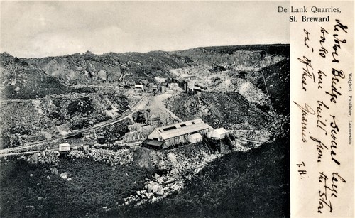
| De Lank Quarry, St Breward, Cornwall, England, UK | 50° 32' 52" N | 4° 40' 50" W | 6.3km (3.9 miles) | |


Tresungers Mine, Port Isaac, St Endellion, Cornwall, England, UK