| Locality | Latitude | Longitude | Distance | Bearing |
|---|
| Falling Springs, Deer Creek, Carroll County, Indiana, USA | 40° 33' 34" N | 86° 41' 39" W | 0.0km (0.0 miles) | |
| Deer Creek, Wabash County, Indiana, USA | 40° 34' 29" N | 86° 40' 52" W | 2.0km (1.3 miles) | |
| Delphi, Carroll County, Indiana, USA | 40° 35' 15" N | 86° 40' 30" W | 3.5km (2.2 miles) | |
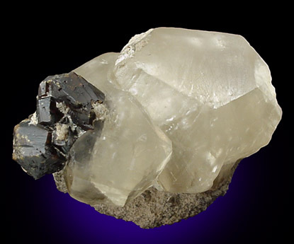
| Delphi Limestone Co. Quarry, Delphi, Carroll County, Indiana, USA | 40° 35' 56" N | 86° 41' 12" W | 4.4km (2.7 miles) | |
| Sphalerite Occurrence Z55, Carroll County, Indiana, USA | 40° 36' 29" N | 86° 39' 50" W | 6.0km (3.7 miles) | |
| Carroll County Highway Department, Carroll County, Indiana, USA | 40° 32' 48" N | 86° 31' 23" W | 14.5km (9.0 miles) | |
| Lafayette (stone) Martian meteorite, Lafayette, Tippecanoe County, Indiana, USA | 40° 25' 0" N | 86° 52' 59" W | 22.5km (14.0 miles) | |
| Rostone Corporation Lafayette Operations, Tippecanoe County, Indiana, USA | 40° 25' 12" N | 86° 53' 35" W | 22.9km (14.2 miles) | |
| Keeport Quarry, Cass County, Indiana, USA | 40° 45' 38" N | 86° 46' 54" W | 23.5km (14.6 miles) | |
| White County Highway Department, White County, Indiana, USA | 40° 45' 0" N | 86° 52' 23" W | 26.0km (16.2 miles) | |
| Deer Creek, Carroll County, Indiana, USA | 40° 36' 51" N | 86° 23' 27" W | 26.3km (16.3 miles) | |
| Logansport Quarry, Cass County, Indiana, USA | 40° 44' 17" N | 86° 26' 0" W | 29.6km (18.4 miles) | |
| Sphalerite Occurrence Z76, Cass County, Indiana, USA | 40° 45' 39" N | 86° 24' 0" W | 33.4km (20.8 miles) | |
| Clinton County Highway Department, Clinton County, Indiana, USA | 40° 16' 54" N | 86° 30' 54" W | 34.4km (21.4 miles) | |
| Vulcan Materials Company Quarry - Monon Plant, Monon, White County, Indiana, USA | 40° 50' 30" N | 86° 52' 59" W | 35.2km (21.9 miles) | |
| Logansport, Cass County, Indiana, USA | 40° 45' 14" N | 86° 21' 29" W | 35.7km (22.2 miles) | |
| Engineering Aggregates Corp. Quarry (Plant No. 1), Logansport, Cass County, Indiana, USA | 40° 43' 54" N | 86° 20' 16" W | 35.7km (22.2 miles) | |
| Cass County Highway Department, Cass County, Indiana, USA | 40° 45' 24" N | 86° 21' 29" W | 35.8km (22.3 miles) | |
| Engineering Aggregates Corp. Quarry (Plant No. 2), Logansport, Cass County, Indiana, USA | 40° 45' 24" N | 86° 21' 29" W | 35.8km (22.3 miles) | |
| Monon Crushed Stone Company Quarry, Monon, White County, Indiana, USA | 40° 52' 0" N | 86° 52' 45" W | 37.5km (23.3 miles) | |
| France Stone Co. Quarry, Logansport, Cass County, Indiana, USA | 40° 45' 34" N | 86° 16' 51" W | 41.4km (25.7 miles) | |
| Rostone Pit, Fountain County, Indiana, USA | 40° 19' 57" N | 87° 7' 56" W | 44.9km (27.9 miles) | |
| Yeoman Stone Quarry (Kokomo Quarry), Howard County, Indiana, USA | 40° 28' 23" N | 86° 10' 14" W | 45.3km (28.2 miles) | |
| Ward Stone Company, Pulaski County, Indiana, USA | 40° 56' 53" N | 86° 53' 17" W | 46.2km (28.7 miles) | |
| Vulcan Materials Company Quarry - Francesville Plant, Francesville, Pulaski County, Indiana, USA | 40° 57' 39" N | 86° 53' 8" W | 47.5km (29.5 miles) | |
| Howard County Highway Department, Howard County, Indiana, USA | 40° 29' 12" N | 86° 7' 59" W | 48.1km (29.9 miles) | |
| Francesville, Pulaski County, Indiana, USA | 40° 59' 7" N | 86° 52' 46" W | 49.8km (31.0 miles) | |
| Mill Creek Stone & Gravel Corporation (Bunker Hill Quarry; Mill Creek Quarry & Mill-Plt. No. 2), Miami County, Indiana, USA | 40° 40' 15" N | 86° 6' 21" W | 51.2km (31.8 miles) | |
| Bunker Hill, Miami County, Indiana, USA | 40° 39' 37" N | 86° 6' 9" W | 51.2km (31.8 miles) | |
| Big Pipe Creek, Bunker Hill, Miami County, Indiana, USA | 40° 40' 18" N | 86° 6' 13" W | 51.4km (31.9 miles) | |
Minerals recorded nearby (within 20 km)
Rock types recorded nearby (within 20 km)
Entries shown in red are rocks recorded for this region.


Delphi Limestone Co. Quarry, Delphi, Carroll County, Indiana, USA