Legendary Leadville, Colorado
Last Updated: 9th May 2020By Nathalie Brandes
The rocks around Leadville, Colorado host one of the largest lead-zinc-silver deposits in the world (Wallace, 1993). For over 130 years, through economic disruptions, labour issues, volatile metal markets, and the inclement weather of the high altitude, mines extracted ore from these rich deposits.
Leadville is located on the west flank of the Mosquito Range at an elevation of 3090 metres (10,150 feet). It is approximately 150 kilometres (96 miles) southwest of Denver (Maslyn, 1996). The city can be reached by US 24, but at one time three railways served the city as well (Blair, 1980). The terrain is mountainous with many areas forested with ponderosa pine and Douglas fir (Wallace, 1993).
The oldest rocks in the Leadville area are Proterozoic (1.7 Ga) granite that is overlain by Late Cambrian to Pennsylvanian marine sediments. The sediments include limestone, dolomite, sandstone, and quartzite that was uplifted and eroded in the Pennsylvanian resulting in some karst development in the carbonate rocks (Wallace, 1993; Maslyn, 1996). During the Laramide Orogeny, the area was again uplifted and several granodiorite to monzogranitic intrusions were emplaced (Bookstrom, 1990; Wallace, 1993). Another episode of intrusive activity affected the region around 43 to 39 Ma that resulted in ore formation. Intrusions were mostly sills, but also some dykes and stocks (Wireman et al., 2006). During the Tertiary, Rio Grande Rift extension caused the development of the Arkansas graben as well as regional doming that helped bring ores to the surface (Wallace, 1993). The ore deposits and host rocks are cut by numerous faults, both normal and reverse, with displacement of 10s to 100s of metres (Tweto, 1960; Tweto, 1968; Thompson and Arehart, 1990). During the Quaternary, the landscape was modified by glacial processes (Behre, 1953; Tweto, 1974).
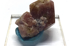
There are three basic ore deposit types in Leadville—primary, secondary, and placer. Of these, the most straightforward are the placers, which were formed by erosion of bedrock deposits in the Quaternary. Characterising the primary deposits of the Leadville area is complex and confusing. Still today there is debate concerning the processes of formation. Some investigators (Callahan, 1964; DeVoto, 1983) have considered the deposits to be a variety of Mississippi Valley-type deposit. The mineral composition and temperature of formation, however, is different and thus most geologists consider them to be a separate type (Ohle, 1991). Thompson and Arehart (1990) subdivide the primary ore deposits into three types: magnetite-serpentinite near the Breece Hill Stock, the Sherman-type barite-silver carbonate hosted, and the Leadville-type silver-lead-zinc carbonate hosted. The magnetite-serpentinite deposits were formed within 200 metres of the stock during its emplacement and were locally enriched in gold and silver (Wallace, 1993). The Sherman-type deposits fill palaeokarst features in the Leadville Dolomite (Behre, 1953; Maslyn, 1996). The Sherman-type deposits fill palaeokarst features in the Leadville Dolomite (Behre, 1953; Maslyn, 1996). The timing of mineralisation of these deposits is debated. Landis and Tschauder (1990) suggest a Pennsylvanian age, Symons and Lewchuk (2000) report a Permian age, while others support Late Cretaceous to early Tertiary timing (Johansing and Thompson, 1990). The largest ore deposits of the area are the Leadville-type replacement, or manto, ores. The ascent of mineralising fluids was impeded by impermeable rocks and the fluids were forced into the highly reactive carbonate sedimentary rocks (Wallace, 1993). The magmatic source of these fluids is not exposed, but thought to be somewhere beneath Breece Hill (Thompson and Arehart, 1990; Thompson and Beaty, 1990). Earlier investigators called these stratabound ore bodies developed at impermeable boundaries “contacts” and identified as many as eleven of them (Emmons, 1927; Ohle, 1991). The Leadville-type ore bodies have irregular dimensions, some as thick as 40 metres (125 feet), as long as 1000 metres (3300 feet), and as wide as 130 metres (500 feet) (Ohle, 1991). Pyrite, galena, and sphalerite are the most common sulphide minerals in the replacement deposits. Chalcopyrite, tennantite-tetrahedrite, magnetite, and other minor minerals are also present (Emmons et al., 1927; Thompson and Arehart, 1990). Silver is found in acanthite and argentiferous tetrahedrite. Gold is native (Tweto, 1968). Gangue minerals include manganosiderite and quartz (Wallace, 1993). Secondary ores were created through supergene enrichment when uplift and erosion related to the Rio Grande Rift lowered the water table and allowed the sulphide ores near the surface to be oxidised. In some areas, oxidation reached as deep as 300 metres (Tweto, 1968).

Mining in Leadville experienced several boom and bust cycles. The earliest known mineral exploration in the area dates to 1859, when prospectors were panning for gold in the region. The discovery of the district is attributed to Abe Lee, a member of a larger prospecting group, who found a rich pan of gold in April of 1860. According to legend, he stated, “I’ve just got California in this here pan!” The statement gave California Gulch its name. By 1861, the post office of Oro City was established in California Gulch. By 1865, the placer gold was mostly mined out (Blair 1980). In 1874, cerrucite outcrops, which proved to be argentiferous, were discovered and the next mining boom began (Blair, 1980; Wallace, 1993). By 1877, Oro City was no more and the post office was established at Leadville, which was incorporated as a town a year later. By 1879, about 20,000 people lived in and around Leadville. It was at this time that the city experienced its most remarkable days of mining. Some assays from the Robert E. Lee mine were as high as 10,306 ounces/tonne silver (Blair, 1980).This boom lasted for several years until, like many western American mining districts, the repeal of the Sherman Silver Purchase Act and the following Panic of 1893 was a major blow to the economy (Blair, 1980; Wallace, 1993). Two years later, the Western Federation of Miners arrived and in 1896 called a strike. Unfortunately, the strike became violent, forcing the governor of Colorado to order the militia to the mining district to keep the peace. During this time, the mines were closed and allowed to flood. When the strike ended in 1897, many mines did not re-open due to the cost of dewatering them. In 1899, rich zinc ores were discovered, which brought new life to the district that lasted until the Great Depression (Ohle, 1991; Blair, 1980). Although the glory days were over, mining continued in the area until 1998, when the Black Cloud Mine, a lead-zinc producer, closed (Wireman et al., 2006).
Leadville boasts a history of colourful residents. In the early 1880s gunfighter Doc Holliday dealt faro in local saloons. The famous Guggenheim family became wealthy in the smelting industry. H.A.W. Tabor made his fortune in the Leadville mines and his fame at the centre of an infamous, bigamous love triangle that captivated the American public enough to become the topic of an opera. Molly Brown, who survived the sinking of the Titanic and also became the subject of film and musical, was the wife of John J. Brown, superintendent of the Ibex Mine (Blair, 1980).
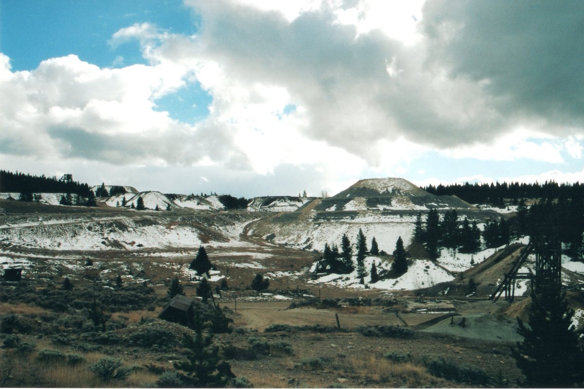
Today mining has ceased in the Leadville District, but is still very visible. Over the course of the district’s history over 2800 patented mine claims were filed. The surrounding area is marked with over 1600 prospects, 1300 shafts, and 155 adits (Wireman et al., 2006). The city itself offers a fine example of western American Victorian architecture. Walking the streets of the city is a journey into the history of a legendary mining locality.
REFERENCES
Behre, C. H., Jr., 1953, Geology and ore deposits of the west slope of the Mosquito Range: U.S. Geological Survey Professional Paper 970, 176p.
Blair, E., 1980, Leadville: Colorado’s magic city: Boulder, Colorado, Fred Pruett Books, 247p.
Bookstrom, A.A., 1990, Tectonic setting, igneous rocks, and ore deposits of the northeastern segment of the Colorado mineral belt, in Beaty, D.W., Landis, G.P., and Thompson, T.B., eds., Carbonate-hosted sulfide deposits of the central Colorado mineral belt: Economic Geology Monograph No. 7, p. 45-65.
Callahan, W.H., 1964, Paleophysiographic premises for prospecting for stratabound base metal mineral deposits in carbonate rocks: Ankara, CENTO Symposium on mining, geology, and base metals, p. 230-235.
DeVoto, R.A., 1983, Central Colorado karst-hosted lead-zinc-silver deposits (Leadville, Gilman, Aspen, and others), a late Paleozoic Mississippi valley-type district, in Kisvarsany, G., Grant, S.K., Pratt, W.P., Koenig, J.W., eds., Proceedings, International Conference on Mississippi valley-type lead-zinc deposits: Rolla, Missouri, p. 459-485.
Emmons, S.F., Irving, J.D., and Loughlin, G.F., 1927, Geology and ore deposits of the Leadville mining district, Colorado: U.S. Geological Survey Professional Paper 148, 368p.
Johansing, R.J. and Thompson, T.B., 1990, Geology and origin of Sherman-type deposits, central Colorado, in Beaty, D.W., Landis, G.P., and Thompson, T.B., eds., Carbonate-hosted sulfide deposits of the central Colorado mineral belt: Economic Geology Monograph No. 7, p. 367-394.
Landis, G.P. and Tschauder, R.J., 1990, Late Mississippian karst caves and Ba-Ag-Pb-Zn mineralization in central Colorado, Part II. Fluid inclusion, stable isotope, and rock geochemistry data and a model for ore deposition, in Beaty, D.W., Landis, G.P., and Thompson, T.B., eds., Carbonate-hosted sulfide deposits of the central Colorado mineral belt: Economic Geology Monograph No. 7, p. 339-366.
Maslyn, M., 1996, Mineralized Late-Mississippian paleokarst features and paleogeography in the Leadville, Colorado area, in The Caves and Karst of Colorado: National Speleological Society 1996 Convention Guidebook, p. 136-143.
Ohle, E.L., 1991, Lead and zinc deposits, in Gluskoter, H.J., Rice, D.D., and Taylor, R.B., eds., Economic Geology, U.S.: Boulder, Colorado, Geological Society of America, The Geology of North America, v. P-2, p. 43-62.
Symons, D.T.A. and Lewchuk, M.T., 2000, Age of Sherman-type Zn-Pb-Ag deposits, Mosquito Range, Colorado: Economic Geology, v. 95, p. 1489-1504.
Thompson, T.B., and Arehart, G.B., 1990, Geology and the origin of ore deposits in the Leadville district, Colorado: Part I. Geologic studies of orebodies and wall rocks, in Beaty, D.W., Landis, G.P., and Thompson, T.B., eds., Carbonate-hosted sulfide deposits of the central Colorado mineral belt: Economic Geology Monograph No. 7, p. 130-155.
Thompson, T.B. and Beaty, D.W., 1990, Geology and ore deposits in the Leadville district, Colorado: Part II. Oxygen, hydrogen, carbon, sulfur, and lead isotopic data and the development of a genetic model, in Beaty, D.W., Landis, G.P., and Thompson, T.B., eds., Carbonate-hosted sulfide deposits of the central Colorado mineral belt: Economic Geology Monograph No. 7, p. 156-179.
Tweto, O., 1960, Pre-ore ago of faults at Leadville, Colorado: U.S. Geological Survey Professional Paper 400-B, p. 10-11.
Tweto, O., 1968, Leadville district, Colorado, in Ridge, J.D., ed., Ore Deposits of the United States, 1933-1967 (Graton-Sales Volume): New York, American Institute of Mining, Metallurgical, and Petroleum Engineers, Inc., p. 681-705.
Tweto, O., 1974, Geologic map and sections of the Holy Cross quadrangle, Eagle, Lake, and Summit Counties, Colorado: U.S. Geological Survey Miscellaneous Investigations Series Map I-830, scale 1:24000.
Wallace, A.R., Geologic setting of the Leadville mining district, Lake County, Colorado: U.S. Geological Survey Open-file Report 93-343, 20p.
Wireman, M., Gertson, J., and Williams, M., 2006, Hydrogeologic characterization of groundwaters, mine pools, and the Leadville mine drainage tunnel, Leadville, Colorado in Barnhisel, R.I., ed., 7th International Conference on Acid Rock Drainage: Lexington, Kentucky, American Society of Mining and Reclamation, p. 2439-2469.
Leadville is located on the west flank of the Mosquito Range at an elevation of 3090 metres (10,150 feet). It is approximately 150 kilometres (96 miles) southwest of Denver (Maslyn, 1996). The city can be reached by US 24, but at one time three railways served the city as well (Blair, 1980). The terrain is mountainous with many areas forested with ponderosa pine and Douglas fir (Wallace, 1993).
The oldest rocks in the Leadville area are Proterozoic (1.7 Ga) granite that is overlain by Late Cambrian to Pennsylvanian marine sediments. The sediments include limestone, dolomite, sandstone, and quartzite that was uplifted and eroded in the Pennsylvanian resulting in some karst development in the carbonate rocks (Wallace, 1993; Maslyn, 1996). During the Laramide Orogeny, the area was again uplifted and several granodiorite to monzogranitic intrusions were emplaced (Bookstrom, 1990; Wallace, 1993). Another episode of intrusive activity affected the region around 43 to 39 Ma that resulted in ore formation. Intrusions were mostly sills, but also some dykes and stocks (Wireman et al., 2006). During the Tertiary, Rio Grande Rift extension caused the development of the Arkansas graben as well as regional doming that helped bring ores to the surface (Wallace, 1993). The ore deposits and host rocks are cut by numerous faults, both normal and reverse, with displacement of 10s to 100s of metres (Tweto, 1960; Tweto, 1968; Thompson and Arehart, 1990). During the Quaternary, the landscape was modified by glacial processes (Behre, 1953; Tweto, 1974).
There are three basic ore deposit types in Leadville—primary, secondary, and placer. Of these, the most straightforward are the placers, which were formed by erosion of bedrock deposits in the Quaternary. Characterising the primary deposits of the Leadville area is complex and confusing. Still today there is debate concerning the processes of formation. Some investigators (Callahan, 1964; DeVoto, 1983) have considered the deposits to be a variety of Mississippi Valley-type deposit. The mineral composition and temperature of formation, however, is different and thus most geologists consider them to be a separate type (Ohle, 1991). Thompson and Arehart (1990) subdivide the primary ore deposits into three types: magnetite-serpentinite near the Breece Hill Stock, the Sherman-type barite-silver carbonate hosted, and the Leadville-type silver-lead-zinc carbonate hosted. The magnetite-serpentinite deposits were formed within 200 metres of the stock during its emplacement and were locally enriched in gold and silver (Wallace, 1993). The Sherman-type deposits fill palaeokarst features in the Leadville Dolomite (Behre, 1953; Maslyn, 1996). The Sherman-type deposits fill palaeokarst features in the Leadville Dolomite (Behre, 1953; Maslyn, 1996). The timing of mineralisation of these deposits is debated. Landis and Tschauder (1990) suggest a Pennsylvanian age, Symons and Lewchuk (2000) report a Permian age, while others support Late Cretaceous to early Tertiary timing (Johansing and Thompson, 1990). The largest ore deposits of the area are the Leadville-type replacement, or manto, ores. The ascent of mineralising fluids was impeded by impermeable rocks and the fluids were forced into the highly reactive carbonate sedimentary rocks (Wallace, 1993). The magmatic source of these fluids is not exposed, but thought to be somewhere beneath Breece Hill (Thompson and Arehart, 1990; Thompson and Beaty, 1990). Earlier investigators called these stratabound ore bodies developed at impermeable boundaries “contacts” and identified as many as eleven of them (Emmons, 1927; Ohle, 1991). The Leadville-type ore bodies have irregular dimensions, some as thick as 40 metres (125 feet), as long as 1000 metres (3300 feet), and as wide as 130 metres (500 feet) (Ohle, 1991). Pyrite, galena, and sphalerite are the most common sulphide minerals in the replacement deposits. Chalcopyrite, tennantite-tetrahedrite, magnetite, and other minor minerals are also present (Emmons et al., 1927; Thompson and Arehart, 1990). Silver is found in acanthite and argentiferous tetrahedrite. Gold is native (Tweto, 1968). Gangue minerals include manganosiderite and quartz (Wallace, 1993). Secondary ores were created through supergene enrichment when uplift and erosion related to the Rio Grande Rift lowered the water table and allowed the sulphide ores near the surface to be oxidised. In some areas, oxidation reached as deep as 300 metres (Tweto, 1968).
Mining in Leadville experienced several boom and bust cycles. The earliest known mineral exploration in the area dates to 1859, when prospectors were panning for gold in the region. The discovery of the district is attributed to Abe Lee, a member of a larger prospecting group, who found a rich pan of gold in April of 1860. According to legend, he stated, “I’ve just got California in this here pan!” The statement gave California Gulch its name. By 1861, the post office of Oro City was established in California Gulch. By 1865, the placer gold was mostly mined out (Blair 1980). In 1874, cerrucite outcrops, which proved to be argentiferous, were discovered and the next mining boom began (Blair, 1980; Wallace, 1993). By 1877, Oro City was no more and the post office was established at Leadville, which was incorporated as a town a year later. By 1879, about 20,000 people lived in and around Leadville. It was at this time that the city experienced its most remarkable days of mining. Some assays from the Robert E. Lee mine were as high as 10,306 ounces/tonne silver (Blair, 1980).This boom lasted for several years until, like many western American mining districts, the repeal of the Sherman Silver Purchase Act and the following Panic of 1893 was a major blow to the economy (Blair, 1980; Wallace, 1993). Two years later, the Western Federation of Miners arrived and in 1896 called a strike. Unfortunately, the strike became violent, forcing the governor of Colorado to order the militia to the mining district to keep the peace. During this time, the mines were closed and allowed to flood. When the strike ended in 1897, many mines did not re-open due to the cost of dewatering them. In 1899, rich zinc ores were discovered, which brought new life to the district that lasted until the Great Depression (Ohle, 1991; Blair, 1980). Although the glory days were over, mining continued in the area until 1998, when the Black Cloud Mine, a lead-zinc producer, closed (Wireman et al., 2006).
Leadville boasts a history of colourful residents. In the early 1880s gunfighter Doc Holliday dealt faro in local saloons. The famous Guggenheim family became wealthy in the smelting industry. H.A.W. Tabor made his fortune in the Leadville mines and his fame at the centre of an infamous, bigamous love triangle that captivated the American public enough to become the topic of an opera. Molly Brown, who survived the sinking of the Titanic and also became the subject of film and musical, was the wife of John J. Brown, superintendent of the Ibex Mine (Blair, 1980).

Today mining has ceased in the Leadville District, but is still very visible. Over the course of the district’s history over 2800 patented mine claims were filed. The surrounding area is marked with over 1600 prospects, 1300 shafts, and 155 adits (Wireman et al., 2006). The city itself offers a fine example of western American Victorian architecture. Walking the streets of the city is a journey into the history of a legendary mining locality.
REFERENCES
Behre, C. H., Jr., 1953, Geology and ore deposits of the west slope of the Mosquito Range: U.S. Geological Survey Professional Paper 970, 176p.
Blair, E., 1980, Leadville: Colorado’s magic city: Boulder, Colorado, Fred Pruett Books, 247p.
Bookstrom, A.A., 1990, Tectonic setting, igneous rocks, and ore deposits of the northeastern segment of the Colorado mineral belt, in Beaty, D.W., Landis, G.P., and Thompson, T.B., eds., Carbonate-hosted sulfide deposits of the central Colorado mineral belt: Economic Geology Monograph No. 7, p. 45-65.
Callahan, W.H., 1964, Paleophysiographic premises for prospecting for stratabound base metal mineral deposits in carbonate rocks: Ankara, CENTO Symposium on mining, geology, and base metals, p. 230-235.
DeVoto, R.A., 1983, Central Colorado karst-hosted lead-zinc-silver deposits (Leadville, Gilman, Aspen, and others), a late Paleozoic Mississippi valley-type district, in Kisvarsany, G., Grant, S.K., Pratt, W.P., Koenig, J.W., eds., Proceedings, International Conference on Mississippi valley-type lead-zinc deposits: Rolla, Missouri, p. 459-485.
Emmons, S.F., Irving, J.D., and Loughlin, G.F., 1927, Geology and ore deposits of the Leadville mining district, Colorado: U.S. Geological Survey Professional Paper 148, 368p.
Johansing, R.J. and Thompson, T.B., 1990, Geology and origin of Sherman-type deposits, central Colorado, in Beaty, D.W., Landis, G.P., and Thompson, T.B., eds., Carbonate-hosted sulfide deposits of the central Colorado mineral belt: Economic Geology Monograph No. 7, p. 367-394.
Landis, G.P. and Tschauder, R.J., 1990, Late Mississippian karst caves and Ba-Ag-Pb-Zn mineralization in central Colorado, Part II. Fluid inclusion, stable isotope, and rock geochemistry data and a model for ore deposition, in Beaty, D.W., Landis, G.P., and Thompson, T.B., eds., Carbonate-hosted sulfide deposits of the central Colorado mineral belt: Economic Geology Monograph No. 7, p. 339-366.
Maslyn, M., 1996, Mineralized Late-Mississippian paleokarst features and paleogeography in the Leadville, Colorado area, in The Caves and Karst of Colorado: National Speleological Society 1996 Convention Guidebook, p. 136-143.
Ohle, E.L., 1991, Lead and zinc deposits, in Gluskoter, H.J., Rice, D.D., and Taylor, R.B., eds., Economic Geology, U.S.: Boulder, Colorado, Geological Society of America, The Geology of North America, v. P-2, p. 43-62.
Symons, D.T.A. and Lewchuk, M.T., 2000, Age of Sherman-type Zn-Pb-Ag deposits, Mosquito Range, Colorado: Economic Geology, v. 95, p. 1489-1504.
Thompson, T.B., and Arehart, G.B., 1990, Geology and the origin of ore deposits in the Leadville district, Colorado: Part I. Geologic studies of orebodies and wall rocks, in Beaty, D.W., Landis, G.P., and Thompson, T.B., eds., Carbonate-hosted sulfide deposits of the central Colorado mineral belt: Economic Geology Monograph No. 7, p. 130-155.
Thompson, T.B. and Beaty, D.W., 1990, Geology and ore deposits in the Leadville district, Colorado: Part II. Oxygen, hydrogen, carbon, sulfur, and lead isotopic data and the development of a genetic model, in Beaty, D.W., Landis, G.P., and Thompson, T.B., eds., Carbonate-hosted sulfide deposits of the central Colorado mineral belt: Economic Geology Monograph No. 7, p. 156-179.
Tweto, O., 1960, Pre-ore ago of faults at Leadville, Colorado: U.S. Geological Survey Professional Paper 400-B, p. 10-11.
Tweto, O., 1968, Leadville district, Colorado, in Ridge, J.D., ed., Ore Deposits of the United States, 1933-1967 (Graton-Sales Volume): New York, American Institute of Mining, Metallurgical, and Petroleum Engineers, Inc., p. 681-705.
Tweto, O., 1974, Geologic map and sections of the Holy Cross quadrangle, Eagle, Lake, and Summit Counties, Colorado: U.S. Geological Survey Miscellaneous Investigations Series Map I-830, scale 1:24000.
Wallace, A.R., Geologic setting of the Leadville mining district, Lake County, Colorado: U.S. Geological Survey Open-file Report 93-343, 20p.
Wireman, M., Gertson, J., and Williams, M., 2006, Hydrogeologic characterization of groundwaters, mine pools, and the Leadville mine drainage tunnel, Leadville, Colorado in Barnhisel, R.I., ed., 7th International Conference on Acid Rock Drainage: Lexington, Kentucky, American Society of Mining and Reclamation, p. 2439-2469.
Article has been viewed at least 883 times.


Discuss this Article


California Gulch, Iron Hill, Lake County, Colorado, USA