| Locality type: | Diggings |
| Classification |
|---|
|
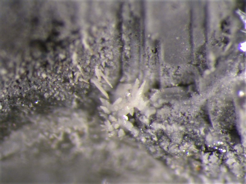
| Species: | Anglesite |
| Formula: | PbSO4 |
| Confirmation |
|---|
|
| Validity: | Confirmed |
| Confirmation Methods: | Visually Identified |
| Associated Minerals Based on Photo Data: |
|---|
|
| Galena | ⓘ1 photo of Anglesite associated with Galena at this locality. |
| Data |
|---|
|
| Mineral Data: | Click here to view Anglesite data |
| Locality Data: | Click here to view SW cut, Otto Mountain, Baker, Soda Mountains, Silver Lake Mining District, San Bernardino County, California, USA |
| Data Identifiers |
|---|
|
| Mindat Occurrence Record ID: | 960501 |
| Long-form Identifier: | 1:3:960501:5 |
| GUID (UUID V4): | b4bf1586-5844-4ef4-97b5-6f1a568c05a0 |
| Nearest other occurrences of Anglesite |
|---|
|
|
| 0.5km (0.3 miles) | ⓘBird Nest E3, Otto Mountain, Baker, Soda Mountains, Silver Lake Mining District, San Bernardino County, California, USA |
| 0.5km (0.3 miles) | ⓘBird Nest drift, Otto Mountain, Baker, Soda Mountains, Silver Lake Mining District, San Bernardino County, California, USA |
| 0.5km (0.3 miles) | ⓘAga Mine, Otto Mountain, Baker, Soda Mountains, Silver Lake Mining District, San Bernardino County, California, USA |
| 0.6km (0.4 miles) | ⓘOtto Mountain, Baker, Soda Mountains, Silver Lake Mining District, San Bernardino County, California, USA |
| 0.9km (0.6 miles) | ⓘNE2 vein, Otto Mountain, Baker, Soda Mountains, Silver Lake Mining District, San Bernardino County, California, USA |
| 9.9km (6.2 miles) | ⓘB-Site, Blue Bell Mine, Zzyzx, Soda Mountains, Silver Lake Mining District, San Bernardino County, California, USA |
| 10.0km (6.2 miles) | ⓘBlue Bell Mine, Zzyzx, Soda Mountains, Silver Lake Mining District, San Bernardino County, California, USA |
| 10.0km (6.2 miles) | ⓘUpper 2A-Site, Blue Bell Mine, Zzyzx, Soda Mountains, Silver Lake Mining District, San Bernardino County, California, USA |
| 41.1km (25.5 miles) | ⓘShadow Mountain group (Gold Hill claim group; Glory claim group; Yucca Lilly claim group; Foster Mines; Grey Copper Mine; Balboa claim group), Shadow Mountain, Shadow Mts [1], San Bernardino County, California, USA |
| 49.5km (30.7 miles) | ⓘMohawk Mine, Mohawk Hill, Clark Mountain District (Clark District), Clark Mts (Clark Mountain Range), San Bernardino County, California, USA |
| References |
|---|
|
|
| Reference Search (possible matching items) |
|---|
 | | Book (edition) | | for the Wall delimits exactly the metalliferous mining field. Lead may indeed have been produced here...and the W Beaumont Con1pany. The heyday of lead mining seemed to be over with the demise of these concerns...the dales country, the remains of a long-standing mining industry give character t() the attractive fellside...Other publications of the Survey dealing with this district and ad_joinin_g districts BOOKS Memoirs Geology...ography 1 Subdivisions of the field 3 History of mining in outline References 6 Metasomatic deposits and |
|


SW cut, Otto Mountain, Baker, Soda Mountains, Silver Lake Mining District, San Bernardino County, California, USA