 | | Journal (article/letter/editorial) | | as well. Cuprite and malachite. INDIA MEXICO Dendrites Eastonite Drs. A . T . Rao and P. P. Rao from..." The same seems to be true for dendrites. The photograph of dendrites from Astillero used to be for my...my own crusade against pyrolusite dendrites. I received the specimen many years ago marked "pyrolusite..."pyrolusite." However, these dendrites are brownish-black, not pure black as y o u would expect pyro lusite to...form! I n their article, "Mineralogy of Manganese Dendrites and Coatings" (American Mineralogist, volume |  | | Book (volume) | | Mineralogy by Vandall T. King and Eugene E. Foord Maine Geological Survey DEPARTMENT OF CONSERVATION Walter...Resources Information, Maine Geological Survey Walter A. Anderson, State Geologist Maine Geological Survey...DEPARTMENT OF CONSERVATION 1994 Copyright ©1994 by the Maine Geological Survey, Department of Conservation. All...Cover photograph: Fluorapatite, Pulsifer quarry, Auburn, Maine (2.2 cm specimen), Harvard Mineralogical...Wendell E. Wilson, ©1985. The laws and policies of Maine and the United States prohibit discrimination in |  | | Book (volume) | | 0 n101ercai o of Maine j f·~ ....__ :,,. . - .._"' ..;. .. ~ L-- -~ \. • .J_..::.; I Volume...History, Gems, and Geology edited by Vandall T. King Maine Geological Survey DEPARTMENT OF CONSERVATION Robert...Robert G. Marvinney, State Geologist of Maine Volume 2: Mining History, Gems, and Geology Edited by...Resources Information, Maine Geologi,cal Survey Robert G Marvinney, State Geologist Maine Geological Survey...DEPARTMENT OF CONSERVATION 2000 Copyright ©2000 by the Maine Geological Survey, Department of Conservation. All |  | | Journal (article/letter/editorial) | | Montana’s production of copper, coal, gold, lead, manganese, phosphate, silver, talc, vermiculite, and zinc...Indian Queen mine ca. 1905 at Farlin, Beaverhead County. 208 ROCKS & MINERALS Downloaded by [University...mines at Butte in Silver Bow County and the Black Pine mine in Granite County have produced many fine crystal...Beaverhead County, the pegmatites of Jefferson County, and the Snowbird mine in Mineral County continue...Highlands Centennial Nugget in 1989 in Silver Bow County. The seventh largest gold nugget found in Montana; |  | | Book (volume) | | Dahlonega Co. and Rabum Co., and the McDuffie County Belt extending through portions of McDuffie, Warren...Sphalerite. BALDWIN COUNTY MILLEDGEVILLE, at state farmjasper. BANKS COUNTY COMMERCE, along Hwy. 59...along adjoining Co. linerock crystal. BARROW COUNTY WINDER, along rd. to Jefferson and 1½ mi. inside...Guide for Rock Hounds in the United States BARTOW COUNTY AREA, Saltpeter Cave, as floatjasper. CARTERSVILLE:...mines, as important producersBarite, Manganese, ocher. Manganese deposits have a wide geographic distribution |  | | Book (volume) | | 600 to 800 feet thick in the north. ALEXANDER COUNTY FAYVILLE, area stream gravels⎯agate, jasper, rare...⎯agate, jasper; d RR siding of Clay⎯agate. CALHOUN COUNTY AREA, shores of the Mississippi R., in the Warsaw...crystals). CRAWFORD COUNTY PALESTINE, area deposits⎯Siderite. EDWARDS COUNTY AREA, T. 1 S, R. 10 E...E, regional deposits⎯Siderite. FULTON COUNTY FARMINGTON, W 6 mi. on Rte. 116 to the Rapatee No. 5 strip...mine⎯pyritized gastropods (Pennsylvanian age). GRUNDY COUNTY AREA: c Regional rd. and RR cuts and banks of Mason |  | | Book (volume) | | 600 to 800 feet thick in the north. ALEXANDER COUNTY FAYVILLE, area stream gravels⎯agate, jasper, rare...⎯agate, jasper; d RR siding of Clay⎯agate. CALHOUN COUNTY AREA, shores of the Mississippi R., in the Warsaw...crystals). CRAWFORD COUNTY PALESTINE, area deposits⎯Siderite. EDWARDS COUNTY AREA, T. 1 S, R. 10 E...E, regional deposits⎯Siderite. FULTON COUNTY FARMINGTON, W 6 mi. on Rte. 116 to the Rapatee No. 5 strip...mine⎯pyritized gastropods (Pennsylvanian age). GRUNDY COUNTY AREA: c Regional rd. and RR cuts and banks of Mason |  | | Book (volume) | | cut purplish pink elbaite tourmaline (30.89 ct), Maine; round brilliant red-orange spessartine garnet (16...Colorado; colorless scheelite (19.66 ct), Kern County, California; octagonal step cut violetish pink...Vivid blue matched benitoite gems from San Benito County, California, consisting of 52 benitoites and 75...Dosen ONN/ QBI96-40247 Trade Distribution by Mountain Press Publishing Company P.O. Box 2399, Missoula...Cantlin, Ellis, [D; Jeannette B. Carillo, Gem Center USA, EI Paso, TX; Gary Christopher, The Prospectors Cache |  | Collins, Donley S., Cobban, Robert R., Foord, Eugene E., Murphy, Jack A. (1989) Bibliography for update and revision of U.S.G.S. Bulletin 1114, Minerals of Colorado -- a 100 year record, by Edwin B. Eckel, Part A - Paper copy --Bibliography data file disks. Open-File Report Vol. 1989 (89-206) US Geological Survey doi:10.3133/ofr89206a | Report (issue) | | geology of the east inlet area, southwestern Rocky Mountain Park, Colorado: Golden, Colorado School of Mines...Beryllium deposits of the Mount Antero region, Chaffee County, Colorado: U.S. Geological Survey Trace Element...Beryllium deposits of the Mount Antero region, Chaffee County, Colorado: U.S. Geological Survey Bulletin 982-D...1974, Murataite, a new complex oxide from El Paso County, Colorado: American Mineralogist, v. 59, nos. 1-2...Gate Canyon and Ralston Creek areas, Jefferson County, Colorado: U.S. Geological Survey Circular 320 |  | | Thesis/Dissertation | | a mineralogic mapping technique in the Italian Mountain area, Colorado Item Type text; Thesis-Reproduction...A MINERALOGIC MAPPING TECHNIQUE IN THE ITALIAN MOUNTAIN AREA, COLORADO By Henry Albert Truebe A Thesis...APPENDIX C: DESCRIPTIVE MINERALOGY OF THE ITALIAN MOUNTAIN AREA . . ............. .....................,... Location and tectonic setting of the Italian Mountain area in Colorado. . . . . . . . . . : ..........interpretation of the geology of the \ Italian Mountain a r e a ............ .. .. / .............. 5 |  | | Book | | 11ne 2; ••• Amph1bo1ite--see Bolton, Worcester County M1nera1 Loca11t1es. page 85 ••• 11.8 3~ter cerium...•••••••••••••••••'.' •.••.•••• 2--6 Barn.table County ro •• il Localiti ••••••••••••••••••••••••••••...Localit1e•••••••••••••••••••••••••••• 21 Br1.tol County Mineral Localit1 ••••••••••••••••••••••••••••••...24--25 Dukes County Mineral Loeal1tiea •••••••••••••••••••••••••••••• 26--21 Duk •• County Fo.sil Loeal1tie...Local1t1es •••••••••••••••••••••••••••••• 29--3? Bs.ex County Fo ••1l Localit1e •••••••••••••••••••••••••••••••• |  | | Report (volume) | | Umpleby.... The Yellow Pine mining district, Clark County, Nev., by J. M. Hill...... Survey publications...zinc.................................. IRON AND MANGANESE: Preliminary report on the red iron ores of east............... Survey publications on iron and manganese ores........................ ALUMINUM ORES: Alunite...STRUCTURAL MATERIALS, ETC.: The Aberdeen granite quarry, near Gunnison, Colo., by J. F. Hunter.... Ornamental...sulphate in the Carrizo Plain, San Luis Obispo County, Cal., by U.S. Gale........................... |  | | Report (volume) | | October 1936. Ky., February 1930. La., March 1931. Maine, September 1935. Md., April 1929. Mass., April... 5 in., inch or inches. Circ., Circular. Co., County or Company. Indus., Industrial. Inst., Institute...Engineers. ms., manuscript. Eo., Eocene. Mtn, Mountain. equiv., equivalent. Mtns, Mountains. est., estimated...basal memb. of Howard Is. in southern Kans., from Greenwood Co. southward. Where it is absent, as in N. Kans...Named for Aarde farm, sec. 4, T. 26 S., R. 11 E., Greenwood Co. Aaron slate. Pre-Cambrian : Central southern |  | | Report (volume) | | .............. ^...................... 82 Lee Mountain mine................. ^...........................'........................................... Uncle Sam mine..........................................Stratified andesite breccias forming scarp on Cliff Mountain; B, Jointing in-granite south of Boulder........the area lies within Jefferson County, a part within Lewis and Clark County, and that part west of the Continental...Continental Divide in Powell County. A considerable number of organized and unorganized mining districts |  | | Report (issue) | | necessary to consider the general relations of the mountain ranges in the adjacent portions of California...THE KLAMATH MOUNTAINS. GENERAL RELATIONS. The mountain belt of the Pacific coast in California and Oregon...ranges appear to meet, there is a distinct group of mountain ridges and peaks extending from a point north...known of the early geologic history of the Klamath Mountain region, yet it is evident that in pre-Devonian...intercalated crystalline limestones of South Fork Mountain and the Salmon Mountains north of Weaverville |  | | Book | | foraminifera test. Marlbrook Marl, Taylor Group, Howard County, Arkansas. X 40. (SEM) . 1 2 A PICTORIAL GUIDE...Cretaceous to Early Middle Eocene. Navarroan Group, Hunt County, Texas. Closeup specimen from the Vincentown Formation...Navesink Formation, Atlantic Highlands, Monmouth County, New Jersey. X 60. (SEM) . 1-4. Pennsylvanian....shows spiraled chambers. Virgilian, Topeka, Shawnee County, Kansas. X 10. 1-5. Pennsylvanian. Fusulina sp...the Middle Pennsylvanian ( Desmoinesian) , Henry County, Missouri. X 17. ( SEM). 1-6. Eocene. Nummulites |  | | Report (issue) | | Cross section of Front Range showing tilting of mountain front___________________________________________...Douglas County except for a small area northwest of the South Platte River that is in Jefferson County. The...67 from the south and 75 and 221 from the north. County and U.S. Forest Service roads, logging roads, and...quadrangle. Sedimentary rocks crop out east of the mountain front; the more resistant units form ridges parallel...Fountain formation, dips northeast away from the mountain front and unconformably overlies the Precambrian |  | | Report (issue) | | Districts ....................... 49 4.1 Bald Mountain Mining District .............. 49 4.11 Introduction...History of the Bald Mountain District ....... 49 4.13. Geology of the Bald Mountain Mining District ...77 Figure 9. Cross-Section Through Ragged Top Mountain ....... 143 Figure 7. Figure 10. Idealized...pocket Plate 9. Lower Contact Zone Workings, Bald Mountain Mining District ...................... in pocket...pocket Intermediate Zone Workings, Bald Mountain Mining District ...................... in pocket Upper |  | | Report (issue) | | Wailes Bluff, St. Marys County, Md______ 25. Langleys Bluff, St. Marys County, Md____ FIGURE 1. Index...are included in the typical Frontier of Lincoln County, Wyo., where the entire formation is pre-Niobrara...14 E., and 1 mile east of Desert station, Emery County, Utah. Plate 1, Figures 5-18 Genus BACULITES Lamarck...part of Mancos shale near Desert station, Emery County, Utah. B. asper Morton includes small shells with...proportionately. The specific name is derived from Park County, Wyo., in which the type locality' occurs. Family |  | | Report (issue) | | shown by lignite bed in southeastern part of Ward County ___ _________________ Dip of Fort Union formation...mapped area. _ _ _ _ Inferred structure in Kidder County----------Structure inferred from the location of...__________-__-___-_-----------Possible structure of the Bottineau County gas field..- ___.____.__-----------_---------Possible...urke County- ___________---___--------_--Mountrail County--..--..------------------Ward County...---...Renville County ----_--_------_---_--______ Bottineau County._.__---_-_-_--___--_______ McHenry County---- |  | | Journal (issue) | | for complete publication list •tel: 918-493-3361 • USA: 800-865-9765 • fax: 918-493-2093 Volume 66 November...Columbia. Canada 8 . CHARLOTTE SCHREIBER Green Mountain. Nonh Carolina FREDERIC L. SCHWAB Washington and...P.O. Box 455 l Houston, TX 772 I 0-4551 Rocky Mountain OR. JOHN W. ROBINSON Snyder Oil Corporation 1625...Later-stage crosscutting fractures associated with manganese dendrites and ferroan staining luminescence bright...EDS.• 1989, The Prec.ambrian-{:ambrian Boundary: Oxford Monographs on Geology and Geophysics. Clarendon |
|
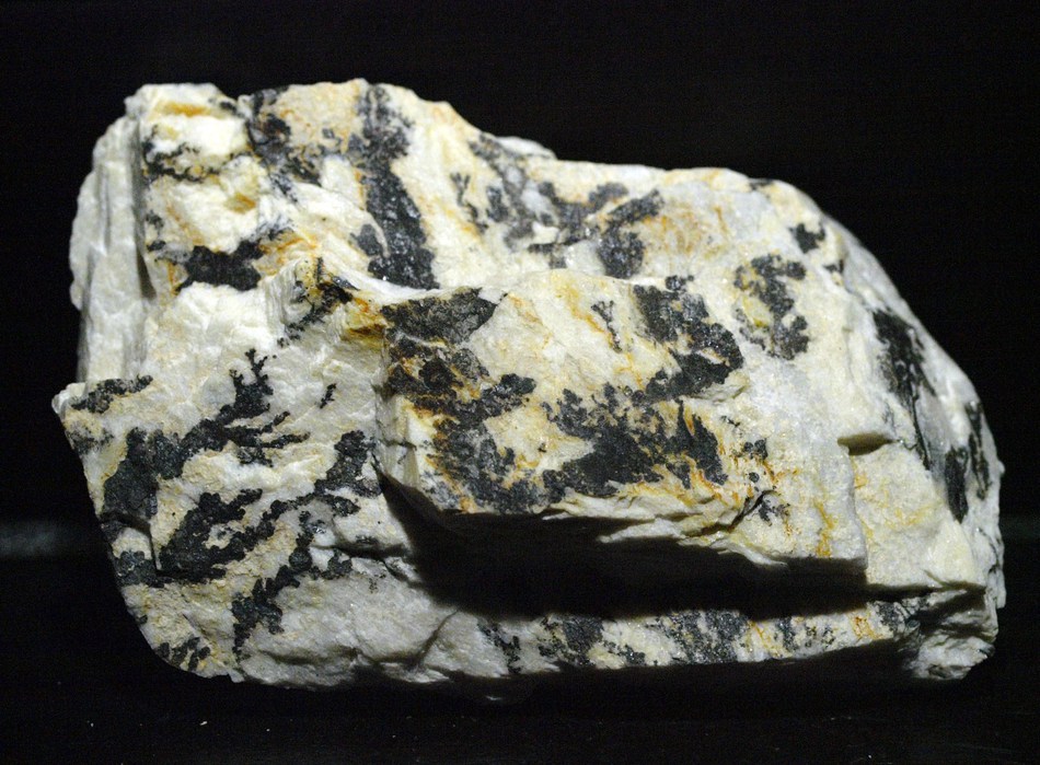


Emmons Quarry, Uncle Tom Mountain, Greenwood, Oxford County, Maine, USA