| Locality type: | Road Cutting |
| Classification |
|---|
|
| Species: | Sphalerite |
| Formula: | ZnS |
| Formation: | Secondary |
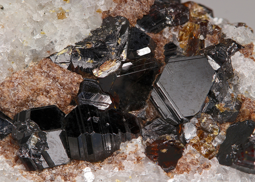
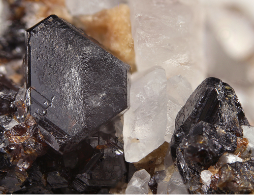
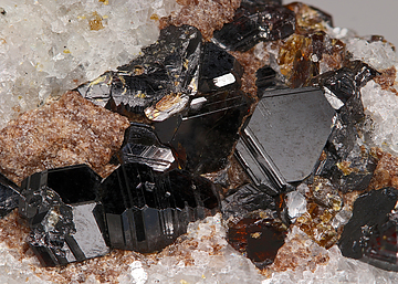
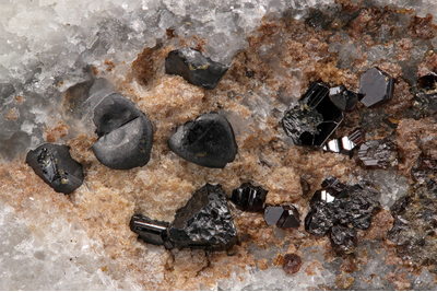
| Comments: | As micro-crystals in voids with clay in a brecciated marble matrix. Crystals show a variety of habits including polysynthetically twinned one similar to those from Thomaston Dam (misidentified as wurtzite). |
| Habit: | tetrahedral, polysynthetically twinned |
| Colour: | black, yellow-brown |
| Quality for species: | Good crystals or rich for species - important (!) |
| Confirmation |
|---|
|
| Validity: | Believed Valid |
| Associated Minerals Based on Photo Data: |
|---|
|
| Calcite | ⓘ1 photo of Sphalerite associated with Calcite at this locality. |
| Data |
|---|
|
| Mineral Data: | Click here to view Sphalerite data |
| Locality Data: | Click here to view U. S. Route 7 Expressway (Danbury line to Iron Works District), Brookfield, Fairfield County, Connecticut, USA |
| Photo Gallery | View Gallery (2 photos) |
| Data Identifiers |
|---|
|
| Mindat Occurrence Record ID: | 656991 |
| Long-form Identifier: | 1:3:656991:4 |
| GUID (UUID V4): | 19cb1124-58bc-4d29-850e-719a589fb35d |
| Nearest other occurrences of Sphalerite |
|---|
|
|
| 2.0km (1.2 miles) | ⓘOld lead mine, Brookfield, Fairfield County, Connecticut, USA |
| 6.7km (4.2 miles) | ⓘNorth Street mall, Danbury, Fairfield County, Connecticut, USA |
| 9.9km (6.1 miles) | ⓘSandy Hook gold mine (Blackwell's mine), Sandy Hook, Newtown, Fairfield County, Connecticut, USA |
| 13.9km (8.6 miles) | ⓘRoxbury Iron Mine (Shepaug Iron Company Mine; Shepaug Spathic Iron and Steel Company Mine), Mine Hill (Ore Hill), Roxbury, Litchfield County, Connecticut, USA |
| 14.1km (8.8 miles) | ⓘRockside Quarry (Mine Hill Quarry), Mine Hill (Ore Hill), Roxbury, Litchfield County, Connecticut, USA |
| 16.5km (10.2 miles) | ⓘO & G Southbury Quarry (Silliman Quarry; O & G No. 2 Quarry), Orenaug Hills, Woodbury, Litchfield County, Connecticut, USA |
| 18.1km (11.3 miles) | ⓘRidgefield Silver Mine, Ridgefield, Fairfield County, Connecticut, USA |
| 19.2km (11.9 miles) | ⓘLane's Mine (Lane's Lead and Silver Mine; Elm Street), Monroe, Fairfield County, Connecticut, USA |
| 20.0km (12.5 miles) | ⓘStevenson Mine (Burke's Copper Mine), Oxford, New Haven County, Connecticut, USA |
| 20.7km (12.9 miles) | ⓘFillow Quarry (Branchville Quarry; Branchville Mica Mine; Smith Mine), Branchville, Redding (Reading), Fairfield County, Connecticut, USA |
| References |
|---|
|
|


U. S. Route 7 Expressway, Brookfield, Fairfield County, Connecticut, USA