 | | Report (issue) | | TALC MINES, PROSPECTS, AND OCCURRENCES ACTIVE MINES (1997) Introduction 113o 15' 30' 45' 45o30' ...Exposures of Archean marble (Permissive host rock for talc deposits)—Consists predominantly of dolomitic marble...calc-silicate minerals 1 55 STUDY AREA 40 Map No. Mine name Location Operator Mining method; Production;...7S., R.6W. NW¼ NE¼ sec. 2, T.8S., R.7W. 4 Yellowstone Underhand (cemented backfill using borrow material);...reserves Open pit with significant talc production Open pit; current mine opened in 1997; production & reserve |  | | Report (volume) | | /Reconnaissance of . Parts of Beaverhead 4 and Madison Counties Montana GEOLOGICAL SURVEY BULLETIN 969-C A...RECONNAISSANCE OF PARTS OF BEAVERHEAD AND MADISON COUNTIES, MONTANA BY M. R. Klepper ABSTRACT This report...miles in parts of Beaverheacl and Madison Counties, southwestern Montana. The area lies between parallels...Mountains, most of the Snowcrest Range, the southern part of the Ruby Range, the upper part of Ruby River...Tansley, underlie the southern part of the Ruby Range, the southeastern half of the Blacktail Mountains |  | | Journal (article/letter/editorial) | | Montana Mineral Locality Index Downloaded by [University of Nebraska, Lincoln] at 20:00 09 April 2015...2015 K NOWN AS THE TREASURE STATE, Montana is rich in mineral and gemstone localities. The state motto...coal, gold, lead, manganese, phosphate, silver, talc, vermiculite, and zinc is impressive. The official...The middle third of the state is known as the Montana alkali province where the sediments have MICHAEL...view showing the Indian Queen mine ca. 1905 at Farlin, Beaverhead County. 208 ROCKS & MINERALS Downloaded |  | | Book | | ROADSIDE % JEOLOGY of Montana David Alt and Donald W. Hyndman ROADSIDE N JEOLoGY of Montana David Alt Donald...Roadside geology of Montana. Bibliography: p. Includes index. 1. Geology — Montana — Guide-books. I. Hyndman...know something about the rocks and landscapes of Montana. We hope our professional colleagues will enjoy...dealing with the four major geologic provinces in Montana. Each starts with its own more specific narrative...Nearly every geologist who has ever worked in Montana contributed something to this book. We read almost |  | | Report (volume) | | the Henry's Lake Wilderness Study Area, Fremont County, Idaho U.S. GEOLOGICAL SURVEY BULLETIN 1718-D...the Henry's Lake Wilderness Study Area, Fremont County, Idaho By R.G. TYSDAL and D.M. KULIK U.S. Geological...the Henry's Lake wilderness study area, Fremont County, Idaho. (U.S. Geological Survey bulletin ; 1718)...Lake Wilderness Study Area (ID-035-077), Fremont County, Idaho. CONTENTS Summary Dl Abstract Dl Character...D9 Geophysics D9 Mineral and energy resources DIG Talc DIG Other mineral resources D14 Geothermal energy |  | | Report (volume) | | Talc Resources of the United States GEOLOGICAL SURVEY BULLETIN 1167 Talc Resources of the United...Survey. Bulletin 1167) Bibliography: p. 58-61. 1. Talc U.S. I. Engel, Albert Edward John, 1916thor. II...__-_---_---_----_ Classification and geology of talc deposits_______-_--___--__-_____-Deposits associated...associated with mafic igneous rocks._____-_.---_-_---_-.Talc deposits in the United States.-____________________--_--_--_...Death Valley-Kingston Range district_________ Inyo Range-Northern Panamint Range district._____-___Deposits |  | | Book (volume) | | Dahlonega Co. and Rabum Co., and the McDuffie County Belt extending through portions of McDuffie, Warren...Sphalerite. BALDWIN COUNTY MILLEDGEVILLE, at state farmjasper. BANKS COUNTY COMMERCE, along Hwy. 59...along adjoining Co. linerock crystal. BARROW COUNTY WINDER, along rd. to Jefferson and 1½ mi. inside...Guide for Rock Hounds in the United States BARTOW COUNTY AREA, Saltpeter Cave, as floatjasper. CARTERSVILLE:...agate, (banded, various colors), jasper. BIBB COUNTY MACON: at Holton Quarry, 7½ mi. NWagate; N |  | | Report (issue) | | 548 568 MAPS AND BOOK REPORTS eastern Brooks Range, Alaska: 1 sheet. (Wa, Da, Db, A, LA, M, S, SF;...Ground water in the Scotts Valley area, Santa Cruz County, California: 13 p., 4 figs. (Wa, Wb, LA, SF; 855...Pennsylvanjan Lisburne Group, central and eastern Bro'lks Range, Arctic Alaska: 26 p., 4 figs. (Wa, Da, Db, A, LA...A., Geology and ground-water resources of Ocean County, New Jersey: 134 p., 30 figs. (Wa, Wb; 420 Federal...area, Paradox district, Montrose County, Colorado, and San Juan County, Utah: 1 p., 5 pis. (Wa, Da, M; |  | | Report (issue) | | DEPARTMENT OF THE INTERIOR U.S. GEOLOGICAL SURVEY TALC RESOURCES OF THE CONTERMINOUS UNITED STATES By...the U.S. Government. 1995 Menlo Park, CA 94025 Talc Resources of the conterminous United States Contents............................................8 Talc and talc-bearing rocks ................................optical properties of talc .........................10 Geology and Genesis of Talc Deposits .................................................12 Uses for talc ............................................... |  | | Report (issue) | | PARK COUNTY, MONTANA By T. S. LOVERING f INTRODUCTION % : * In the pioneer days of Montana the New...''Hague, Arnold, and others, Geology of the Yellowstone National Park: U. S. Geol. Survey Mon. 32, pt...Mountains for 1874, p. 324, 1875. Swallow, G. C., Montana Min. Jour., Nov. 30, 1889; May 10, 1890. U. S....1923. * Rocky Mountain peneplains northeast of Yellowstone Park: Jour. Geology, vol. 33, pp. 563-587, 1925...and early Mesozoic formations of southwestern Montana and adjacent parts of Wyoming: U. S. Geol. Survey |  | | Book (volume) | | 600 to 800 feet thick in the north. ALEXANDER COUNTY FAYVILLE, area stream gravels⎯agate, jasper, rare...⎯agate, jasper; d RR siding of Clay⎯agate. CALHOUN COUNTY AREA, shores of the Mississippi R., in the Warsaw...crystals). CRAWFORD COUNTY PALESTINE, area deposits⎯Siderite. EDWARDS COUNTY AREA, T. 1 S, R. 10 E...deposits⎯Siderite. FULTON COUNTY FARMINGTON, W 6 mi. on Rte. 116 to the Rapatee No. 5 strip mine⎯pyritized gastropods...gastropods (Pennsylvanian age). GRUNDY COUNTY AREA: c Regional rd. and RR cuts and banks of Mason Cr.⎯fossils; |  | | Book (volume) | | 600 to 800 feet thick in the north. ALEXANDER COUNTY FAYVILLE, area stream gravels⎯agate, jasper, rare...⎯agate, jasper; d RR siding of Clay⎯agate. CALHOUN COUNTY AREA, shores of the Mississippi R., in the Warsaw...crystals). CRAWFORD COUNTY PALESTINE, area deposits⎯Siderite. EDWARDS COUNTY AREA, T. 1 S, R. 10 E...deposits⎯Siderite. FULTON COUNTY FARMINGTON, W 6 mi. on Rte. 116 to the Rapatee No. 5 strip mine⎯pyritized gastropods...gastropods (Pennsylvanian age). GRUNDY COUNTY AREA: c Regional rd. and RR cuts and banks of Mason Cr.⎯fossils; |  | | Report (issue) | | Assessment of the Dillon 1 ox 2° Quadrangle, Idaho and Montana AVAILABILITY OF BOOKS AND MAPS OF THE U.S. GEOLOGICAL...of the Dillon 1 o x 2° Quadrangle, Idaho and Montana By ROBERT C. PEARSON, CHARLES M. TRAUTWEIN, EDWARD...assessment of the Dillon 1Montana I by Robert C. Pearson ... [et al.]. p. em.- (U...Assessment of the Dillon 1o x 2° Quadrangle, Idaho and Montana By Robert C. Pearson, Charles M. Trautwein, Edward...ABSTRACT The Dillon 1"x2° quadrangle in southwestern Montana and east-central Idaho was investigated as part |  | | Report (issue) | | information immediately available to property owners and mine operators concerned with exploration for and productiqn...Seattle, University of Washington Library Wisconsin Madison, University of Wisconsin Library Most of the maps...*Anonymous (1), Progress report-colorado Front Range area: 2 pp. Oct. 22, 1951. Colorado Geological Survey...Waldemere, Geology of the Ruin Basin area, Gila County, Ariz.: 134 pp., 36 pls., 1 fig. May 7, 1951. Geology...Washington 25, D. C. Brokaw, A. L., Green Monster mine, Clark County, Nevada: 9 pp., 7 pls. Oct. 4, 1951. U. S |  | | Journal (article/letter/editorial) | | Montana, Treasure State for the Crystal Mineral Collector By GERALD J. NAVRATIL Bex 70, RFD 7, Middleburg...crystal mineral localities within the state of Montana. Quite accurately the state has been officially...Amcnnpijiite: In the Emery Mining district (Powell County) the mineral is found in wellformed crystals in...Mining district near Jardine (Park County). At the Kennebec mine in the Crevasse Mountain district (see...encountered in the Jardine mine (see above). Noteworthy is the No. 1 vein of the mine on Mineral Hill. It is |  | | Report (issue) | | Soda-Butte-Lamar Basin and Firehole-Gibbon Basin, Yellowstone National Park by William R. Miller, Alien L...stream waters in Yellowstone National Park (fig. 1), for one period of time, for a wide range of major and...to the Lamar River and the Lamar River to the Yellowstone River (referred to as Soda Butte-Lamar basin)...associated with mine tailings along Soda Butte Creek above Cooke City, Montana, historic mine workings in...of the proposed development of the New World gold mine near the Park boundary. Baselines were established |  | | Report (issue) | | Virginia City mining district), Madison and Beaverhead Counties, southwest Montana: Mineral-resource and mineral-environmental...mining district Mapleton mine Browns Gulch area Alameda-Cornucopia-U.S. Grant mine area Hungry Hollow Gulch...Resource Area. Figure 2. Mineral localities in Madison and Beaverhead Counties plotted by mining district...include "cannonballs" (29,30), gossan from the H&S mine dump (31), and a stream sediment sample collected...Beaverhead National Forest in Madison and Beaverhead Counties, southwest Montana (fig. 1), 100 samples of |  | | Report (issue) | | deposit. Table 4, part B, gives an alphabetic list of mine and properties followed by the deposit name. CHARACTERISTICS...of deposits used in Table 1 may represent a major mine, district name, or local town name or other prominent... Pyrrhotite appears to be been reported in just a single mine in the East Belt of the Sierra Nevada foothills...(Malcolm, 1912), galena was widely considered by mine operators to be correlated with better gold grades...was described in a carbonate quartz veinlet in one mine in the Mother Lode system (Knopf, 1929). Method |  | | Journal (article/letter/editorial) | | CHROM I TE AND OTHER MINERALS NEAR RED LODGE, MONTANA By HELEN STOBBE Smith College, Northampton, Mass...World War II on a small scale, near Red Lodge, Montana. The deposits near Red Lodge consist of lenses...Red Lodge •— Cooke City Highway (U.S. 12) into Yellowstone Park, amidst some of the most spectacular scenery...visit these localities while staying at the Yellowstone-Bighorn Research Association Camp near Red Lodge...alloys, mainly with iron, nickel, and cobalt, and range from 0.5-5% chromium in low chrome steels to 12-18% |  | | Report (issue) | | Geology of the Tepee Creek Quadrangle Montana -Wyoming GEOLOGICAL SURVEY PROFESSIONAL PAPER 609 ... Geology of the Tepee Creek Quadrangle Montana-Wyomin By IRVING J. WITKIND GEOLOGICAL SURVEY PROFESSIONAL...Ordovician._________________ Pilgrim Limestone, Snowy Range Formation, and Bighorn (?) Dolomite undivi ded_...____ Pilgrim Limestone._________________ Snowy Range Formation. ___________ Bighorn(?) Dolomite._______________...Mississippian_ _ _ __________________________ Madison Group ________________________ Lodgepole Limestone |  | | Journal (article/letter/editorial) | | fairly nice specimens in an old road bed in Lee County, Alabama, about 10 miles north of Auburn, Ala....Calif., to Moro Bay. When we crossed the Coastal Range to get to Crescent City I noticed a great deal of...plentiful that traveling back across the coastal range from Moro Bay to Bakersfield we travled many miles...of Milledgeville who discovered them in Baldwin County, Ga., between the State Sanitarium and Oconee River...porphyroblasts are in biotite-muscovite-quartz schist. They range in size from one to ten mm and make up as much as |  | | Book (edition) | | minerals. Mohs # 1 2 2½ 3 3½ 4 5 5½ 6 6½ Material Talc Gypsum Fingernail Calcite Copper penny Fluorite...and probably takes a beating in the field. I leave mine at home. For web-based research, I recommend the...through time, exposing dramatic rock formations Yellowstone National Park (Wyoming)—active geysers, dramatic...the United States; other agencies, such as state, county, and wildlife agencies, also control minor lands...colors and forms. Throughout the western Basin and Range Province, rockhounds use the term Apache tears for |  | | Report (volume) | | Letters; Transactions, Vol. XII, Part I, 1898. Madison, Wis. Wisconsin Geological and Natural History... Bulletin No. 4, Economic series No. 2, 1898, Madison, Wis. Yorkshire Geological and .Polytechnic Society:...the districts of Nipissing, Ontario, and of the county of Pontiac, Quebec," by A. E. Barlow.] Jour, of...products. 21 Bain (Harry Foster). Geology of Carroll County [Iowa]. Iowa Geol. Surv., vol. ix, pp. 53-107...The rapid decline of geyser phenomena in the Yellowstone National Park. Abstracts: Am. Assoc. Adv. Sci |  | | Report (issue) | | Columbus, Ohio l Oth 1\174 lith 1975 Kalispell. Montana 12th 1976 Atlanta, Georgia 13th 1977 Nonnan...Mineral l ndusrries ............. . .. . ........... 8 Talc and soapstone in Oregon ML. Ferns, OreRon Departmellf...Montana's industrial minerals Richard B. Berg , Montana Bureau of Mines and Geology ....................... bulk mineral loading fac ility through which talc, bentonite. and soda ash are transferred from unit...markets. The estimated total value o f nonfue l mine ral productio n in Oregon in 1988 was $169 million |  | | Journal (article/letter/editorial) | | earthquake caused dam across the Madison river near the northwest corner of Yellowstone Park. One can not fully... follow the state highway northward along the Madison River. All along here the fishing is fabulous ...inexpensive. At a point about 5 Mi. south of Cameron, Montana you will see a well travelled gravel road heading...short side trip on this road will lead you to some talc mines. To col- NEW SHIPPING LABELS Approved by...in trying your hand at sculpture? This pale green talc is just the thing. Try it. Continuing northward |
|


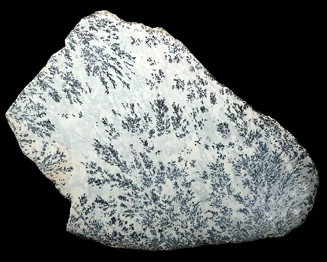


Yellowstone Mine, Gravelly Range, Madison County, Montana, USA