| Locality type: | Road Cutting |
| Classification |
|---|
|
| Species: | Greenockite |
| Formula: | CdS |
| Formation: | Secondary |
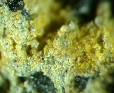
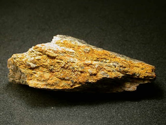
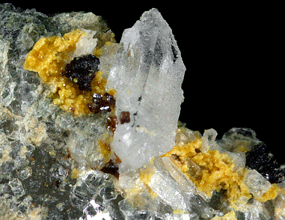
| Comments: | yellow encrustations in the veins with galena, quartz, sphalerite, fluorite commonly labeled greenockite are not confirmed. SEM-EDS on one came back as “Probably a mixture of Fe, Mn, and Zn oxides/hydroxides and/or carbonates. Maybe goethite, hydrozincite, and a Mn mineral(s)? Definitely not greenockite or and any other sulfide. We checked another spot and got similar results, except no Mn.” Perhaps impure smithsonite. |
| Habit: | crusts and films on schist, free standing micro crystals on quartz and sphalerite |
| Colour: | yellow |
| Quality for species: | Poor for species, only of interest for locality collectors. (#) |
| Abundance at site: | Rare |
| Confirmation |
|---|
|
| Validity: | Unconfirmed/Questioned |
| Data |
|---|
|
| Mineral Data: | Click here to view Greenockite data |
| Locality Data: | Click here to view State Route 25 road cuts, Trumbull, Fairfield County, Connecticut, USA |
| Photo Gallery | View Gallery (3 photos) |
| Data Identifiers |
|---|
|
| Mindat Occurrence Record ID: | 414788 |
| Long-form Identifier: | 1:3:414788:6 |
| GUID (UUID V4): | fa4483f1-f9a7-4f66-adc5-163afb54fc87 |
| Nearest other occurrences of Greenockite |
|---|
|
|
| 19.4km (12.0 miles) | ⓘFillow Quarry (Branchville Quarry; Branchville Mica Mine; Smith Mine), Branchville, Redding (Reading), Fairfield County, Connecticut, USA |
| 26.4km (16.4 miles) | ⓘU. S. Route 7 Expressway (Danbury line to Iron Works District), Brookfield, Fairfield County, Connecticut, USA |
| 28.4km (17.6 miles) | ⓘOld lead mine, Brookfield, Fairfield County, Connecticut, USA |
| 36.2km (22.5 miles) | ⓘRoxbury Iron Mine (Shepaug Iron Company Mine; Shepaug Spathic Iron and Steel Company Mine), Mine Hill (Ore Hill), Roxbury, Litchfield County, Connecticut, USA |
| 50.1km (31.1 miles) | ⓘThomaston Dam railroad cut, Thomaston Dam, Thomaston, Litchfield County, Connecticut, USA |
| 59.8km (37.2 miles) | ⓘMiddletown lead mines (Middletown Mine), Middletown, Middlesex County, Connecticut, USA |
| 62.9km (39.1 miles) | ⓘHaverstraw, Rockland County, New York, USA |
| 63.3km (39.3 miles) | ⓘStrickland Quarry, Strickland pegmatite, Collins Hill, Portland, Middlesex County, Connecticut, USA |
| 85.9km (53.4 miles) | ⓘCanaan, North Canaan, Litchfield County, Connecticut, USA |
| 88.5km (55.0 miles) | ⓘProspect Park Quarry, Prospect Park, Passaic County, New Jersey, USA |
| References |
|---|
|
|


State Route 25 road cuts, Trumbull, Fairfield County, Connecticut, USA