 | | Journal (article/letter/editorial) | | the --------Arkansas Magnet Cove locality. - - - - - - - - Minerals of the Wilson Springs Vanadium Mines...Mines POTASH SULPHUR SPRINGS, ARKANSAS J. MICHAEL HOWARD Arkansas Geological Commission 3815 West Roosevelt...Little Rock, Arkansas 72204 DON R. OWENS Earth Science Department University of Arkansas at Little Rock...Rock 2801 South University Little Rock, Arkansas 72204 Unless otherwise noted, all photos by J. Michael...Owens collection 154 ROCKS & MINERALS Sulphur Springs was taken by William H. Lewis in 1844. By 1855 |  | | Report (issue) | | IGNEOUS ROCKS AND CARBONATITES, POTASH SULPHUR SPRINGS IGNEOUS COMPLEX, ARKANSAS by Marta J.K. Flohr1 and...Geological Survey editorial standards (or with the North American Stratigraphic Code). Any use of trade,...Geology Center 3815 West Roosevelt Road Little Rock, Arkansas 72204 1995 CONTENTS PAGE Introduction ......Generalized geologic map of the Potash Sulphur Springs Igneous Complex, Arkansas ............................of M162 drill core samples, Potash Sulphur Springs Igneous Complex, Arkansas ......................... |  | | Journal (article/letter/editorial) | | maps on Google seemed to average twelve states (North Dakota, South Dakota, Nebraska, Kansas, Minnesota...states at its 2017 February show (add Oklahoma, Arkansas, Kentucky, and Tennessee); hence, they will all...states— Michigan, Wisconsin, South Dakota, and Arkansas—at the periphery of the area tally over three...completely overlap. It is clear that their source springs from many more rock types than just sedimentary...phosphate species being described from just one mine, the Tip Top, in South Dakota. (Note: There are |  | | Book | | Collecting Arkansas JVlinerals A Reference and Guide By Arthur E. Smith, Jr. ,'T Collecting Arkansas...Box 2043 Coeur d’Alene, Idaho 83816-2043 iii Arkansas Counties 1 \ I •( 11 o •« c »««ou cxi ju4«iO«J...573-308-3500 703-648-6045 or phone 800-USA-MAPS Map 3. Arkansas’ Ouachita Mountains 7.5 Minute Quadrangal...Quadrangal Map index. V Contents and Locality Index Arkansas Quartz Crystal Deposits Special Quartz Types....Location 1 Montgomery County quartz deposits................. Other Montgomery County quartz mines...... |  | | Journal (issue) | | werner@lcturbonet.com In the Green River Basir of Sweetwater County, Wyoming, lies the world's largest,known deposit...supplied by volcanic ash ·and andesitic tuff from the north and was leached from the detrit:l!l.m~terii,iltranspo~~d-foto·the...say it is only known from 3 ·i are~: Garland County in Arkansas, Cornwall in the United Kingdom, and·the...visiting the North Wilson pit, a vanadium mine near Wilson· Springs (also type locality for miserite and straczekite;...straczekite; in Garland County, Arkansas). Buford Nichols had brought along his field stereomicroscope |  | | Report (issue) | | A note on newly discovered kimberlites in Riley County, Kansas William L. Mansker, Bill D. Richards, and...petrography of the Twin Knobs ttl lamproite, Pike County, Arkansas . 205 Michael A. Waldman, Tom E. McCandless...McCandless, and Hugo T. Dummett The Cretaceous Arkansas alkalic province; A summary of petrology and geochemistry...crystals from the Potash Sulfur Springs igneous complex, Garland County, Arkansas Robert E. Zartman and...Michael Howard . 235 Isotopic relationships in Arkansas Cretaceous alkalic complexes . 241 G. R. Tilton |  | | Book (volume) | | Lavrion, Greece (6) and Cu-poor adamite from Ojuela mine, Mexico (7) IR spectra of acid salts (silicates...abbreviations are used in this chapter: Mt. mountain Co. county IR infrared D density Dmeas measured density Dcalc...CaB3O4(OH)3·H2O Locality: Boron Open Pit, Boron, Kern Co., California, USA. Description: Colourless crystal...Mn2+BO2(OH) Locality: Franklin, Sussex Co., New Jersey, USA (type locality). Description: Pink massive aggregate...Arsenato-Borates Sussexite 29 Mn2+BO2(OH) Locality: Gonzen mine, Sargans, St. Gallen, Switzerland. Description: |
|
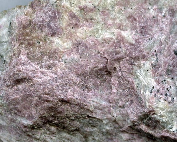


North Wilson pit, Union Carbide Mine, Wilson Springs, Garland County, Arkansas, USA