 | | Report (volume) |
| ______________--___-__-_.--------------------- Pomeroy quartz monzonite of Crawford.___-_-_---_-_---.---- ...._______________________________------______---Beryllium-bearing quartz veins of other areas-_____-___-_---_-_-___--Index...COLORADO By JOHN W. ADAMS ABSTRACT Pegmatite and quartz veins that contain beryllium minerals occur in...stock. A beryl-bearing quartz vein, once mined for molybdenite, occurs in quartz monzonite at the California...California mine southwest of Mount Antero. Mineralogical study shows that some of the beryl was formed during |
 | | Journal (article/letter/editorial) |
| Canadian Shield. The bedrock of the surrounding district is meta-sedimentary and igneous. The dike is a...INTRODUCTION The Leduc Pegmatite is situated on the southwest face of a ridge just over one mile south of Lac...Wakefield running northwest along the shore of the southwest arm of Wakefield Lake for approximately four miles...small clearing (% mi.) one finds a trail leading southwest to a stream. From the opposite side of the stream...direction, ending at the quarry face. The region of the Gatineau-Lièvre District in which the Leduc Pegmatite |
 | | Journal (article/letter/editorial) |
| for each precisely defined lacality or center of an area are included in parentheses. A few of the most...and minute balls of GOETHITE. earthy hematite, quartz (Broadhead 1873b, 1877). Audrain County Mexico...Columbia, in quartz-chalcedony geodes: DICKITE. In Pennsylvanian-age fossil wood: quartz as colorless...Boone County Adrlan’s quarry (38-40-23N 092-13-54W), an agricultural and road limestone quarry between Ashland...(limonite), QUARTZ. Callaway County Knight bank (38-45-13N 093-03-44W). an iron mine 5 miles southwest of Fulton |
 | | Journal (issue) |
| GALENA CRYSTALS, BARITE CRYSTALS, CALCITE CRYSTALS, QUARTZ CRYSTALS ETC. EACH PIECE TRIMMED AND SELECTED FOR.............................. .............. 485 AN UNUSUAL OCCURRENCE—Gardiner E. Gregory ............STORY—Ted Schoen .............. ..................... 518 AN EXCITING MONTH—Wayne D. Pennington.................on geologic hazards in California. Dr. Allen heads an 11-man group to advise on the state’s proper program...Auditorium, Topeka. Kans. 66616. Oct. 2, 5, 1965 — Miami Valley Mineral and Gem Club Annual Show at the Dayton |
 | | Journal (issue) |
| already. The occasional faceted stone will show up in an illustration here and there, but we are still the...localities: the Himalaya dike system, Mesa Grande district, California (by E. E. Foord) [1977, vol. 8, no...three-dimensional model of a tourmaline crystal, an impossible tourmaline crystal that is, zoned with...with a dif ferent tourmaline color on each face! A Special Thanks to our Anonymous Donor from Georgia...702-883-2598 Affiliated with the Friends of Mineralogy, an independent, non-profit organization devoted to furthering |
 | | Journal (issue) |
| Museum Toronto, Ontario Steven R. Morehead Green Valley, AZ Donald R. Peacor University of Michigan Ann...lived in the area all his life. He left school at an early age and started work on the family farm, but...something had irked him he’d pay me a visit just to start an argument and let off some steam. I gradually lost...California and eventually served as its President. He was an enthusiastic field collector and a gregarious and...what was previously known as the Saint-Michel district, and is now part of the Arrondissement de Vil |
 | | Report (issue) |
| of Connecticut ___ _ Geology of the Middletown district ___________ _ Rock units ____________________________...Haven County ________________________ _ Southford quartz-feldspar quarry_-------Bibliography __________...44. 45. 46. 47. 48. Index map of the Grafton district., New Hampshire, showing locations of mines and...and prospects. Index map of the Keene district, New Hampshire, showing locations of mines and prospects..._ -Generalized geologic map of the Middletown district, Conn __________ ·-------------------------------------Types |
 | | Report (volume) |
| veins Origin of the shoots Milling High Grade district, Modoc County, Cal Location History of mining...replacements in glassy rhyolite Future of the district Winters district, Modoc County, Cal Location and accessibility...rocks 2 56 Intrusive rocks 2 57 Dike rocks in the quartz monzonite 2 2 57 Contact metamorphism Extrusive...Quaternary. deposits 2 59 2 Ore deposits 59 Quartz veins in quartz monzonite 2 59 General features 2 60 2...64 Future of the districts 64 Battle Mountain district, Lander County, Nev 2 Location and accessibility |
 | | Report (volume) |
| mine, Cheshire County, N. H.; B, Mica crystals in a face of pegmatite in the. deep stope under open cut shown...A, Contact of pegmatite and gneiss in northeast face of open cut at Firestone mica mine, near Custer...9. Outcrop of irregular streak of mica between quartz and feldspar in S. A. Grady's claim, Mesa County..._ 12831. Plan of Palermo mica mine, 1$ miles southwest of North Groton, N. H., showing geology___ __... Sketch of Texas Mica Co.'s claims, 15 miles southwest of Van Horn, Culberson County, Tex., showing topography |
 | | Report (issue) |
| GEM- AND LITHIUM-BEARING PEGMATITES OF THE PALA DISTRICT, SAN DIEGO COUNTY, CALIFORNIA By RICHARD H.... GEM- AND LITHIUM-BEARING PEGMATITES OF THE PALA DISTRICT, SAN DIEGO COUNTY, CALIFORNIA! By Richard H....Feldspars Gem minerals Tourmaline Spodumene Bervl Quartz Other minerals MINING Prospecting and mining methods...parts of the Pala district and In pocket Map of northern part of the Pala district, showing distribution...Aerial view of the Pala district 3. Aerial view of northern part of Pala district 17 4. Aerial view |
 | | Report (volume) |
| features and mineral resources of an area in the Missouri River valley where a power dam is being built...River :flows northwest across the quadrangle, and an old dam at Canyon Ferry impounds a lake 6 miles long...the river from the northeast, and one from the southwest, are perennial; all the others are intermittent...though not a principal watershed, bound the valley on its southwest side. Prominent river-cut terraces at several...Helena limestone, all belonging to the Belt series. An unknown thickness of overlying Belt rocks has been |
 | | Report (issue) |
| metavolcanic rocks Hybrid gneisses and associated quartz diorite and granodiorite (Cretaceous and/or older)...(Cretaceous) , Gabbroic rocks Granitic rocks Green Valley _. tonalite Lakeview Mountain tonalite Lake...88 88 88 89 89 district Mesa Grande district __ Ramona district Rincon _ district Other areas Miscellaneous...96 96 97 97 115 116 . _ Gold District summaries Julian district Escondido region Mesa Grande ... Dulzura 121 121 district (Rice) district Ballena placer deposits Additional gold mines Boulder Creek |
 | | Book |
| my father worked. During the winter of 1943 -1944 an air raid hit our house with several incendiary bombs...moved up to Bolton in Lancashire. My father being an aircraft fitter/engineer was relocated to work in...refurbish petrol stations. One of our contracts was an extension to a ladies' hairdressers shop in Downend...small plastering company and I spent four years as an apprentice with him. We also carried out general...China Clay Group Ltd. This later enabled me to obtain an annual pass into the working clay pits. The company |
 | | Report (issue) |
| OF THE INTERIOR GEOLOGY OF THE HANOVER-YORK DISTRICT PENNSYLVANIA GEOLOGICAL SURVEY PROFESSIONAL PAPER...of recumbent fold in albite-chlorite-muscovite-quartz schist, 7 miles northwest of Tucquan anticline;...anticline; B, Fold in albite-chlorite-muscovite-quartz schist; C, Muscovite-chlorite-quartzs chist, from Muddy...Chloritoid-muscovite-quartz schist, from Saubel Hill; B, Chloritoid-muscovite-quartz schist, from Hoffacker Valley; C,... Banded chlorite-muscovite-quartz schist, half a mile south of Freysville________________________ 15 |
 | | Journal (volume) |
| Geologist C. A. Logan, District Mining Engineer C. McK. Laizure, District W. Burling Tucker, Reid...J. C. District Mining Engineer District Mining Engineer Mining Engineer O'Brien, District Mining...Mining Engineer George John District Sampson, Assistant Chas. V. Averill, Mining Engineer L. Gary,...Mines, by Walter W. Bradley SAN FRANCISCO FIELD DISTRICT Mines and mineral resources of 7 11 Santa...San Francisco Field District, by C. McK. Laizure 53 LOS ANGELES FIELD DISTRICT 58 Current notes on |
 | | Report (issue) |
| youngest, Flood, Taft Hill, Vaughn, and Bootlegger. Quartz sandstone and very dark gray shale characterize...sandstone, a medial slope-forming dark-gray shale, and an upper thick cliffforming sandstone that contains...thick glauconitic sandstone separating a lower and an upper unit of silty bentonitic shale and thin glauconitic...unit of pale-yellow friable arkosic sandstone and an upper unit of bentonitic clay and tuffaceous siltstone...common in the upper sandy unit. Neogastroplites, an ammonite believed to be of latest Albian and earliest |
 | | Report (issue) |
| _ . ---------_----_-__---------___-_---_--.-_-.Quartz diorite__ ___---_-----___-__.---_-------------_-...Creek district._______-_----__-__-_ 12. A, Chalcopyrite-molybdenite stringer in normal quartz diorite;...diorite; B, Rhombic blocks produced by jointing in quartz diorite; C, Lucky Shot mine and camp and War Baby..._________ 26. Contact of dacite dike rock with quartz dioiite country rock in Lucky Shot mine--_____...pegmatite dike on Holland property, on eastern valley wall of upper Purches Creek_____________________ |
 | | Report (issue) |
| properties based partly or entirely on earlier reports. An introductory section on production, consumption,........... .. Pegmatitic quartz veins .... .. ......... ... ....... ... Quartz veins ... ... .. .........and stock-work deposits ..... .. ... .. .. . Gold-quartz veins ..... .. ....... .. .. .... .. .. Veins of......... .... ..... .... .... .... ... . Kenora district (Patricia portion) .... ... .... . Red Lake area... .. .. .. .... .. .... .. ...... ... . Kenora district...................... .... .. ............. . |
 | | Report (issue) |
| lisl, w hich included some 180 mineral species and an additional 95 varieties, was said to embrace "all...certainty, as occurring in Canada". In addition lo being an authoritative index as to the knowledge of Canadian...to record all reported localities of occurrence. An arbitrary list of common minerals was drawn up and...103P/12 - 4- Argentite occurs in bluish black vuggy quartz associated with pyrite, ga l ena, sphalerite ,...River , Skeena mining division (R. M. Thompson, 1953: Am. Mineralogist, 38, p . 545 ). Northwest Territories |
 | | Book |
| Cover illustration: Photo by Megh Raj Dhital South face of Mt Nilgiri, viewed from Tatopani. Printed on...and Southeast Himalaya and the Peninsular India. An elaboration of this aspect forms a basis for regional...unique to the Nepal Himalaya; their genesis makes an interesting reading. Neotectonics having environmental...conclusions, but the narrative is exhaustive and makes an absorbing reading. He has succeeded in his task and...deeper insight into the subject matter may bring out an order out of the chaos. These theoretical discourses |
 | | Book (edition) |
| Bureau 71a, 187; Utah Travel Council 74; Tennessee Valley Authority 76, 118; Robert Wenkam 81; State of New...STATES 98 THE SOUTH 106 THE MIDWEST 132 THE SOUTHWEST 158 THE ROCKIES 167 THE PACIFIC COAST 181...SOUTH 83 STATES 109 THE MIDWEST 135 THE SOUTHWEST 161 THE ROCKIES 171 THESPAGIFIC ‘COAST —183...outdoor vacations may be, all have one thing in common: an outdoor vacation relates a human being to his living...In this time of environmental and energy crisis, an outdoor vacation takes on new significance. Each |
 | | Report (volume) |
| was published in 1902. This bulletin contains: (1) an alphabetical listing of 1,500 North American sedimentary...periods to which they had been assigned, and (3) an index list of formation names. The next con1pilation...826, by M. Grace Wilmarth. This work was actually an extract from a larger, more exhaustuve compilation...that were published before 1956 are arranged to form an index to both the Wilmarth Lexicon (1938) and the...n1oraines and other units of which physiography is an essential part of the definition, and (4) names of |
 | | Book |
| llIS _ARGUS _. _ARD_ EXCRLLEXCY, oovEn_on, Am) e:c o_lcio pR_n)_'r • p[I1ST CONGnES_IDNAI, DI_TIRICT... authorlzcd in 1536, .:+and a ]_inal Report is an octavo volume of 301 pages. ations, and gives our...][. Cook, Assistant and Henry vey was continued an(1 was carried Chemist Geologist; Tope- T. 1_...tlairty-six per cent. :From 1850 to 1860 there was an increase of thirtyseven and one-tburth per cent....cbangcd the faccs of the ficlds_ aad brought _brward an improved and thrifty agriculture. New Jcrsc)5 though |
 | | Report (issue) |
| of the Potosi volcanic series as seen down the valley of the Rio Grande from north of Weminuche meadows...lower talus-covered slopes are underlain by Huerto quartz latite and Alboroto rhyolite. Geology and Petrology...study of the occurrence and origin of the rocks in an area of I2fiOO square miles in southwestern Colorado...Cross in 1895. The project was originally planned as an areal survey on folio scale (1:62,500) for presentation...___________________ Biotite schist..._______-.___-__-_--_ Quartz-inuscovite schist- ____________ Amphibole schist |
 | | Book |
| Down: Earthquakes and Rock Avalanches in Yosemite valley 8. How Water Sculpts Yosemite: The Flood of 1997...1997 111 9. A Natural Dam Across Yosemite Valley: The El Capitan Moraine 121 10. Cracks in the Earth:...Sentinel Dome and Half Dome 139 12. The Earth as an Onion: Exfoliation Joints 147 13. The Ice Went...Rocks: Metamorphic Rocks at May Lake 187 18. Root of an Ancient Volcano: Little Devils Postpile 195 19...Nevada 225 22. An Ancient, Ice-Bound Sea: Mono Lake and Ancestral Lake Russell 235 23. An Underwater Volcano: |

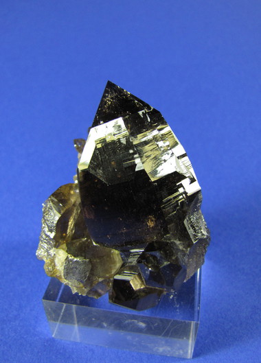

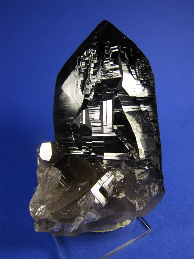


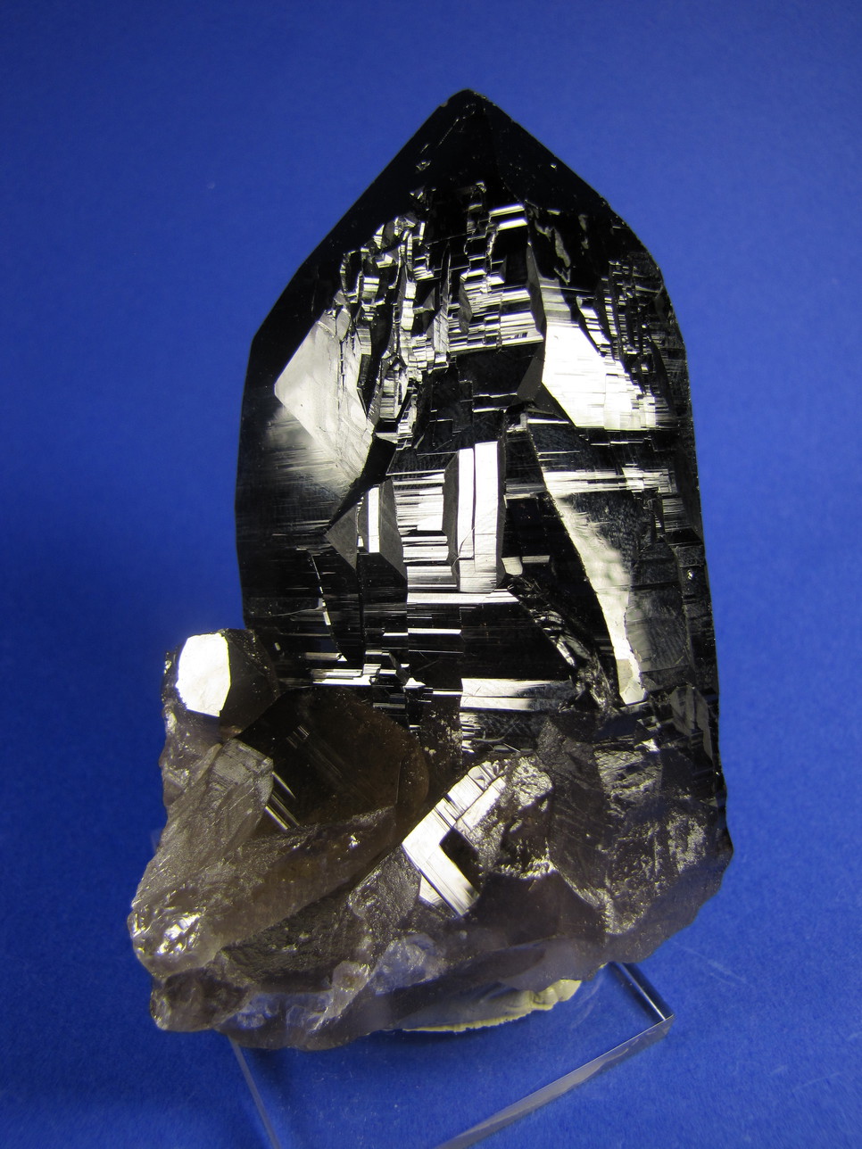


Southwest face, Hocharn, Große Fleiß valley, Heiligenblut am Großglockner, Spittal an der Drau District, Carinthia, Austria