| Locality type: | Mine |
| Classification |
|---|
|
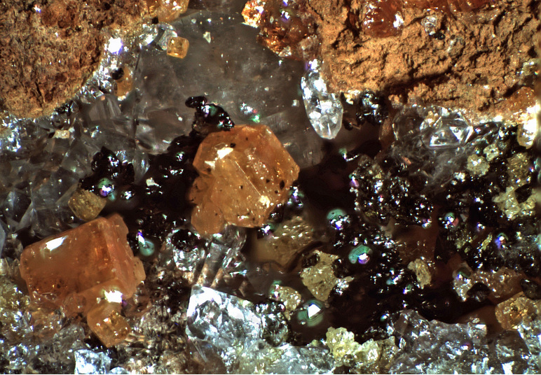
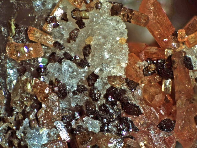
| Species: | Descloizite |
| Formula: | PbZn(VO4)(OH) |
| Confirmation |
|---|
|
| Validity: | Confirmed |
| Confirmation Methods: | Visually Identified |
| Associated Minerals Based on Photo Data: |
|---|
|
| Vanadinite | ⓘ3 photos of Descloizite associated with Vanadinite at this locality. |
| Quartz | ⓘ2 photos of Descloizite associated with Quartz at this locality. |
| Rock Crystal | ⓘ1 photo of Descloizite associated with Rock Crystal at this locality. |
| Data |
|---|
|
| Mineral Data: | Click here to view Descloizite data |
| Locality Data: | Click here to view Robert E. Lee Mine (Bob Lee Mine; Bob Lee and Widow Mine), Tres de Mayo Mine group, Palmetto District, Fresno Canyon, Patagonia Mountains, Santa Cruz County, Arizona, USA |
| Photo Gallery | View Gallery (3 photos) |
| Data Identifiers |
|---|
|
| Mindat Occurrence Record ID: | 1223520 |
| Long-form Identifier: | 1:3:1223520:1 |
| GUID (UUID V4): | c928c789-d3c2-48d2-bb2e-d8a2a409a338 |
| Nearest other occurrences of Descloizite |
|---|
|
|
| 8.4km (5.2 miles) | ⓘSalvador Mine (Salvadore Mine; San Salvador Mine), Hermosa group, Hardshell Gulch, Harshaw, Harshaw Mining District, Patagonia Mountains, Santa Cruz County, Arizona, USA |
| 8.4km (5.2 miles) | ⓘHardshell Mine (Manto Mine; Eagle-Picher properties), Hardshell Gulch, Harshaw, Harshaw Mining District, Patagonia Mountains, Santa Cruz County, Arizona, USA |
| 13.5km (8.4 miles) | ⓘJ.C. Holmes Mine (J.C. Holmes claims), Temporal Gulch, Wrightson Mining District, Santa Cruz County, Arizona, USA |
| 27.0km (16.8 miles) | ⓘGlove Mine (Sunrise Mine), Glove Mine group (Zombie & Zeco claims; Festiago-Franklin; Blacksmith adit), Cottonwood Canyon, Tyndall Mining District, Santa Cruz County, Arizona, USA |
| 27.0km (16.8 miles) | ⓘGlove Mine group (Zombie & Zeco claims; Festiago-Franklin; Blacksmith adit), Cottonwood Canyon, Tyndall Mining District, Santa Cruz County, Arizona, USA |
| 53.4km (33.2 miles) | ⓘTotal Wreck Mine, Cienega Creek, The Narrows, Empire Mining District, Empire Mountains, Pima County, Arizona, USA |
| 54.0km (33.6 miles) | ⓘTwin Buttes Mine, Twin Buttes, Pima Mining District (Olive Mining District; Mineral Hill Mining District; Twin Buttes Mining District), Sierrita Mountains, Pima County, Arizona, USA |
| 64.5km (40.1 miles) | ⓘManila Mine, Tombstone Mining District, Cochise County, Arizona, USA |
| 65.7km (40.8 miles) | ⓘGallagher Vanadium & Rare Minerals Corp Mine, Tombstone Mining District, Cochise County, Arizona, USA |
| 68.8km (42.7 miles) | ⓘSuperior Mine, Tombstone Mining District, Cochise County, Arizona, USA |
| References |
|---|
|
|


Robert E. Lee Mine, Tres de Mayo Mine group, Palmetto District, Fresno Canyon, Patagonia Mountains, Santa Cruz County, Arizona, USA