 | | Journal (article/letter/editorial) | | leaf gold, smoky quark, and turquoise specimens, New Mexico boasts an array of mineral species. RAMON S....Albuquerque, New Mexico 87110 THE PURPOSE OF THIS INDEX is to provide a comprehensive listing of New Mexico...Particular attention was directed toward incorporating new information on discoveries and occurrences, although...to compile all of the mineral occurrences in New Mexico-a venture of that magnitude is beyond the scope...Minerals of New Mexico is the basic reference for locations. Abstracts from the New Mexico mineral symposia |  | | Report (issue) | | = 114.50(2)◦ X-ray Powder Pattern: Squaw Creek, New Mexico, USA. 3.290 (100), 2.614 (80), 3.039 (75)...09 8.02 3.38 Total 99.8 100.00 (1) Squaw Creek, New Mexico, USA; by electron microprobe, average of... hematite, quartz, tridymite, pseudobrookite, sanidine, chernovite-(Y), gasparite-(Ce), tilasite, heulandite...From the Squaw Creek tin prospect, Catron Co., and in Willow Spring Draw, Sierra Co., Taylor Creek district...district, New Mexico, USA. Name: Honors Charles Henry Maxwell (1923– ), geologist with the U.S. Geological |  | | Journal (article/letter/editorial) | | Figure 1: Charles Henry Maxwell (1989); R. B. Taylor, USGS, photo. 332 ROCKS & MINERALS MAXWELLITE...fluoro-arsenate, was found at the Squaw Creek tin prospect, Catron County, and at another tin deposit at...at Willow Spring Draw, Sierra County, New Mexico. The mineral is monoclinic with space group Aa or A2/a...mineraIs are squawcreekite, quartz, tridymite, sanidine, pseudobrookite, hematite, Fe- and Sb-bearing...not have his Ph.D. degree (M.S. from Univ. of New Mexico) but he knows more than 10 normal Ph.D.’s put |  | | Journal (article/letter/editorial) | | several localities in the Black Range, southwestern New Mexico. Individual nuggets, 3 cm or less in diameter...depositedoriginally as fracture fillings in the Tertiary Taylor Creek rhyolite with which it is closely associated...alluvial gravels in the Black Range tin district of southwesternNew Mexico. Rarely, it is observed in situ as...as fracture fillings in the Taylor Creek rhyolite of Tertiary age (Fig. l) that forms flow-domes exposedjust...exposedjust west of the Continental Divide in Sierra and Catron Counties(Fries, 1940;Fries and Butler, 1943;Lufkin |  | | Journal (article/letter/editorial) | | Thirty-seventh list of new mineral names. Part 2: M-Z A. M. CLARK Department of Mineralogy, The Natural...Africa vanadium deposit, Wilson Springs, Garland County, Arkansas, U.S.A. FeZr(PO4)2-4H20. Monoclinic,...complexes, Questa, Tats County, grains and aggregates, up to 5 mm across and New Mexico, U.S.A. Amphibole Group...1991. Neues Jahrb. complex, Questa, Tats County, New Mexico, Min., Mh., 169. As bladed, coloudess to...237 names, of which 222 are new species, approved by the IMA Commission on New Minerals and Mineral Names |  | | Journal (article/letter/editorial) | | related to the eruptives of the northern hills, the district will not be included in this paper. For a description...uplift. 11. TOPOGRAPHY. The topography of the district is intimately connected with the,general gcological...largest and most important stream being Spearfish creek. This stream, follows a winding course with a general...precipitous caiions in the hills. It crosses the district in the shape of a bow, in the southern arm of...valley which surrounds the hills. Into Spearfish creek, from the west flow Iron and Little Spearfish and |  | | Report (volume) | | Range Primitive Area Greenlee County, Arizona, and Catron County, New Mexico By JAMES C. RATTE, E. R. LANDIS...Range primitive area, Greenlee County, Arizona and Catron County, New Mexico. The area discussed in the report...location of Blue Range primitive area, Arizona and New Mexico. _________________________ E3 2. Index map showing...andesite unit, about 1 mile below mouth of Stray horse Creek. __________ 11. Gila Conglomerate filling channel...RANGE PRIMITIVE AREA, GREENLEE COUNTY, ARIZONA AND CATRON COUNTY, NEW MEXICO By JAMES C. RATTE, E. R. LANDIS |  | | Journal (article/letter/editorial) | | significanceof a carbonat_e-ric_h lamprophyrefrom squaw creek, northern Black Hills, SouthDakola Jaues G. KncsNER...soda-minetterock occursintermixed with a leuco-phase along Squaw Creek in the northern Black Hills. It consistsof phenocrystsof...syeniteporphyry, and pseudoleuciteporphyry in the Tinton mining district. Welch (1974\ has done further work on this...soda-minette(Fig. l) on the northeast bank of Squaw Creek, about 50 metersnorth of the sectionline separatingsections16...trachyteporphyry and phonolite porphyry intrusions along Squaw Creek, and also is probably genetically related to |  | | Report (issue) | | ........................................ Apple Creek Formation................................................................................ Lawson Creek Formation.................................................. Carbonate rocks in the Bayhorse mining district................................................... Basal dolomite of Bayhorse Creek....................................................................................... Upper carbonate of Cash Creek................................................ |  | | Report (issue) | | Sunnyside Mine-Marble Creek area............................ 2 Yellowjacket Creek-Camas Creek-Panther CreekMorgan...CreekMorgan Creek area........................................... 5 Intrusive rocks of uncertain age...age............................ 10 Corral Creek-Iron Creek area................................ 11 Twin...Twin Peaks caldera-East Fork Mayfield Creek area............ 12 Challis-Custer Graben-East Fork-Jerry Peak...of Steiger and Jaeger (1977).] SUNNYSIDE MINE-MARBLE CREEK AREA Tl Tqp Tir Tds Tmi Tsu Tmx Tslu |  | | Journal (article/letter/editorial) | | potassium-argon determinations on biotite and sanidine from ash flow sheets in eastern and northern Yellowstone...determination on biotite from a dacitic stock on Big Creek in the south-central Fridley Peak quadrangle yields... and biotite from a dacite stock in lower Mill Creek Canyon north of Emigrant Peak yielded 49.0 + 1.7...belt includes (4) Sunlight Basin and Sunlight mining district (Parsons, 1939,1958,1968), (5) Crandallor Hurricane...1962), (6) Cooke City mining district (Lovering, 1929), (7) Independence mining district (Emmons, 1908; Rubel |  | | Report (issue) | | the along the south rim of Clover Creek at the convergence of Deer Creek, to over 80m thick adjacent to...to the landslide on Clover Creek in Section 29, T.3S R.13E. Typical outcrops are 8m thick. The unit forms...The flows can be traced along the rim of Clover Creek south for 10km and into Smiths map area 15km to...terminates to the north in the vicinity of the Pole Creek fault zone. The unit lies in angular unconformable...the tuff of City of Rocks, diatomite of Clover Creek and tuff of Gwin Springs. The basalt is dips 2° |  | Ratte, James Clifford, Gaskill, D.L., Eaton, G.P., Peterson, D.L., Stotelmeyer, R.B., Meeves, H.C. (1972) Mineral resources of the Gila Primitive area and Gila Wilderness, Catron and Grant Counties, New Mexico. Open-File Report Vol. 1972 (72-306) US Geological Survey doi:10.3133/ofr72306 | Report (issue) | | PRIMITIVE AREA AND GILA WILDERNESS, CATRON AND GRANT COUNTIES, NEW MEXICO By James c. Ratte, Gordon P. Eaton...the Gila Primitive Area and Gila Wilderness, New Mexico; as defined, and some bordering areas that may...Wilderness looking northeast from Leopold Vista, Catron County, N.Mex. (1) Nabours Mountain, (2) Wilcox Peak...Sheridan Gulch, (5) Sheridan Mountain, (6) Big Dry Creek, (7) Black Mountain, (8) Crown Mountain, (9) West...West Baldy, (10) Sacaton Mountain, (11) Little Dry Creek, (12) Haystack Mountain. IN REPLY REFER TO: UNITED |  | | Report (issue) | | Chaffee County, Colorado GEOLOGICAL SURVEY Work done in cooperation with the Colorado State Mining Industrial...Deposits of the Poncha Springs SE Quadrangle, Chaffee County, Colorado By RALPH E. VAN ALSTINE GEOLOGICAL ...Work done in cooperation with the Colorado State Mining Industrial Development Board Description of PreCambrian...quadrangle, Chaffee County Gravel pits in the Poncha Springs SE quadrangle, Chaffee County in GEOLOGY AND...DEPOSITS OF THE PONCHA SPRINGS SE QUADRANGLE, CHAFFEE COUNTY, COLORADO By RALPH E. VAN ALSTINE ABSTRACT The |  | | Report (volume) | | 8 n 51 Z' O w d< w w Z w w X 8 JK RANGE, NEW MEXICO GEOLOGICAL SURVEY BULLETIN 1319-E Mineral...Primitive Area, Grant, Sierra, and , Catron Counties, New Mexico By GEORGE E. ERICKSEN, HELMUTH WEDOW...the Black Range Primitive Area and vicinity, New Mexico. The area discussed in this report includes the...rhyolite of Rocky Canyon and rhyolite of Diamond Creek ............................................................................................. 49 Mining claims in the primitive area ................. |  | | Report (volume) | | H. MclNTYRE Papers presented at the Northwest Mining Association Convention, Spokane, Washington, Dec...bulletin ; 1658A-S) "Papers presented at the Northwest Mining Association Convention, Spokane, Washington, Dec...Congresses. I. Mclntyre, David H. II. Northwest Mining Association (U.S.). Convention (1983 : Spokane...Volcanic Subsidence in the Custer Graben, Custer County, Idaho, by D. H. Mclntyre and K. M. Johnson. 109...Douglas-Fir at the Red Mountain Stockwork, Yellow Pine District, Idaho, by J. A. Erdman, B. F. Leonard, and D |  | Theodore, T. G., Kotlyar, B. B., Singer, D. A., Berger, V. I., Abbott, E. W., Foster, A. L. (2003) Applied Geochemistry, Geology, and Mineralogy of the Northernmost Carlin Trend, Nevada. Economic Geology, 98 (2) 287-316 doi:10.2113/gsecongeo.98.2.287 | Journal (article/letter/editorial) | | rocks from two 71⁄2-minute quadrangles, as well as new chemical analyses of approximately 1,000 drill core...in a 1,514 m (4,970 ft) hole through the Rodeo Creek deposit were used to construct three-dimensional...zonation in the mineralized systems. The Rodeo Creek deposit comprises deep Ag base-metal ± Au-mineralized...rather than distal halos related to either the Rodeo Creek or the nearby Dee and Storm gold deposits. Application...interpretations of geochemical halos in the Carlin trend. District-scale geochemical patterns of several elements |  | | Report (volume) | | Geology of the Rockland and Arbon Quadrangles, Power County, Idaho By DONALD E. TRIMBLE and WILFRED J. CARR............................................ Worm Creek Quartzite Member . . . . . . . . . . . . . . . .................................... · · · · Deep Creek Formation ........................... · · · · ·.... . . . . . . . . . . . . . . . . . . . Little Creek Formation . . . . . . . . . . . . . . . . . . ..... . . . . . . . . . . . . . . . . . . . Little Creek Formation . . . . . . . . . . . . . . . . . . . |  | | Report (volume) | | AND ORE DEPOSITS OF THE BAYHORSE REGION CUSTER COUNTY, IDAHO BY CLYDE P. ROSS Prepared in cooperation...rocks__-___-____________---_-_-___-_-_-________ Garden Creek phyllite.....__--_-___---__-__--_--_-______-Bayhorse...rocks_______________________________________________ Trail Creek formation...__________________________________ Laketown...mines_________ Bayhorse district..______.__________--__--__-__-_--_-_.._ Good Hope mine.___________________________________...______ Deposits near Garden Creek._________-_-_-_____-.-__ Ramshorn mine._____.___-_______-___-.-_-__--_---__ |  | | Report (issue) | | Mear the Oentral Part of the Lemhl Range, Lemhi County, Itlaho tJ.S, GEOLOGICAL SURVEY PROFESSIONAL PAPER...Near the Central Part of the Lemhi Range, Lemhi County, Idaho By EDWARD T. RUPPEL and DAVID A. LOPEZ ...near the central part of the Lemhi Range, Lemhi County, Idaho. (U.S. Geological Survey professional paper...Inyo Creek Formation ..................... West Fork Formation ..................... Big Creek Formation...Formation ...................... Apple Creek Formation .................... Gunsight Formation .......... |  | | Journal (article/letter/editorial) | | ........................................ Stone Creek pegmatite................................................. Horse Creek quartz-dioritepegmatites............................. Mica Creek peridotitepegmatite............................................ Gird Creek pegmatites........................................the BearpawMountainswhichhe hasstudiedin detail. Mine and prospectownersinvariablygavegenerouslyof their...examples from the Drurfilommon mine. Occurrencesnear Haystack Stock, Park County,were mentionedby Emmons(5) |  | | Report (issue) | | and gold deposition in the Betze deposit, Eureka County, Nevada M. B. Woitsekhowskaya and S.G. ftters....Battle Mountain Mining District Pluton-related Au in the Battle Mountains Mining District An overview TedG...distal-disseminated precious-metal deposits, Battle Mountain Mining District, Nevada TedG. Tlteodore......................the Fortitude gold skarn, Battle Mountain Mining District, Nevada Boris B. Kotlyar and Ted G. Theodore............ 251 253 259 Hot-spring Au deposits New studies on Tertiary volcanic rocks and mineral deposits |  | | Report (volume) | | Geophysics 27 Mineral resources-locatable minerals 28 Mining and exploration history 28 Metals 29 36 Industrial...Ul-Lone Cedar Creek 80 Area U2-Iron Bog and Leadbelt Creeks 8_0 Area U3-Hamilton Creek-Burma Road 82...Area US-North Creek 82 Area U6-~ahogany Creek 82 Area U7-Porphyry Peak 82 Area US -Squaw Creek 82 ~ineral...principal mining districts within or partially within the Forest 10 5. Map showing location of type mine localities...Mineral-materials transactions 1983-1986 7 Type mine localities for mineral deposit types 8 Description |  | | Report (issue) | | standards and nomenclature. • CONTENTS Page Page County and site name Kelly Camp Kettle Key East Knob...Point Dick Holden Lovitt Negro Creek Iron Negro Creek placers Peshastin Creek placers Red Mountain Rex ...44 45 46 47 48 49 50 51 555 566 CLALLAM Cedar Creek placer Crescent Helen Hurricane Littleton O:zette...Shi Shi Beach placer Sunset Creek placer Victor FERRY Republic district Addison Alva Stout placer Belcher...Belcher Ben Hur Black Tail Blue Horse Boston & New York California Dan Patch El Caliph Flag Hill Golden |  | | Report (volume) | | Morrison Formation, and Inyan Kara Group 36 Skull Creek Shale, Newcastle Sandstone, and Mowry Shale 36 Belle...Mineral resources locatable commodities 50 History of mining and exploration 50 Metals 51 Industrial minerals...114 Miscellaneous commodities 115 Utilization of mine tailings 115 Aluminum 115 Bentonite 115 Mineral...is endowed with a wealth of mineral resources. Mining and exploration in the Forest have played a central...and ongoing interests. The world-famous Homestake mine, historically the largest producer of gold in the |
|

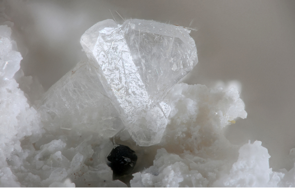


Squaw Creek Mine, Taylor Creek Mining District, Catron County, New Mexico, USA