Marsh Station vicinity, Pima County, Arizona, USAi
| Regional Level Types | |
|---|---|
| Marsh Station vicinity | - not defined - |
| Pima County | County |
| Arizona | State |
| USA | Country |
This page is currently not sponsored. Click here to sponsor this page.


Latitude & Longitude (WGS84):
32° 0' 58'' North , 110° 36' 21'' West
Latitude & Longitude (decimal):
Köppen climate type:
Nearest Settlements:
| Place | Population | Distance |
|---|---|---|
| Vail | 10,208 (2011) | 10.6km |
| Pimaco Two | 682 (2011) | 16.2km |
| Mescal | 1,812 (2011) | 16.3km |
| Corona de Tucson | 5,675 (2011) | 17.0km |
| Whetstone | 2,617 (2011) | 25.7km |
Nearest Clubs:
Local clubs are the best way to get access to collecting localities
Local clubs are the best way to get access to collecting localities
| Club | Location | Distance |
|---|---|---|
| Old Pueblo Lapidary Club | Tucson, Arizona | 38km |
| Tucson Gem and Mineral Society | Tucson, Arizona | 38km |
Mindat Locality ID:
293880
Long-form identifier:
mindat:1:2:293880:9
GUID (UUID V4):
b0a76290-4895-45a5-b774-a9bc908012c0
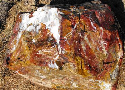
Marsh Station has had several names in the past, originally called Cienega Station and later also Pantano. The area goes back to 1858 when the Butterfield Overland mail built a station along its route here. In 1880 the railroad came through also and in 1912 the railroad bridge was built over Cienega Creek. The old East Marsh Station road was the original highway until the freeway was built. Now the road is mostly used by local residents. Along the road is the Remco Materials Gypsum Mine, at the east end of the road and on the north side. Farther west was a small copper mine which is visible from the road on the south side, now on protected land and a bit farther west, just past the small mine, a hill containing jasper which was used by the Native Americans for making tools. The area is now in the Cienega Creek Riparian Preserve and collecting and access are restricted. Hiking is permitted and parking is provided at the western end of the old road.
Select Mineral List Type
Standard Detailed Gallery Strunz Chemical ElementsCommodity List
This is a list of exploitable or exploited mineral commodities recorded from this region.Mineral List
Mineral list contains entries from the region specified including sub-localities4 valid minerals.
Detailed Mineral List:
| ⓘ Calcite Formula: CaCO3 References: |
| ⓘ 'Clay minerals' |
| ⓘ Gypsum Formula: CaSO4 · 2H2O Localities: References: |
| ⓘ Gypsum var. Satin Spar Gypsum Formula: CaSO4 · 2H2O |
| ⓘ Gypsum var. Selenite Formula: CaSO4 · 2H2O |
| ⓘ Hematite Formula: Fe2O3 Localities: References: |
| ⓘ Quartz Formula: SiO2 References: |
| ⓘ Quartz var. Chalcedony Formula: SiO2 References: |
| ⓘ Quartz var. Jasper References: |
Gallery:

List of minerals arranged by Strunz 10th Edition classification
| Group 4 - Oxides and Hydroxides | |||
|---|---|---|---|
| ⓘ | Hematite | 4.CB.05 | Fe2O3 |
| ⓘ | Quartz | 4.DA.05 | SiO2 |
| ⓘ | var. Chalcedony | 4.DA.05 | SiO2 |
| ⓘ | var. Jasper | 4.DA.05 | SiO2 |
| Group 5 - Nitrates and Carbonates | |||
| ⓘ | Calcite | 5.AB.05 | CaCO3 |
| Group 7 - Sulphates, Chromates, Molybdates and Tungstates | |||
| ⓘ | Gypsum | 7.CD.40 | CaSO4 · 2H2O |
| ⓘ | var. Satin Spar Gypsum | 7.CD.40 | CaSO4 · 2H2O |
| ⓘ | var. Selenite | 7.CD.40 | CaSO4 · 2H2O |
| Unclassified Minerals, Rocks, etc. | |||
| ⓘ | 'Clay minerals' | - | |
List of minerals for each chemical element
| H | Hydrogen | |
|---|---|---|
| H | ⓘ Gypsum | CaSO4 · 2H2O |
| H | ⓘ Gypsum var. Selenite | CaSO4 · 2H2O |
| H | ⓘ Gypsum var. Satin Spar Gypsum | CaSO4 · 2H2O |
| C | Carbon | |
| C | ⓘ Calcite | CaCO3 |
| O | Oxygen | |
| O | ⓘ Gypsum | CaSO4 · 2H2O |
| O | ⓘ Gypsum var. Selenite | CaSO4 · 2H2O |
| O | ⓘ Gypsum var. Satin Spar Gypsum | CaSO4 · 2H2O |
| O | ⓘ Quartz | SiO2 |
| O | ⓘ Calcite | CaCO3 |
| O | ⓘ Hematite | Fe2O3 |
| O | ⓘ Quartz var. Chalcedony | SiO2 |
| Si | Silicon | |
| Si | ⓘ Quartz | SiO2 |
| Si | ⓘ Quartz var. Chalcedony | SiO2 |
| S | Sulfur | |
| S | ⓘ Gypsum | CaSO4 · 2H2O |
| S | ⓘ Gypsum var. Selenite | CaSO4 · 2H2O |
| S | ⓘ Gypsum var. Satin Spar Gypsum | CaSO4 · 2H2O |
| Ca | Calcium | |
| Ca | ⓘ Gypsum | CaSO4 · 2H2O |
| Ca | ⓘ Gypsum var. Selenite | CaSO4 · 2H2O |
| Ca | ⓘ Gypsum var. Satin Spar Gypsum | CaSO4 · 2H2O |
| Ca | ⓘ Calcite | CaCO3 |
| Fe | Iron | |
| Fe | ⓘ Hematite | Fe2O3 |
Localities in this Region
- Arizona
- Pima County
- Marsh Station vicinity
- Pima County
Other Regions, Features and Areas containing this locality
Mexico
- Sierra Madre OccidentalMountain Range
North America
- Sonoran DesertDesert
North America PlateTectonic Plate
- Basin and Range BasinsBasin
- Mazatzal DomainDomain
This page contains all mineral locality references listed on mindat.org. This does not claim to be a complete list. If you know of more minerals from this site, please register so you can add to our database. This locality information is for reference purposes only. You should never attempt to
visit any sites listed in mindat.org without first ensuring that you have the permission of the land and/or mineral rights holders
for access and that you are aware of all safety precautions necessary.


Marsh Station vicinity, Pima County, Arizona, USA