Wellesweiler, Neunkirchen, Saar coal mining area, Saarland, Germanyi
| Regional Level Types | |
|---|---|
| Wellesweiler | - not defined - |
| Neunkirchen | - not defined - |
| Saar coal mining area | Area |
| Saarland | - not defined - |
| Germany | Country |


| Latitude & Longitude (WGS84): | 49° 20' 53'' North , 7° 13' 23'' East | ||||||||||||||||||
|---|---|---|---|---|---|---|---|---|---|---|---|---|---|---|---|---|---|---|---|
| Latitude & Longitude (decimal): | 49.34820,7.22311 | ||||||||||||||||||
| GeoHash: | G#: u0v0sredn | ||||||||||||||||||
| Köppen climate type: | Cfb : Temperate oceanic climate | ||||||||||||||||||
| Nearest Settlements: |
|
No description has been added for this locality. Can you add one?
Regions containing this locality
| Eurasian Plate | Tectonic Plate |
| Europe | Continent |
Select Mineral List Type
Standard Detailed Strunz Dana Chemical ElementsMineral List
Mineral list contains entries from the region specified including sub-localities4 valid minerals.
Detailed Mineral List:
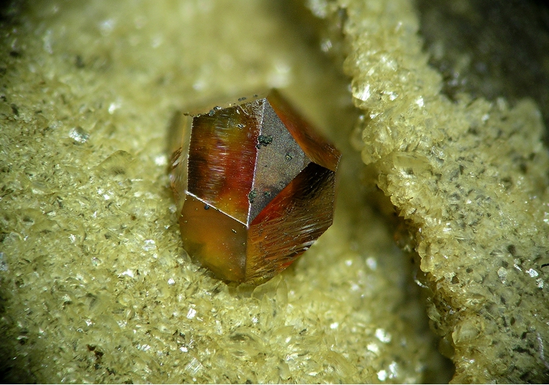
| ⓘ Chalcopyrite Formula: CuFeS2 Reference: in the collection of Joachim Esche |
ⓘ Millerite Formula: NiS Reference: in the collection of Joachim Esche |
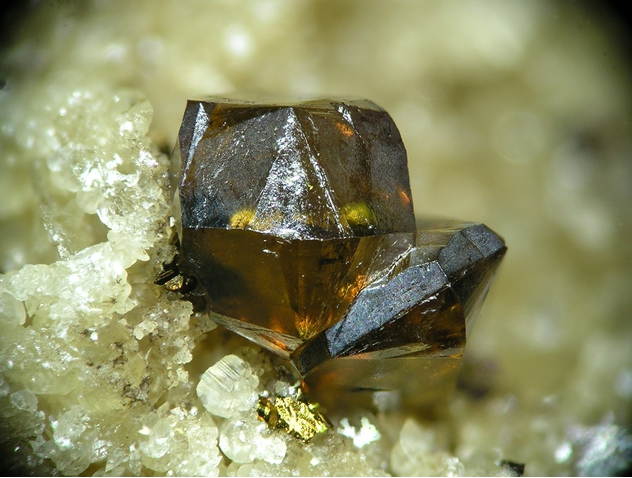
| ⓘ Siderite Formula: FeCO3 Reference: in the collection of Joachim Esche |
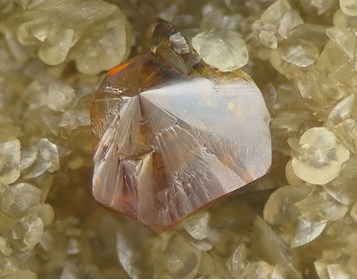
ⓘ Sphalerite Formula: ZnS Reference: in the collection of Joachim Esche |

List of minerals arranged by Strunz 10th Edition classification
| Group 2 - Sulphides and Sulfosalts | |||
|---|---|---|---|
| ⓘ | Chalcopyrite | 2.CB.10a | CuFeS2 |
| ⓘ | Millerite | 2.CC.20 | NiS |
| ⓘ | Sphalerite | 2.CB.05a | ZnS |
| Group 5 - Nitrates and Carbonates | |||
| ⓘ | Siderite | 5.AB.05 | FeCO3 |
List of minerals arranged by Dana 8th Edition classification
| Group 2 - SULFIDES | |||
|---|---|---|---|
| AmXp, with m:p = 1:1 | |||
| ⓘ | Millerite | 2.8.16.1 | NiS |
| ⓘ | Sphalerite | 2.8.2.1 | ZnS |
| AmBnXp, with (m+n):p = 1:1 | |||
| ⓘ | Chalcopyrite | 2.9.1.1 | CuFeS2 |
| Group 14 - ANHYDROUS NORMAL CARBONATES | |||
| A(XO3) | |||
| ⓘ | Siderite | 14.1.1.3 | FeCO3 |
List of minerals for each chemical element
| C | Carbon | |
|---|---|---|
| C | ⓘ Siderite | FeCO3 |
| O | Oxygen | |
| O | ⓘ Siderite | FeCO3 |
| S | Sulfur | |
| S | ⓘ Millerite | NiS |
| S | ⓘ Sphalerite | ZnS |
| S | ⓘ Chalcopyrite | CuFeS2 |
| Fe | Iron | |
| Fe | ⓘ Siderite | FeCO3 |
| Fe | ⓘ Chalcopyrite | CuFeS2 |
| Ni | Nickel | |
| Ni | ⓘ Millerite | NiS |
| Cu | Copper | |
| Cu | ⓘ Chalcopyrite | CuFeS2 |
| Zn | Zinc | |
| Zn | ⓘ Sphalerite | ZnS |
Regional Geology
This geological map and associated information on rock units at or nearby to the coordinates given for this locality is based on relatively small scale geological maps provided by various national Geological Surveys. This does not necessarily represent the complete geology at this locality but it gives a background for the region in which it is found.
Click on geological units on the map for more information. Click here to view full-screen map on Macrostrat.org
| Anisian - Late Permian 242 - 272.95 Ma ID: 2609881 | Age: Phanerozoic (242 - 272.95 Ma) Description: limnic - fluvial to brackish deposits Lithology: Sandstone, conglomerate Reference: Toloczyki, M., P. Trurnit, A. Voges, H. Wittekindt, A. Zitzmann. Geological Map of Germany 1:M. Bundesanstalt für Geowissenschaften und Rohstoffe. [94] |
| Early Triassic 247.2 - 251.902 Ma ID: 3162695 | Early Triassic sandstone Age: Early Triassic (247.2 - 251.902 Ma) Lithology: Major:{sandstone}, Minor{conglomerate,mudstone,siltstone} Reference: Asch, K. The 1:5M International Geological Map of Europe and Adjacent Areas: Development and Implementation of a GIS-enabled Concept. Geologisches Jahrbuch, SA 3. [147] |
| Devonian 358.9 - 419.2 Ma ID: 3186341 | Paleozoic sedimentary rocks Age: Devonian (358.9 - 419.2 Ma) Lithology: Sedimentary rocks Reference: Chorlton, L.B. Generalized geology of the world: bedrock domains and major faults in GIS format: a small-scale world geology map with an extended geological attribute database. doi: 10.4095/223767. Geological Survey of Canada, Open File 5529. [154] |
Data and map coding provided by Macrostrat.org, used under Creative Commons Attribution 4.0 License
Localities in this RegionShow map
- Saarland
- Saar coal mining area
- Neunkirchen
- Wellesweiler
- Neunkirchen
- Saar coal mining area


Wellesweiler Mine, Wellesweiler, Neunkirchen, Saar coal mining area, Saarland, Germany