Atlin-Ruffner Mine, Atlin Mining Division, British Columbia, Canadai
| Regional Level Types | |
|---|---|
| Atlin-Ruffner Mine | Mine |
| Atlin Mining Division | Division |
| British Columbia | Province |
| Canada | Country |
This page is currently not sponsored. Click here to sponsor this page.
Latitude & Longitude (WGS84):
59° 44' 8'' North , 133° 31' 18'' West
Latitude & Longitude (decimal):
Locality type:
Köppen climate type:
A Au-Ag-Pb-Zn deposit in shear zone of lamprophyre dykes. Operated between 1921 and 1933
I05 : Polymetallic veins Ag-Pb-Zn+/-Au
The Atlin-Ruffner mine, composed primarily of the Ruffner and Big Canyon claim groups, is located on Crater Creek which drains west into the Fourth of July Creek. The mine is about 23 kilometres northeast of Atlin, British Columbia.
The following quote is from B.C. Government site “Minfile”- Minfile No. 104N 001, current to 2015:
“The occurrence lies completely within the Middle Jurassic Fourth of July Creek batholith which covers about 780 square kilometres northeast of Atlin. It is composed of both monzonitic and quartz dioritic phases and in the area of the Atlin Ruffner mine is composed of feldspar porphyritic quartz syenite to granite. The batholith has intruded into Carboniferous-Jurassic Cache Creek Complex rocks.
Mineralization on the property is associated with dark green, pyroxene-bearing lamprophyre dikes which strike 070 degrees and dip 85 degrees to the northwest. The dikes are abundant, parallel and from 2 to 10 metres thick. They follow older fracture zones and have been the host for younger fracturing, shearing and veining. The dikes are not commonly seen outside the batholith and have also been crosscut by the younger, Late Cretaceous Surprise Lake batholith. These relationships suggest that the mafic dikes may be in part coeval with the Jurassic Fourth of July Creek batholith and represent a residual, differentiated mafic portion of the same parent magma emplaced only slightly after the main body.
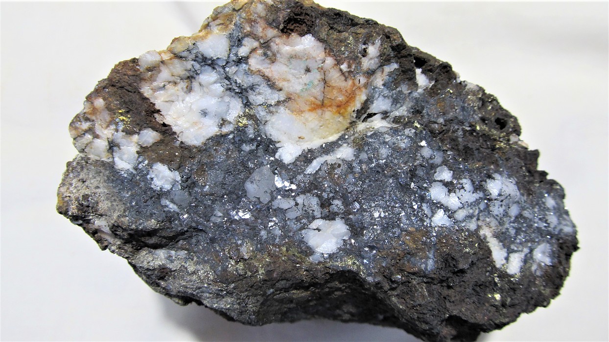
Possibly because of their brittle more competent nature, the dikes host later shearing, veining and fracturing. Four of these dikes are replaced by ankerite-quartz-calcite veining and shear zones. They are heavily mineralized with galena, sphalerite and arsenopyrite with lesser pyrite and chalcopyrite. Mineralization is lensy and not laterally continuous. Ore has been produced from these structures from 1916 to 1981 with an average grade of 0.42 gram per tonne gold, 267 grams per tonne silver and 5 per cent combined lead-zinc. Mineralization occurs in four major zones (Assessment Report 18646).
The dikes usually host the mineralization, and clearly predate the mineralization, as in many cases brecciated dike rock fragments are found in the quartz-carbonate-sulphide assemblages that constitute the ore. Mineralization includes varying amounts of sphalerite, galena, arsenopyrite, pyrite, pyrrhotite, chalcopyrite, pyrargyrite (with trace amounts of tetrahedrite, molybdenite, scheelite, and cassiterite) in a quartz-calcite gangue. Across the mineralized veins/shears,which typically are 1 to 2 metres in width, there is a crude segregation of sulphide mineralogy, from sphalerite-rich hangingwall, through a galena-rich core, to an arsenopyrite-rich footwall. High grade silver values are commonly associated with galena-rich zones, and gold values with arsenopyrite-rich zones. Four major vein/shear systems have been identified to date, with underground development and production having taken place on two of them.”
Comments by Giles Peatfield regarding some of the minerals reported:
Argyrodite: Rebagliati (1962) reported traces of argyrodite, with tennantite, proustite and galena. He based his identification on microscopy and etch tests. There was no X-ray confirmation. I would regard this as tentative for the locality.
Bornite: This was reported only by Buckland (1931), occurring in one of his polished sections of material from near surface. He regarded it as a secondary mineral. I would regard it as valid for the locality.
Cassiterite: The only available reference to cassiterite at Atlin-Ruffner is by McIvor (1989), who gave no details. Given the regional geological setting, I would regard it as possible, but tentative for the locality.
Covellite: The only reference for covellite was by Rebagliati (1962), who identified it based on micrography and etch tests. I would regard it as valid for the locality.
Enargite: Smith (1974) noted that Dr. J. A. Chamberlain of the consulting firm Dolmage, Campbell and Associates, in an unpublished report dated February 05 1969, identified several minerals, including enargite. I am prepared to accept the mineral as valid for the locality.
Fluorite: Gordy (1955) reported fluorite in quartz specimens, but was not certain that these were actually from the property. Dr. R. M. Thompson’s comment was “Why not?” Given this, and the general geology of the region, I would regard fluorite as probable for the locality.
Gold: Gordy (1955) was the only one to report native gold, which he found in one of his polished sections. He noted that “The color of the gold is pale yellow, possibly indicating a relatively high silver content.”
Molybdenite: Gordy (1955) reported molybdenite in one quartz specimen, and had the same thought as for fluorite. The mineral was also reported by McIvor (1989) – I would regard it as valid for the locality.
Proustite: Rebagliati (1962) identified proustite based on micrography and etch tests. I would regard it as valid for the locality.
Scheelite: The only available reference to scheelite at Atlin-Ruffner is by McIvor (1989), who gave no details. Given the regional geological setting, I would regard it as possible, but tentative for the locality.
Silver (native): The only reference to native silver is in a fragment of a report (B.C. Minfile PF020045), anonymous and un-dated. I would regard this as tentative for the locality.
Stannite?: Gordy (1955) reported stannite, basing his identification on microscopy and etch tests. Dr. R. M. Thompson’s comment was “require[s] X-ray confirmation. I would regard it as possible for the locality.
Stephanite?: Gordy (1955) reported stephanite, basing his identification on microscopy and etch tests. Dr. R. M. Thompson’s comment was “require[s] X-ray confirmation. I would regard it as possible for the locality.
Sternbergite?: Rebagliati (1962) tentatively identified sternbergite based on micrography and etch tests, but was uncertain because of a lack of reaction to HCl, which Short (1940) listed as characteristic for the mineral. Dr. R. M. Thompson appears to have approved the identification. I would regard it as possible for the locality.
Tennantite: Rebagliati (1962) identified tennantite based on micrography and etch tests, adding that a microchemical test for As was positive whereas that for Sb was “very very weak to negative.” I would class this as probable for the locality, although Rebagliati also mentioned tetrahedrite, which was reported by several other workers.
Comments by Giles Peatfield regarding some of the rock types reported:
Aplite: Donaldson (1953) and Gordy (1955) both described small aplite dykes in the area of mineralization.
Granite: Cockfield (1926) described the principal intrusive rock as “granite”, and gave a detailed description. Later workers have reported “diorite and granodiorite” (Bloodgood et al., 1989) or “quartz diorite and diorite” (Donaldson, 1953; Gordy, 1955), or “quartz monzonite” (Aitken, 1959), or other names (see Minfile quote above), but I think it would seem best to retain Cockfield’s original name.
Hornblende lamprophyre: Cockfield (1926) described the dyke rocks in some detail, and applied the name “hornblende lamprophyre”. Other have described the dyke rocks as “dioritic to diabasic” (Bloodgood, et al. 1989), or as “andesite dykes” (Rebagliati, 1962). I would prefer to retain Cockfield’s name.
Select Mineral List Type
Standard Detailed Gallery Strunz Chemical ElementsMineral List
25 valid minerals.
Rock Types Recorded
Note: data is currently VERY limited. Please bear with us while we work towards adding this information!
Select Rock List Type
Alphabetical List Tree DiagramDetailed Mineral List:
| ⓘ Ankerite Formula: Ca(Fe2+,Mg)(CO3)2 Reference: Sabina, A.P. (1972) Rocks & minerals for the collector: The Alaska Highway, Dawson Creek, British Columbia to Yukon/Alaska border. GSC paper 72-32, 65.; Minfile Database (2017) |
| ⓘ Argyrodite Formula: Ag8GeS6 Reference: personal correspondence with Giles Peatfield |
| ⓘ Arsenopyrite Formula: FeAsS Reference: Sabina, A.P. (1972) Rocks & minerals for the collector: The Alaska Highway, Dawson Creek, British Columbia to Yukon/Alaska border. GSC paper 72-32, 65.; Minfile Database (2017) |
| ⓘ Bornite Formula: Cu5FeS4 Reference: personal correspondence with Giles Peatfield |
| ⓘ Calcite Formula: CaCO3 Reference: Sabina, A.P. (1972) Rocks & minerals for the collector: The Alaska Highway, Dawson Creek, British Columbia to Yukon/Alaska border. GSC paper 72-32, 65.; Minfile Database (2017) |
| ⓘ Cassiterite Formula: SnO2 Reference: Minfile Database (2017) |
| ⓘ Chalcopyrite Formula: CuFeS2 Reference: Sabina, A.P. (1972) Rocks & minerals for the collector: The Alaska Highway, Dawson Creek, British Columbia to Yukon/Alaska border. GSC paper 72-32, 65.; Minfile Database (2017) |
| ⓘ Covellite Formula: CuS Reference: personal correspondence with Giles Peatfield |
| ⓘ Enargite Formula: Cu3AsS4 Reference: personal correspondence with Giles Peatfield |
| ⓘ Fluorite Formula: CaF2 Reference: personal correspondence with Giles Peatfield |
| ⓘ Galena Formula: PbS Reference: Sabina, A.P. (1972) Rocks & minerals for the collector: The Alaska Highway, Dawson Creek, British Columbia to Yukon/Alaska border. GSC paper 72-32, 65.; Minfile Database (2017)
personal correspondence with Giles Peatfield |
| ⓘ Gold Formula: Au Reference: Minfile Database (2017) |
| ⓘ 'Hornblende' Reference: personal correspondence with Giles Peatfield |
| ⓘ Marcasite Formula: FeS2 Reference: personal correspondence with Giles Peatfield |
| ⓘ Molybdenite Formula: MoS2 Reference: Minfile Database (2017) |
| ⓘ Proustite Formula: Ag3AsS3 Reference: personal correspondence with Giles Peatfield |
| ⓘ Pyrargyrite Formula: Ag3SbS3 Reference: Minfile Database (2017) |
| ⓘ Pyrite Formula: FeS2 Reference: Sabina, A.P. (1972) Rocks & minerals for the collector: The Alaska Highway, Dawson Creek, British Columbia to Yukon/Alaska border. GSC paper 72-32, 65.; Minfile Database (2017) |
| ⓘ 'Pyroxene Group' Formula: ADSi2O6 Reference: Minfile Database (2017) |
| ⓘ Pyrrhotite Formula: Fe1-xS Reference: Minfile Database (2017) |
| ⓘ Quartz Formula: SiO2 Reference: Sabina, A.P. (1972) Rocks & minerals for the collector: The Alaska Highway, Dawson Creek, British Columbia to Yukon/Alaska border. GSC paper 72-32, 65.; Minfile Database (2017) |
| ⓘ Scheelite Formula: Ca(WO4) Reference: Minfile Database (2017) |
| ⓘ Silver Formula: Ag Reference: personal correspondence with Giles Peatfield |
| ⓘ Sphalerite Formula: ZnS Reference: Sabina, A.P. (1972) Rocks & minerals for the collector: The Alaska Highway, Dawson Creek, British Columbia to Yukon/Alaska border. GSC paper 72-32, 65.; Minfile Database (2017) |
| ⓘ Stannite ? Formula: Cu2FeSnS4 Reference: personal correspondence with Giles Peatfield |
| ⓘ Stephanite ? Formula: Ag5SbS4 Reference: personal correspondence with Giles Peatfield |
| ⓘ Sternbergite ? Formula: AgFe2S3 Reference: personal correspondence with Giles Peatfield |
| ⓘ 'Tetrahedrite Subgroup' Formula: Cu6(Cu4C2+2)Sb4S12S Reference: Minfile Database (2017) |
Gallery:
List of minerals arranged by Strunz 10th Edition classification
| Group 1 - Elements | |||
|---|---|---|---|
| ⓘ | Gold | 1.AA.05 | Au |
| ⓘ | Silver | 1.AA.05 | Ag |
| Group 2 - Sulphides and Sulfosalts | |||
| ⓘ | Argyrodite | 2.BA.70 | Ag8GeS6 |
| ⓘ | Arsenopyrite | 2.EB.20 | FeAsS |
| ⓘ | Bornite | 2.BA.15 | Cu5FeS4 |
| ⓘ | Chalcopyrite | 2.CB.10a | CuFeS2 |
| ⓘ | Covellite | 2.CA.05a | CuS |
| ⓘ | Enargite | 2.KA.05 | Cu3AsS4 |
| ⓘ | Galena | 2.CD.10 | PbS |
| ⓘ | Marcasite | 2.EB.10a | FeS2 |
| ⓘ | Molybdenite | 2.EA.30 | MoS2 |
| ⓘ | Proustite | 2.GA.05 | Ag3AsS3 |
| ⓘ | Pyrargyrite | 2.GA.05 | Ag3SbS3 |
| ⓘ | Pyrite | 2.EB.05a | FeS2 |
| ⓘ | Pyrrhotite | 2.CC.10 | Fe1-xS |
| ⓘ | Sphalerite | 2.CB.05a | ZnS |
| ⓘ | Stannite ? | 2.CB.15a | Cu2FeSnS4 |
| ⓘ | Stephanite ? | 2.GB.10 | Ag5SbS4 |
| ⓘ | Sternbergite ? | 2.CB.65 | AgFe2S3 |
| ⓘ | 'Tetrahedrite Subgroup' | 2.GB.05 | Cu6(Cu4C2+2)Sb4S12S |
| Group 3 - Halides | |||
| ⓘ | Fluorite | 3.AB.25 | CaF2 |
| Group 4 - Oxides and Hydroxides | |||
| ⓘ | Cassiterite | 4.DB.05 | SnO2 |
| ⓘ | Quartz | 4.DA.05 | SiO2 |
| Group 5 - Nitrates and Carbonates | |||
| ⓘ | Ankerite | 5.AB.10 | Ca(Fe2+,Mg)(CO3)2 |
| ⓘ | Calcite | 5.AB.05 | CaCO3 |
| Group 7 - Sulphates, Chromates, Molybdates and Tungstates | |||
| ⓘ | Scheelite | 7.GA.05 | Ca(WO4) |
| Unclassified Minerals, Rocks, etc. | |||
| ⓘ | 'Hornblende' | - | |
| ⓘ | 'Pyroxene Group' | - | ADSi2O6 |
List of minerals for each chemical element
References
Sort by
Year (asc) Year (desc) Author (A-Z) Author (Z-A)Additional references for the Atlin-Ruffner mine can be found in Minfile. The following are those from which details of mineralogy were taken.
Aitken, J. D. 1959. Atlin Map-Area British Columbia (104N). Geological Survey of Canada, Memoir 307.
Bloodgood, M. A., Rees, C. J. and Lefebure, D. V. 1989. Geology and Mineralization of the Atlin Area, Northwestern British Columbia (104N/11W and 12E). British Columbia Ministry of Energy, Mines and Petroleum Resources, Geological Fieldwork, 1988, Paper 1989-1.
Buckland, F. C. 1931. The Atlin Ruffner Lead Silver Mine, A Report on Mineralography. Course report, University of British Columbia. British Columbia “Minfile” PF 600020.
Cockfield, W. E. 1926. Silver-Lead Deposits in Atlin District, B. C., in Summary Report 1925, Part A, pp. 15-24. Canada, Department of Mines, Geological Survey.
Donaldson, T. J. 1953. A Mineralographic Report of the Ores of the Atlin Ruffner Mine, Atlin, B. C. Course report, University of British Columbia. British Columbia “Minfile” PF 600018.
Gordy, P. L. 1955. A Mineralographic Study of Atlin Ruffner Ores. Course report, University of British Columbia. British Columbia “Minfile” PF 600019.
McIvor, Duncan. 1989. The Results of a Mineral Exploration Program on the Mount Vaughan Property. British Columbia Ministry of Energy, Mines and Petroleum Resources, Geological Survey Branch. Assessment Report 18,646.
Sabina, A.P. (1972) Rocks & minerals for the collector: The Alaska Highway, Dawson Creek, British Columbia to Yukon/Alaska border. GSC paper 72-32, 65.
Other Databases
| Link to British Columbia Minfile: | 104N 011 |
|---|
Other Regions, Features and Areas containing this locality
This page contains all mineral locality references listed on mindat.org. This does not claim to be a complete list. If you know of more minerals from this site, please register so you can add to our database. This locality information is for reference purposes only. You should never attempt to
visit any sites listed in mindat.org without first ensuring that you have the permission of the land and/or mineral rights holders
for access and that you are aware of all safety precautions necessary.


Atlin-Ruffner Mine, Atlin Mining Division, British Columbia, Canada