Shotgun Creek, Lane Co., Oregon, USA
This page is currently not sponsored. Click here to sponsor this page.


| Latitude & Longitude (WGS84): | 44° 14' 44'' North , 122° 54' 6'' West |
|---|---|
| Latitude & Longitude (decimal): | 44.2458333333, -122.901944444 |
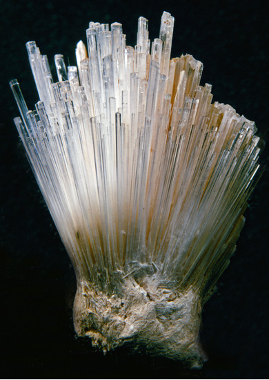
Two zeolite localities that are found only 100 meters apart in the Shotgun Creek drainage system are near the crest of a hill which divides Lane with Linn Counties, therefore, each site is in a different county. The one in the Lane County is composed of highly altered Eocene basalt with pockets of coarse mesolite needles. Dan Lorimor and Boyd Care found the site in the earily 1960's. At that time the finest specimen of mesolite found in Oregon was exposed in the bank of the Weyerhaeuser logging road. Other specimens were found in boulders from the roadcut and from digging in the soil in the roadcut in 1972 by Rudy Tschernich. This site is now lost. Second growth trees have been logged and new roads were made without exposing this old road.
Rudy Tschernich
Mineral List
1 valid mineral.
This page contains all mineral locality references listed on mindat.org. This does not claim to be a complete list. If you know of more minerals from this site, please register so you can add to our database. This locality information is for reference purposes only. You should never attempt to
visit any sites listed in mindat.org without first ensuring that you have the permission of the land and/or mineral rights holders
for access and that you are aware of all safety precautions necessary.
References
Tschernich, R.W. (1992) Zeolites of the World. Geoscience Press. Phoenix, Arizona.


Shotgun Creek, Lane Co., Oregon, USA