| Locality | Latitude | Longitude | Distance | Bearing |
|---|
| High Bluff Gravel Pit, Lady Long - Big Pole Area, Wasatch County, Utah, USA | 40° 36' 6" N | 111° 17' 44" W | 1.8km (1.1 miles) | |
| Webb Hollow Mine, Lady Long - Big Pole Area, Wasatch County, Utah, USA | 40° 33' 56" N | 111° 17' 21" W | 2.3km (1.4 miles) | |
| Woodland, Summit County, Utah, USA | 40° 34' 53" N | 111° 13' 37" W | 5.1km (3.2 miles) | |
| Moon Canyon, Woodland, Summit County, Utah, USA | 40° 37' 18" N | 111° 13' 51" W | 6.2km (3.8 miles) | |
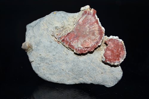
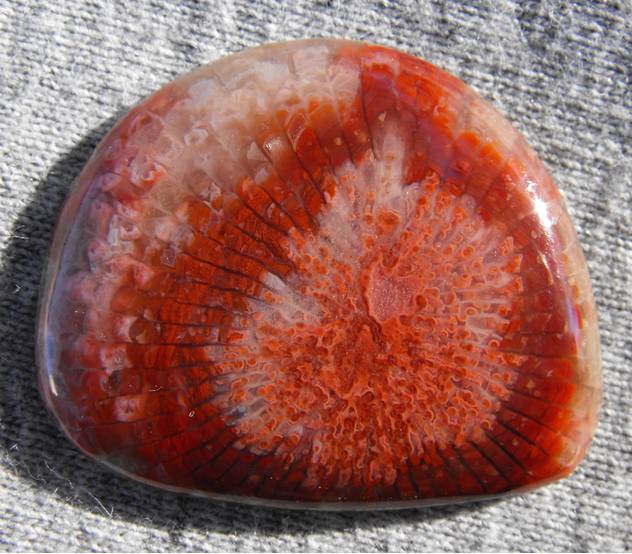
| Woodland Quarry, Woodland, Summit County, Utah, USA | 40° 34' 42" N | 111° 12' 47" W | 6.3km (3.9 miles) | |
| Rileys Canyon, Woodland, Summit County, Utah, USA | 40° 34' 5" N | 111° 11' 39" W | 8.1km (5.1 miles) | |
| Exploration Investment Quarry, Woodland, Summit County, Utah, USA | 40° 35' 14" N | 111° 11' 22" W | 8.2km (5.1 miles) | |
| Beaver Canyon, Beaver Creek, Summit County, Utah, USA | 40° 37' 47" N | 111° 11' 42" W | 9.2km (5.7 miles) | |
| Murdock Hollow NE Adit Occurrence, Park City Mining District, Wasatch Mountains, Wasatch County, Utah, USA | 40° 38' 8" N | 111° 22' 32" W | 9.3km (5.8 miles) | |
| Murdock Hollow Prospects, Elkhorn Mining District, Wasatch County, Utah, USA | 40° 37' 36" N | 111° 23' 21" W | 9.7km (6.0 miles) | |
| Park Konold Mine, Elkhorn Mining District, Wasatch County, Utah, USA | 40° 37' 32" N | 111° 23' 29" W | 9.8km (6.1 miles) | |
| Queen Mine, Elkhorn Mining District, Wasatch County, Utah, USA | 40° 37' 24" N | 111° 23' 43" W | 10.0km (6.2 miles) | |
| Lucky Strike Nos. 1 - 4 ; 6 Occurrence, Woodland, Summit County, Utah, USA | 40° 34' 59" N | 111° 10' 0" W | 10.2km (6.3 miles) | |
| Gold Bullion Nos. 1 - 5 Occurrence, Woodland, Summit County, Utah, USA | 40° 36' 0" N | 111° 10' 0" W | 10.3km (6.4 miles) | |
| Chuck Nos. 1 - 6 ; 8 - 15 Occurrence, Woodland, Summit County, Utah, USA | 40° 36' 0" N | 111° 10' 0" W | 10.3km (6.4 miles) | |
| Bone Hollow Claims, Elkhorn Mining District, Wasatch County, Utah, USA | 40° 37' 37" N | 111° 23' 55" W | 10.4km (6.5 miles) | |
| Timber Lakes Quarries, Lake Creek Area, Wasatch County, Utah, USA | 40° 29' 40" N | 111° 18' 46" W | 10.4km (6.5 miles) | |
| Park Premier Shaft, Elkhorn Mining District, Wasatch County, Utah, USA | 40° 36' 57" N | 111° 24' 18" W | 10.5km (6.5 miles) | |
| Utah Silver Nos. 1; 2; 5; 7; 8; 23; 24 Occurrence, Woodland, Summit County, Utah, USA | 40° 37' 0" N | 111° 10' 0" W | 10.7km (6.7 miles) | |
| Keetley Prospect, Park City Mining District, Wasatch Mountains, Wasatch County, Utah, USA | 40° 38' 16" N | 111° 24' 28" W | 11.6km (7.2 miles) | |
| Cottonwood Canyon Stone Quarry, Park City Mining District, Wasatch Mountains, Wasatch County, Utah, USA | 40° 34' 44" N | 111° 25' 50" W | 12.1km (7.5 miles) | |
| Weber Quartzite Road Cut, Park City Mining District, Summit County, Utah, USA | 40° 36' 47" N | 111° 25' 47" W | 12.4km (7.7 miles) | |
| Sphinx Prospect, Park City Mining District, Wasatch Mountains, Wasatch County, Utah, USA | 40° 35' 48" N | 111° 26' 2" W | 12.4km (7.7 miles) | |
| Keeler Tunnel, Park City Mining District, Wasatch Mountains, Wasatch County, Utah, USA | 40° 37' 0" N | 111° 25' 45" W | 12.4km (7.7 miles) | |
| Cunningham Tunnel, Park City Mining District, Wasatch Mountains, Wasatch County, Utah, USA | 40° 37' 1" N | 111° 26' 0" W | 12.8km (8.0 miles) | |
| East Utah Shaft (Minnie Claim; East Utah Group), Park City Mining District, Wasatch Mountains, Wasatch County, Utah, USA | 40° 37' 41" N | 111° 25' 59" W | 13.2km (8.2 miles) | |
| Mayflower Mine, Park City Mining District, Summit County, Utah, USA | 40° 36' 59" N | 111° 26' 28" W | 13.4km (8.3 miles) | |
| Central Cottonwood Canyon Prospects, Park City Mining District, Wasatch Mountains, Wasatch County, Utah, USA | 40° 35' 21" N | 111° 26' 56" W | 13.6km (8.5 miles) | |
| Blue Ledge-Mayflower Mine, Park City Mining District, Wasatch Mountains, Wasatch County, Utah, USA | 40° 34' 59" N | 111° 27' 0" W | 13.7km (8.5 miles) | |
| Ross Todd Hollow Adit, Park City Mining District, Wasatch Mountains, Wasatch County, Utah, USA | 40° 40' 2" N | 111° 24' 46" W | 13.9km (8.6 miles) | |
Minerals recorded nearby (within 13.9 km)
Rock types recorded nearby (within 13.9 km)
Entries shown in red are rocks recorded for this region.


Woodland Quarry, Woodland, Summit County, Utah, USA