| Locality | Latitude | Longitude | Distance | Bearing |
|---|
| California City, Kern County, California, USA | 35° 7' 32" N | 117° 59' 5" W | 0.1km (0.1 miles) | |
| Fremont Valley, Kern County, California, USA | 35° 6' 29" N | 118° 2' 48" W | 5.9km (3.7 miles) | |
| Unnamed stone quarry [2] (Broken stone No. 5), California City, Kern County, California, USA | 35° 4' 27" N | 117° 55' 38" W | 7.8km (4.8 miles) | |
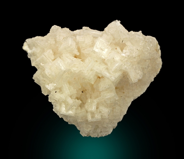
| Castle Butte, California City, Kern County, California, USA | 35° 6' 51" N | 117° 52' 36" W | 10.0km (6.2 miles) | |
| M A K prospect, Castle Butte, California City, Kern County, California, USA | 35° 7' 15" N | 117° 52' 10" W | 10.6km (6.6 miles) | |
| Nob Hill prospect (Knob Hill U prospect), Castle Butte, California City, Kern County, California, USA | 35° 7' 14" N | 117° 52' 3" W | 10.8km (6.7 miles) | |
| Unnamed stone quarry [3] (Broken Stone No. 3), Castle Butte, California City, Kern County, California, USA | 35° 2' 42" N | 117° 52' 47" W | 13.2km (8.2 miles) | |
| Pine Tree Canyon (Lone Tree Canyon), Chuckwalla Mountain, Kern County, California, USA | 35° 14' 9" N | 118° 4' 8" W | 14.4km (8.9 miles) | |
| Pine Canyon (Pine Tree Canyon ?), Chuckwalla Mountain, Kern County, California, USA | 35° 14' 9" N | 118° 4' 8" W | 14.4km (8.9 miles) | |
| Bissell, Kern County, California, USA | 34° 59' 40" N | 118° 0' 5" W | 14.6km (9.1 miles) | |
| Tehachapi Clay Mine, Mojave, Mojave-Rosamond Mining District (Mojave Mining District), Kern County, California, USA | 35° 5' 8" N | 118° 8' 48" W | 15.3km (9.5 miles) | |
| Cinco, Fremont Valley, Kern County, California, USA | 35° 15' 47" N | 118° 2' 7" W | 15.9km (9.9 miles) | |
| Bissell Magnesite deposit, Bissell, Kern County, California, USA | 34° 58' 59" N | 118° 0' 33" W | 16.0km (10.0 miles) | |
| Broken Stone No. 4 (Broken Stone #4), Mojave, Mojave-Rosamond Mining District (Mojave Mining District), Kern County, California, USA | 35° 7' 22" N | 118° 10' 4" W | 16.5km (10.3 miles) | |
| Boron Dry Lakes, Boron, Kern County, California, USA | 35° 4' 27" N | 117° 48' 51" W | 16.6km (10.3 miles) | |
| Unnamed Clay deposit [3] (Clay Deposit No. 3), Cinco, Fremont Valley, Kern County, California, USA | 35° 16' 26" N | 118° 1' 3" W | 16.7km (10.4 miles) | |
| Ladd Mine, Sanborn, Mojave-Rosamond Mining District (Mojave Mining District), Kern County, California, USA | 35° 0' 29" N | 118° 6' 11" W | 16.9km (10.5 miles) | |
| Peerless Valley, Kern County, California, USA | 35° 5' 59" N | 117° 48' 3" W | 17.1km (10.6 miles) | |
| Amalia Mine (Cowboy No. 1), Chuckwalla Mountain, Kern County, California, USA | 35° 15' 12" N | 118° 5' 27" W | 17.1km (10.6 miles) | |
| Carbonate prospect, Chuckwalla Mountain, Kern County, California, USA | 35° 16' 21" N | 118° 2' 29" W | 17.1km (10.6 miles) | |
| Tardy prospect (Tardy claims), Chuckwalla Mountain, Kern County, California, USA | 35° 15' 55" N | 118° 4' 2" W | 17.2km (10.7 miles) | |
| Sanborn, Mojave-Rosamond Mining District (Mojave Mining District), Kern County, California, USA | 35° 0' 1" N | 118° 6' 23" W | 17.7km (11.0 miles) | |
| Miller prospect, Pajuela Peak, Kern County, California, USA | 35° 9' 55" N | 118° 10' 45" W | 18.1km (11.3 miles) | |
| Aerial Acres, Peerless Valley, Kern County, California, USA | 35° 5' 15" N | 117° 47' 31" W | 18.1km (11.3 miles) | |
| Unnamed stone quarry [5] (Broken Stone No. 1), Mojave, Mojave-Rosamond Mining District (Mojave Mining District), Kern County, California, USA | 35° 7' 3" N | 118° 11' 7" W | 18.2km (11.3 miles) | |
| Unnamed Quartz occurrence [1], Chuckwalla Mountain, Kern County, California, USA | 35° 16' 54" N | 118° 2' 47" W | 18.2km (11.3 miles) | |
| Mammouth prospect (Mammoth prospect), Chuckwalla Mountain, Kern County, California, USA | 35° 15' 18" N | 118° 6' 41" W | 18.3km (11.4 miles) | |
| North Edwards (Edgemont Acres; North Muroc), Kern County, California, USA | 35° 0' 59" N | 117° 49' 58" W | 18.5km (11.5 miles) | |
| Undetermined Hg occurrence [3], Chuckwalla Mountain, Kern County, California, USA | 35° 17' 23" N | 118° 1' 55" W | 18.7km (11.6 miles) | |
| Unnamed Hg occurrence [1], Chuckwalla Mountain, Kern County, California, USA | 35° 17' 24" N | 118° 1' 55" W | 18.7km (11.6 miles) | |
Minerals recorded nearby (within 18.7 km)
Rock types recorded nearby (within 18.7 km)
Entries shown in red are rocks recorded for this region.


Castle Butte, California City, Kern County, California, USA