| Locality | Latitude | Longitude | Distance | Bearing |
|---|
| Coal Pit Lane Quarry (Lower Enderbury Quarry), Enderby, Blaby, Leicestershire, England, UK | 52° 35' 14" N | 1° 12' 7" W | 2.3km (1.4 miles) | |
| Butterley & Blaby Brick Pit (Blaby Mine), Glen Parva, Leicester, Leicestershire, England, UK | 52° 34' 59" N | 1° 10' 13" W | 2.7km (1.7 miles) | |
| Croft and Huncote Quarry, Croft, Blaby, Leicestershire, England, UK | 52° 33' 42" N | 1° 14' 30" W | 2.9km (1.8 miles) | |
| Huncote Quarry, Huncote, Blaby, Leicestershire, England, UK | 52° 34' 0" N | 1° 14' 35" W | 2.9km (1.8 miles) | |
| Enderby Hill Quarry, Enderby, Blaby, Leicestershire, England, UK | 52° 35' 29" N | 1° 12' 52" W | 2.9km (1.8 miles) | |
| Enderby Warren Quarry, Enderby, Blaby, Leicestershire, England, UK | 52° 35' 41" N | 1° 12' 14" W | 3.2km (2.0 miles) | |
| Glen Parva, Leicester, Leicestershire, England, UK | 52° 35' 2" N | 1° 9' 15" W | 3.6km (2.3 miles) | |
| Asquith Boulevard, Thurlaston, Blaby, Leicestershire, England, UK | 52° 35' 44" N | 1° 15' 42" W | 5.3km (3.3 miles) | |
| Oadby, Oadby and Wigston, Leicestershire, England, UK | 52° 36' 6" N | 1° 4' 43" W | 9.1km (5.6 miles) | |
| Barwell meteorite, Barwell, Hinckley and Bosworth, Leicestershire, England, UK | 52° 33' 55" N | 1° 20' 22" W | 9.4km (5.9 miles) | |
| Lindridge Colliery, Hinckley and Bosworth, Leicestershire, England, UK | 52° 38' 11" N | 1° 18' 13" W | 10.5km (6.5 miles) | |
| Sheet Hedges Wood Quarry, Newtown Linford, Charnwood, Leicestershire, England, UK | 52° 40' 9" N | 1° 13' 23" W | 11.5km (7.1 miles) | |
| Merry Lees Colliery, Hinckley and Bosworth, Leicestershire, England, UK | 52° 38' 55" N | 1° 18' 30" W | 11.7km (7.3 miles) | |
| Gipsy Lane Brickpit, Leicester, Leicestershire, England, UK | 52° 39' 26" N | 1° 4' 59" W | 12.8km (8.0 miles) | |
| Desford Colliery, Hinckley and Bosworth, Leicestershire, England, UK | 52° 39' 36" N | 1° 19' 22" W | 13.3km (8.3 miles) | |
| Bagworth-Ellistown Colliery, Hinckley and Bosworth, Leicestershire, England, UK | 52° 40' 24" N | 1° 20' 42" W | 15.4km (9.6 miles) | |
| Bagworth Colliery, Hinckley and Bosworth, Leicestershire, England, UK | 52° 40' 24" N | 1° 20' 42" W | 15.4km (9.6 miles) | |
| Old Cliffe Hill Quarry, Cliffe Hill Quarry, Stanton under Bardon, Hinckley and Bosworth, Leicestershire, England, UK | 52° 41' 28" N | 1° 17' 59" W | 15.4km (9.6 miles) | |
| Nailstone Colliery, Hinckley and Bosworth, Leicestershire, England, UK | 52° 40' 22" N | 1° 22' 2" W | 16.3km (10.2 miles) | |
| New Cliffe Hill Quarry, Cliffe Hill Quarry, Stanton under Bardon, Hinckley and Bosworth, Leicestershire, England, UK | 52° 41' 35" N | 1° 19' 23" W | 16.4km (10.2 miles) | |
| Ellistown Colliery, North West Leicestershire, Leicestershire, England, UK | 52° 41' 20" N | 1° 21' 9" W | 17.1km (10.6 miles) | |
| Nunchley Quarry, Quorn, Charnwood, Leicestershire, England, UK | 52° 43' 25" N | 1° 9' 30" W | 17.7km (11.0 miles) | |
| Grange Lane Colliery, Hinckley and Bosworth, Leicestershire, England, UK | 52° 38' 17" N | 1° 26' 16" W | 17.9km (11.1 miles) | |
| Mountsorrel quarry, Mountsorrel, Charnwood, Leicestershire, England, UK | 52° 43' 42" N | 1° 8' 48" W | 18.4km (11.4 miles) | |
| Lafarge Mountsorrel Quarry, Mountsorrel, Charnwood, Leicestershire, England, UK | 52° 43' 45" N | 1° 9' 10" W | 18.4km (11.4 miles) | |
| Bardon Hill Quarry, Bardon, North West Leicestershire, Leicestershire, England, UK | 52° 42' 44" N | 1° 19' 41" W | 18.4km (11.4 miles) | |
| Mountsorrel Quarry, Quorn, Charnwood, Leicestershire, England, UK | 52° 43' 53" N | 1° 10' 0" W | 18.5km (11.5 miles) | |
| Cocklow Quarry, Mountsorrel Quarry, Quorn, Charnwood, Leicestershire, England, UK | 52° 43' 51" N | 1° 9' 25" W | 18.5km (11.5 miles) | |
| Castle Hill Quarry, Mountsorrel, Charnwood, Leicestershire, England, UK | 52° 43' 44" N | 1° 8' 23" W | 18.5km (11.5 miles) | |
| Hawcliff Quarry, Lafarge Mountsorrel Quarry, Mountsorrel, Charnwood, Leicestershire, England, UK | 52° 43' 51" N | 1° 9' 12" W | 18.5km (11.5 miles) | |


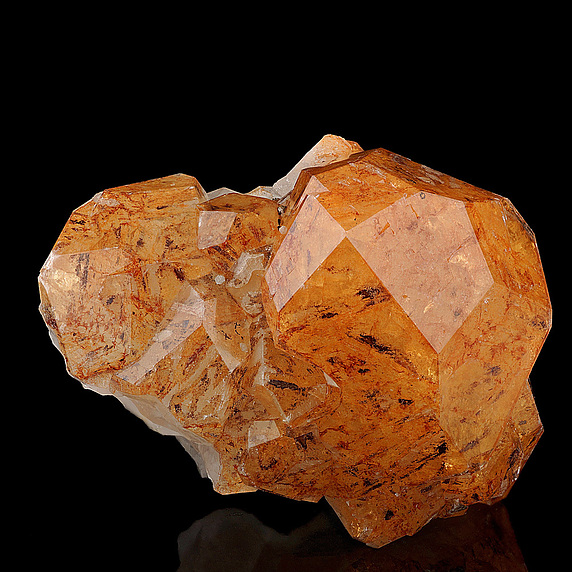
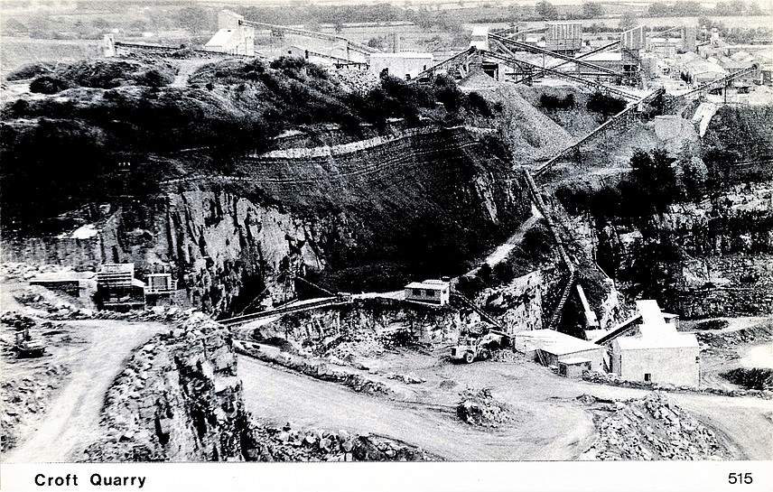


Croft and Huncote Quarry, Croft, Blaby, Leicestershire, England, UK