Minerals of King County, Washington
Last Updated: 15th Aug 2020By Eric He
Introduction
By far, many collectors have known the excellent minerals of King County, Washington. Whether it’s the pyrite from the Spruce claim or the scepters from Denny Mountain, these specimens have often been favorites in collections all over the world.
However, many important mineral occurrences in the area have yet to be noticed by all but the most meticulous collectors. Ranging from stunning calcite blades associated with pseudomorphs from the Cadman quarry to world-class realgar crystals in the Green River Gorge, King County provides a wealth of minerals.
The Lowlands
When one thinks about King County, or Washington for that matter, the Cascade Mountains immediately come to mind. However, several significant mineral deposits with specimen potential lie well within the lowlands of King County.
If you look at a satellite image of the greater Seattle area, you can immediately notice a white blotch just south of the city of Monroe: a large quarry. The Cadman quarry has been running for fifty years, and for good reason. They are the largest building materials and cement supplier in the area. The quarry has also been a long-time favorite for rockhounds due to its unique minerals.
Cadman is situated within the basalt and andesite of Mt. Persis, which covers a large portion of the lowlands. Minerals occur seemingly in a hydrothermal “drip” environment. One of the most common minerals at Cadman is calcite. Calcite forms in interesting inverse rhombohedrons that range from under an inch to over 4 inches in diameter. As the deposit is quite deep within the quarry, often pieces with no damage and razor-sharp edges can be extracted, posing a hazard to collectors.
Another mineral that occurs at the Cadman quarry is quartz. Quartz can be found in the form of blue agate in veins many inches thick, as well as druzy inside of pockets. Quartz is commonly light amethyst. Finally, we consider the most interesting mineral formation-strange pseudomorphs of quartz and calcite after prismatic aragonite. These fuzzy sticks range from an inch all the way to three feet, and often they are found with complex growth resembling artichokes. Sometimes, pseudomorphs can have calcite blades perched on top.
If one is to travel ten miles to the east, there they would find the Cedar Ponds quartz deposit. Although it isn’t as rich as most King County quartz deposits, nevertheless it holds a spot in this article. Quartz here takes some interesting forms – both normal and reverse scepters are found, many crystals are amethystine, hoppered crystals are common, and rare Muzo-habit quartz crystals are also found here. The deposit is in an andesitic breccia in the volcanic rocks of Mt. Persis. Commonly, collectors sift through the material at the base of the cliff to find crystals, but those crystals have fallen from the cliffs above. Rappelling from the top has yielded monster Muzo-habit quartz scepters to 8 inches!
Down south, we have the Green River running through the Ravensdale and Black Diamond area. It runs through a narrow gorge in parts. In a certain portion of the gorge lies the Royal Reward deposit, which for a long time held the world’s best crystals of realgar in a calcite vein.
The Snoqualmie River Drainage
In King County, the primary river draining the Cascades is the Snoqualmie River. This river runs from the Puget Sound all the way up to the crest of the Cascade Range, splitting into three forks at the city of North Bend: the North, Middle, and South forks.
The North Fork
Unlike the other two forks, the North Fork runs parallel to the mountains, staying in the foothills for around 20 miles before it swerves east into the mountains. This fork of the river is accessible via a county road, that turns into a Forest Service road later on. The area around the headwaters of the North Fork have immense potential for mineral specimens.
Serious collectors have always enjoyed finding Japan-law twins at Devils Canyon, a narrow gulch. In Bart Cannon’s Minerals of Washington, he describes a deposit very close by known as “Foxy’s Ledge” that apparently held giant scheelite crystals to over an inch wide. However, recent efforts to find this deposit have been unsuccessful.
However, Devil’s Canyon is far from being the only mineral deposit in the area. The Apex mine, as described in the 1990 Metal Mines of Washington Preliminary Report (Derkey et al.), produced chalcopyrite, galena, sphalerite, tetrahedrite, and stibnite in a quartz vein 2-6 feet wide, as well as gangue minerals pyrite, arsenopyrite, arsenolite, quartz, tourmaline, and calcite. The mineral richness and variety indicates that the vein may not be completely filled and may have vugs, and recent work by collectors have exposed vugs with quartz crystals as well as interesting calcite structures.
The surrounding hills, especially those around Prospectors Ridge, are the homes of many old workings. Due to the long trip required on the county road or the high-clearance road on Money Creek, this area has remained relatively unexplored.
The Middle Fork
The Middle Fork of the Snoqualmie River runs straight through the somewhat newly-established Alpine Lakes Wilderness. From North Bend, it travels straight between I-90 and US-2, making it quite remote. Access is via a single road, the Middle Fork Road. The road was recently paved until the Taylor River. The road then takes a turn along with the river and then becomes a progressively worse gravel road until the trailhead at Dingford Creek, 17.4 miles in, where stands a gate. In 2007, the Forest Service decided to close off the rest of the 10 miles of road due to high maintenance costs and the lack of funding. However, claim and property owners that are affected by this closure get an access key to the gate and may still drive in.
The earliest explorations in the Middle Fork area was in the early 1900s, when deposits of copper were discovered high in the Middle Fork valley. Claims were staked, holes were drilled, and a few adits(tunnels) were made. It was only until the latter half of the century that collectors became aware of the specimen potential of the area. The now world-famous Spruce claim was first commercially mined for specimens in the 1970s.
A quick run-down of the claimed deposits in the area give two patented claims, namely Spruce and Pedro. Pedro is the biggest breccia pipe in the area and has produced dinner-plate sized masses of iridescent chalcopyrite crystals on quartz matrix, as well as pyrite cubes up to four inches, but was only seriously worked for a decade or so, never gaining as much fame as Spruce. Pedro is now dormant, but in June 2019 rumors that operations may begin again have surfaced.
The unpatented claims in the area show much more variety of minerals. Take, for example, the Purple Hope #4 claim on the Green Ridge deposit. Joe George has been working this claim for almost two decades now, and the claim has produced some very aesthetic (and large!) amethyst scepter groups, as well as rare Reichenstein-Grieserntal quartz twins. The pockets at his claim get to an astronomical 40 feet! Green Ridge was covered by an article in the 2015 Rocks and Minerals periodical.

A cluster of glassy quartz crystals with a few crazy-lustrous amethyst scepters on a matrix of well-crystallized mica from Green Ridge.
Much more interesting minerals occur further up the Middle Fork valley. Just across the valley from Spruce is the Puffball claim, a relative newcomer in mineral specimen production. However, as mining ramps up, the amount of minerals and their quality goes higher and higher. Large octahedral pyrites occur with a unique suite of carbonates including aragonite(!) and siderite. Two scheelite crystals have also been recovered, one being on matrix.
If one is to head to the southwest from Puffball, one runs across the Condor (Pegasus) deposit. This deposit is pretty well-known in the area for spectacular chlorite- and actinolite-included quartz crystals. In the upper reaches of the deposit, which requires using rope, siderite rosettes as well as very interesting lightly amethystine reverse scepters may be found. In the upper part, the inclusions are less dominant, but some scepter heads have both fluid and what appears to be anhydrite included inside.
If one slides down the mountain up at Condor and goes downstream, they will find the Shangri-La (Porter) claim. The deposit is located in a narrow gulch that runs down the ridge. The mineralogy at the claim is extremely simple there, constituting of nearly completely quartz. Up the valley, but on the north side of the Middle Fork lies the Clipper deposit. Clipper is hard to access, it lies at a slightly higher elevation than the Spruce claim. Clipper is not as well known as the other claims, but it deserves a spot nevertheless. Clipper’s mineralogy is much simpler than the other claims discussed, it essentially produces only oxidized siderite and quartz crystals, sometimes forming scepters and Japan-law twins. If one continues up the valley, on the north side one will run across in order the following localities: the Big Chief claim (large quartz, some pyrite), the Katie Belle claim (small clear quartz scepters, calcite, barite, pyrite), and finally the last mineral occurrence of note is the Dutch Miller Mine, in which only one small find was made by Bart Cannon in the 1970s of sphalerite on siderite.
The North Bend Area
As the three forks of the Snoqualmie River diverge exactly at the city of North Bend, I did not put the localities nearby under either of the three forks. These localities are accessed through the Campbell Global tree farm, which requires you purchase an access permit to enter their property. If one wants to drive in, one must obtain a motorized access permit.
If one is to look at the city of North Bend, the first thing they might notice may be Mt. Si, a 4000-foot forested mountain towering over the small buildings. Mt. Si is a very popular hiking destination in Washington, and thousands tackle it every year for the magnificent views of the Greater Seattle area and the Cascades at the summit. But little do most of these hikers know, just a thousand feet from the summit of Mt. Si lays the Bald Hornet quartz crystal deposit.
The Bald Hornet claim is a small face in the middle of the woods between Mt. Si and Mt. Teneriffe. It produces small, but clear and lustrous quartz. But what makes this locality worth mentioning is that Japan-law twins are very common here, and that the rare type of tourmaline called Luinaite makes common appearances here. Specimens with both Japan-law twins and “sprays” of luinaite are highly sought after among local collectors.
Continuing to the east, we come upon Mt. Teneriffe, a similar hike to Mt. Si but much less traveled and appreciated. If one travels down the other side to the north, they will find a small cave, with breccia exposed. The quartz crystals here average a lot larger than the Bald Hornet, and as with the Bald Hornet, Japan-law twins are relatively common. Even a few Reichenstein-Grieserntal twins have been extracted from the deposit. Twins can range from 1/2″ each ‘ear’ to 4″.
If one follows the ridge to the northeast, one arrives at Bessemer Mountain. On this mountain, there is a skarn deposit exposed along an old and abandoned logging road. The skarn produces large rough andradite garnet crystals as well as very interesting needle-quartz coated pseudomorphs. The pseudomorphs are of hematite after an unknown mineral, perhaps epidote or a pyroxene.
Another popular hiking destination in the area is Mailbox Peak, located between the Middle and South Forks. This peak is rich with breccias, with one in particular being mentioned in literature. The Horseshoe Mine breccia contains small vugs with lots of needle quartz, often they can be found as doubly terminated crystals loose in their pockets. Euhedral pyrite and chalcopyrite crystals can also be found in the mine workings.
The South Fork
The South Fork is followed closely by the Interstate 90 Sound to Mountains Greenway, giving the area much easier access than the other two forks of the Snoqualmie River. Furthermore, numerous small closed logging roads function as trails. Surprisingly, this area has not been explored to even close to the extent as the Middle Fork.
Coming in from the west, after one passes the foothills of the Cascades, one can see a towering spire on the south side of the freeway. This is McClellan Butte. According to older reports, miarolitic cavities with light smoky quartz and albite feldspar can be found in the area. Bart Cannon described it in his Minerals of Washington.
The north side of I-90 remains relatively unexplored in the South Fork region, which is a stark contrast to the next locality: the famous Hansen Creek.
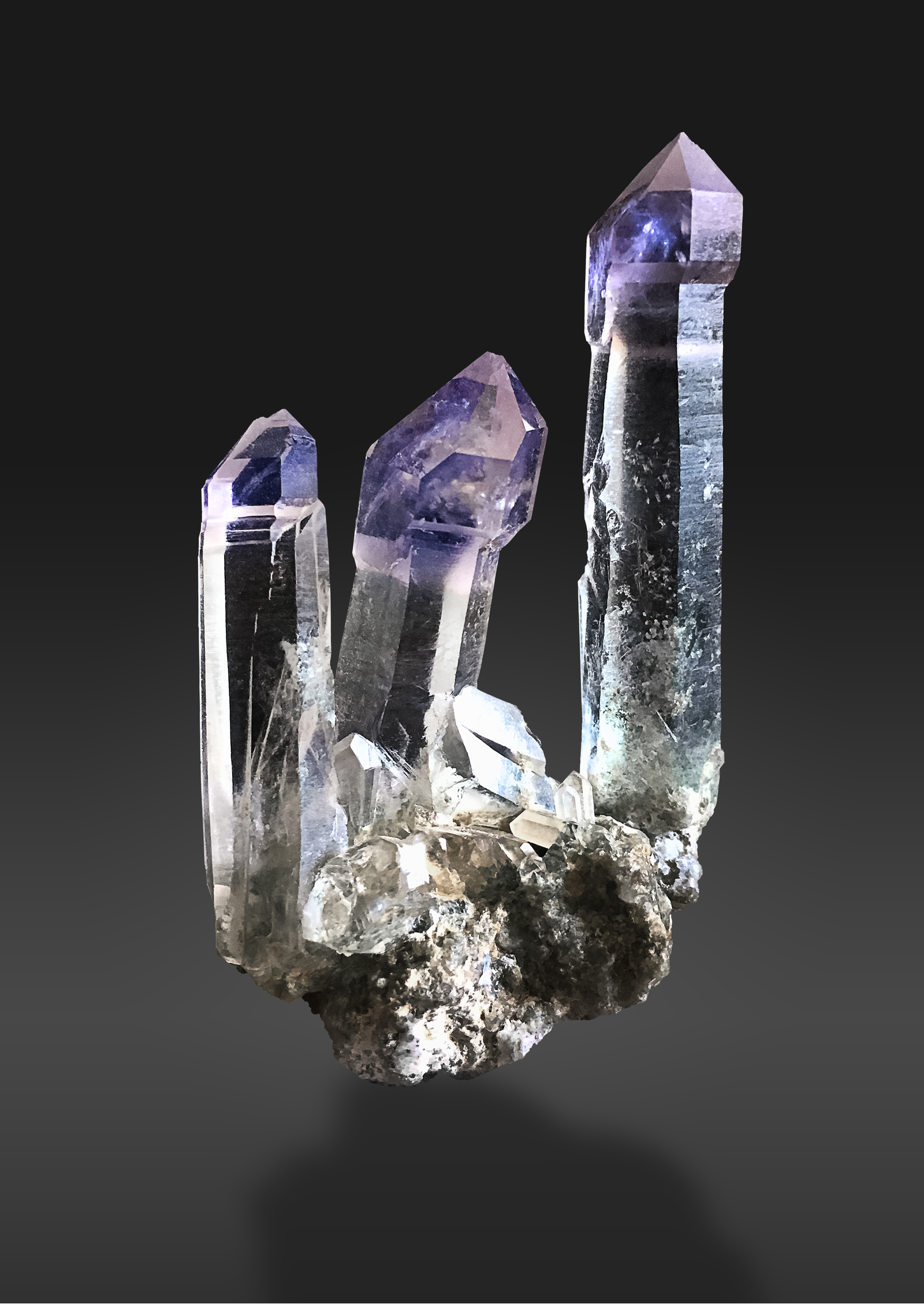
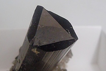
Hansen Creek can be thought of four separate outcrops of the same breccia body. On the forested north face of Humpback Mountain lies the Garden Slug deposit, which includes both the claim itself and the slide zone underneath; if one is to flip around the mountain to the west side, they will find the Banana Slug deposit; and further up, following the creek, is the roadcut deposit; and finally way up top is the Butterfly deposit. Each deposit holds unique minerals and formations. The Garden Slug is by far the most well-known, it is easy to access and features the largest amethyst scepters of all four deposits, some reaching up to 7″ long. Crystals feature actinolite, chlorite, pyrite, siderite, fluid, and hematite inclusions. Euhedral siderite can also be found. A mysterious white mineral has also been found both on matrix with quartz as well as included inside quartz, believed to be an apatite. Doubly-terminated and healed crystals are common, as well as complex growths. Complex amethyst scepters known as “spaceships” are highly desirable, especially among collectors who frequent the area.
An excellent amethyst scepter from the Garden Slug deposit.
The Banana Slug deposit is not mentioned in literature and thus remains elusive. However, it has produced very nice clusters of smoky-amethyst scepters in the past. The next deposit is very unique, in that the quartz crystals found are small, rarely over 1cm, and that a large suite of other minerals may be found, which includes pyrite (sometimes in a “flattened” or “domino” form); the titanium minerals rutile, anatase, and brookite; and well-crystallized prisms of fluorapatite. The titanium minerals are found encased in calcite at the westernmost end of the roadcut. If one continues further up the road, park at the gate and continue up and around a mountain, one finds the Butterfly deposit. In the past, the Butterfly zone produced great Japan-law twins to five inches as well as pyrite-phantomed quartz. However, the amount of recent working of the top section of the deposit has unfortunately caused the more productive bottom section to be buried under rubble. Now, significant excavation must be done in order to expose the best part of the deposit.
Nearby to the east, lies the Silver Peak deposit, which holds anatase and small quartz crystals. It was first found and described by the Mountaineers of Seattle. The deposit is located in hard rock on the north side of the peak.
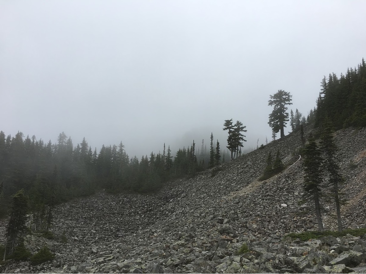
On the way up to the Silver Peak deposit. Views were less than ideal that day.
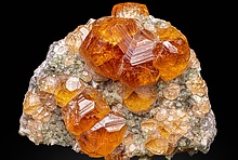
Many of you have waited a long time for this locality-last, but definitely not least, Denny Mountain. The occurrence of amethystine scepters in a narrow gulch on the western side of Denny Mountain was first discovered by Bill “Willie” Hawes in the early 60s. The initial finds were made in clay pockets high up in the gulch, with lots of crystals loose in pocket clay due to weathering. Since then, collectors frequented the area, until in the 1980s, Bob Jackson claimed the deposit and began working it with power tools and explosives. A small cabin was helicoptered in to the top of the mountain. Pockets were hit that yielded hundreds of pounds of crystals, both giant raspberry scepter clusters to two feet by two feet as well as Japan-law twins reaching a foot across were recovered.
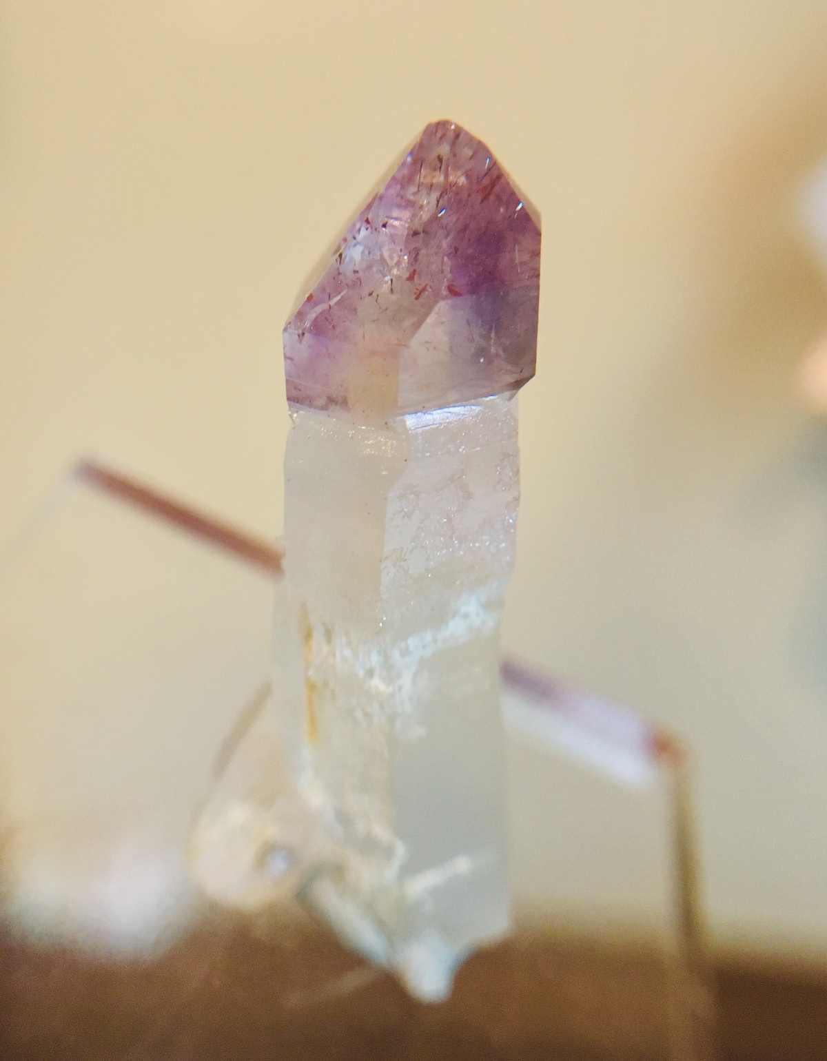
A classic "raspberry" sceptered quartz crystal from Denny.
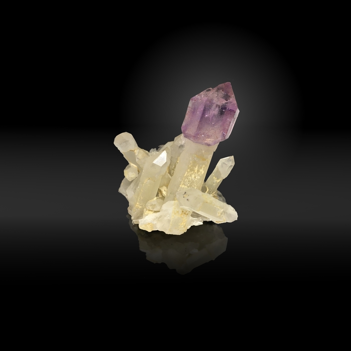
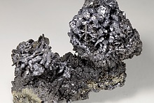
A "raspberry" quartz scepter on matrix.
Operations at Denny ceased in 1990, when the claim lapsed. There were no new commercial operations past that point.
Now, dozens of collectors a year seek out raspberry scepters and other skarn minerals in the highest reaches of the 3000-foot canyon. The deposit is a skarn, formed when the Snoqualmie Batholith intruded Triassic metasedimentary rock. The skarn is exposed in a narrow canyon that winds up the side of the mountain. Common minerals found include grossular, adaluria, epidote, hematite (in its specular form), quartz, and calcite. As one ventures up the canyon, one finds first the typical suite of skarn minerals, but quartz becomes more and more dominant with elevation. At the highest reaches of the canyon in a zone called the Vulture, tiny Japan-law twins are found as well as (occasionally) scheelite.
Denny has been worked frequently by amateurs recently, and although neat specimens have been found, no significant pockets have been struck. But maybe we are on the brink of a major discovery. Perhaps you might see a new raspberry scepter in your collection soon.
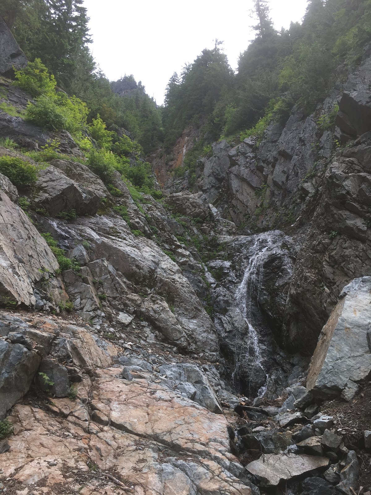
A view up the Denny gulch - the quartz and scepter zones are right around the corner!
NOTE-AS OF 10/25/2019, SOME PHOTOS STILL NEED TO BE ADDED.
Article has been viewed at least 25340 times.


Discuss this Article


