by Jolyon Ralph
2018 was a significant year for changes on mindat.org. Some you could not have missed, others are not so obvious, so I'll try to run through what we have done over the last year to improve the site.
The new look
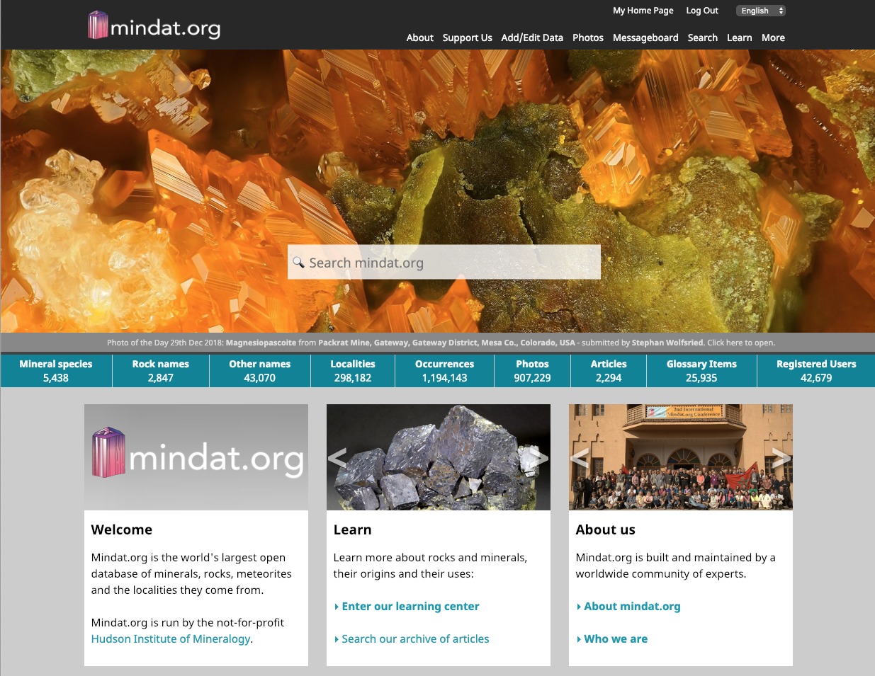
The most obvious change this year was to switch to the new home page design - the most significant change to the design since mindat.org was launched. Why did we do this? Let's look back at how the site design has developed. Do you remember which of these homepages greeted you the first time you used mindat.org?
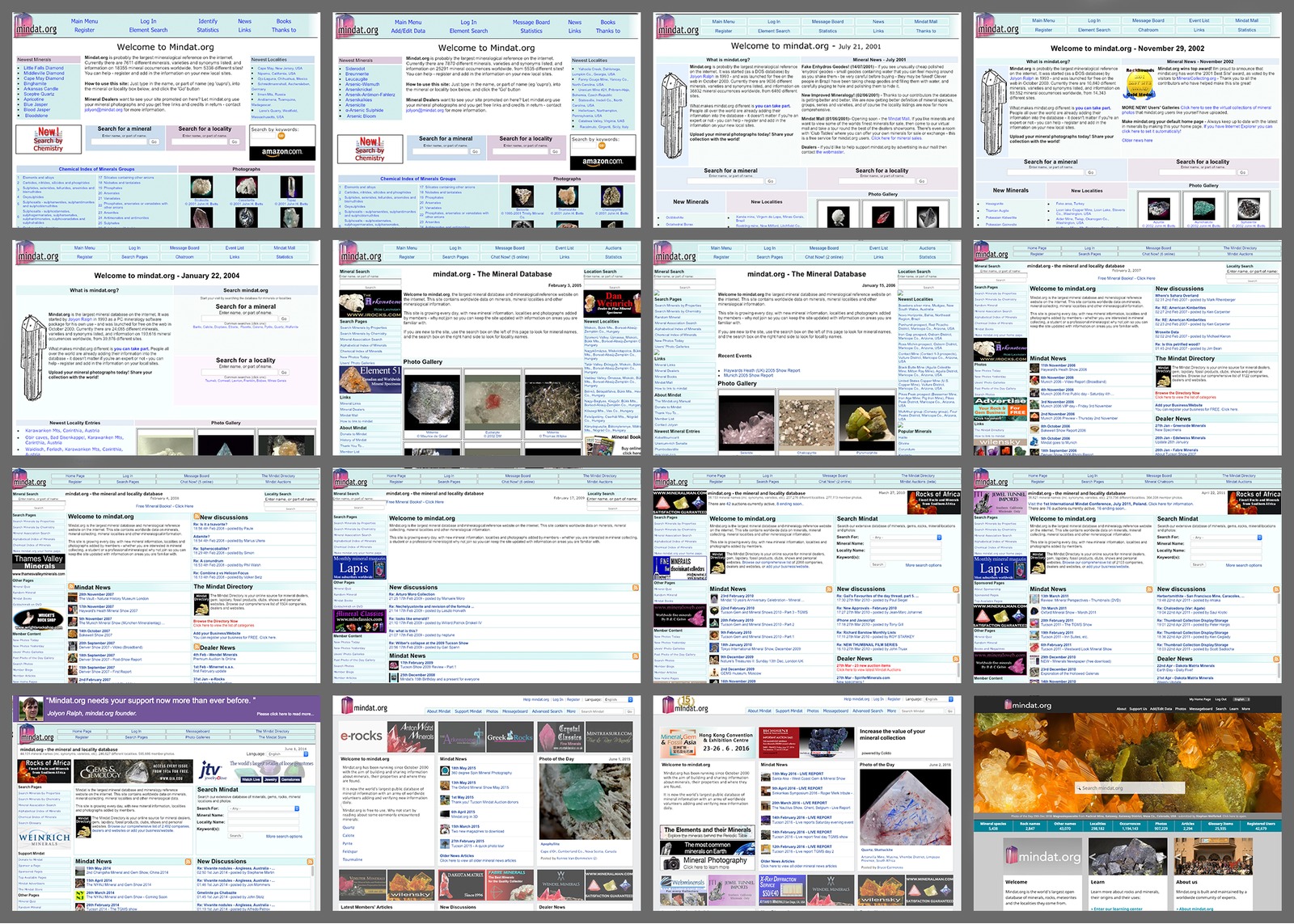
The mindat.org homepage over time
The reason we changed the homepage was that it became busy, it was a mess of boxes of lists of things which didn't mean much if anything to new visitors to the site. A decision was made that we needed to have three things prominent on the home page.
1. Who we are, what we do, and what information we have
2. A very prominent search
3. Expanding the photo-of-the-day so that it becomes a key part of the site design, changing every day.
The new design was built in answer to this, and although we've had some minor changes and updates since I think it has been successful. Do expect more changes in 2019, but probably not anything so drastic!
New Font
One minor change that may have escaped you is that we're now using a different font. It took a long time to choose the right font, and we had very specific requirements for readability, support for international character sets and, in particular, the ability to easily distinguish the capital I from a lower-case l (L) and number 1. This is very important when you consider that the mineral names lanthanite and Ianthinite are very confusing if you don't know whether the first letter is capitalized or not. Fortunately the new font makes this a lot easier than before. For those interested, the font we have chosen is Noto Sans by Google.
Mining Companies
We have started to build a table of mining companies on mindat.org and to associate the mines, deposits and prospects in our database with them. This is useful for many reasons, whether it is to know who to approach for permission to visit a site or simply to better understand the economic mineralogy of an area.
Mining Companies can be searched from the 'More' menu, which leads to this page.
Here's an example of how a mining company page looks:

We have added details on 440 mining companies already, taking information from their websites and in many cases adding in new localities to mindat.org that were previously absent.
We are now offering the mining companies the opportunity to sponsor their mindat locality pages with the addition of their logo and a box-out on the right hand side of the page providing information about the site, the business, their corporate social responsibility programme and even embedded video. See an example below:

Or, click here to see the live page.
If you are involved in the mining business please contact jolyon@mindat.org to learn more about how you can help us and help your company at the same time.
11 Million Places of Interest
We currently have around 292,000 mineral localities on mindat.org - which is a huge number, but nowhere close to covering all known localities. In many cases we have specimen labels referring to a nearby town or village, and if that town or village isn't the one we've associated with the locality in mindat, it can be quite tricky to track down the possible source of your specimen.
Using the database from geonames.org we have added in 11 million place names with coordinates worldwide that allow us to significantly extend and improve our search. Take for example a search for the Cornish hill of 'Carn Marth'. Currently there are no matches in mindat.org's locality database, but now when doing a standard mindat.org search we have the following at the bottom:

Clicking on the Carn Marth (not on the image above, on the real search page) leads to this page which shows details about the point of interest, the nearest mindat mineral localities and an aggregated mineral list of the nearest 10 localities within 10km to give an idea of the mineralogy of the place. In effect, these become 'mini-locality pages' in their own right - and we now have 11 million of these pages. Some of the places, such as television towers or hotels, may not seem important - but remember in some more sparsely populated areas these landmarks can be extremely important geographical pointers, and being able to search on such items and find localities nearby is very handy indeed!
It's worth mentioning that a significant amount of work was done not just in integrating this but in making it work fast enough - I did not want to add this to mindat.org if it was going to severely impact on performance. But, as you can see, it's very fast.
We have also used this data to add the 'Nearest Settlements' section onto mindat locality pages, this looks like this:

For region pages we now have a similar option to list the largest settlements within the region.
Locality Types
A new addition this year, and long overdue, is a way to record the type of locality that a locality page represents. Does the entry Shakhta Kazakhstanskaya refer to a town, a region, a mountain or a mine? (it's a coal mine in Kazakhstan, actually). Now we can record this information about a locality, and in many cases this is very important because there may be different political subdivisions with the same or similar name. By clicking on the (i) icon next to a locality name on a locality page you can get information about each of the levels in the name. In the example below the locality is in the Municipality of Bad Dürkheim which itself is part of the larger District of Bad Dürkheim. Understanding which level represents what type of locality is important for assuring localities and their associated minerals are assigned correctly.

We currently have several hundred types of localities listed divided into categories such as 'Mines and Prospects', 'Geographical Features', and 'Political/Administrative Divisions'.
Improving Locality Hierarchies
Many of our locality names came from obscure references, from mineral labels and from collectors' personal notes. Different people record locality names in different ways with no consistency. Localities within 1km of each other may have been recorded in entirely different ways. Sometimes localities are listed within political regions that no longer exist.
As a move towards standardizing this and removing such inconsistencies we have done a considerable amount of work this year to clean up the locality hierarchies (at least to some extent) of a number of countries. The UK, Russia, China, Japan, Sweden, Finland, Poland, Kazakhstan and the Democratic Republic of the Congo are amongst those that have had some significant changes this year.
Here's an example of how Japan's sublocality hierarchy used to look. Note a mess of provinces, regions, prefectures and other items all mixed together.
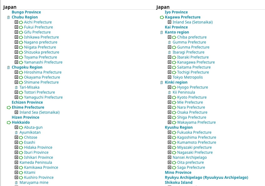
And now, here it is after we reorganized it based on current political regions.

Note that these correspond to the prefecture levels, and clicking on the [+] expands that hierarchy to reveal the associated subregions. We haven't tidied up all those subregions yet, that's still a work-in-progress.
We also haven't included the word 'Prefecture' on the end of each name because now that we can define the type of entry and list it on the page we don't have to put it in the name itself, meaning that locality names can be shorter - very useful for your labelling!
Foreign Language Locality Names
We have for a very long time allowed people to add in the 'locality name in the local language(s)' field when editing localities. This wasn't always very consistently used and if the region that a locality was in changed the chances were this field never got updated. It also didn't solve the problem of people wanting to search mindat in their own language, when that language isn't English and isn't the native language of the country involved. Imagine you're in Russia and you're searching for localities in Namibia. Unless you know English you're much more comfortable searching for Намибия than the English name. So, we need the ability to add any locality name in any language. We also want to add it in one level at a time, so Tsumeb, Oshikoto Region, Namibia in Russian combines the Russian names for Tsumeb with the Russian names for the Oshikoto Region and Namibia automatically (Цумеб, Ошикото, Намибия, if you're interested.)
Work on this has only just begun, with the vast majority of localities untranslated, but over time this will build up into a powerful tool. At the moment search doesn't work with these fields, but that will come in early 2019.
As you can imagine entering in all different language variants for a locality name is quite time consuming - so I've added in a tool to make it easier by taking the translations of locality names from the appropriate Wikipedia page (if it exists) - so all the different language versions (at least those used by Wikipedia) are included. This has the advantage of almost always included the most important language variants for that particular region.
Improved Search
We have improved the searching on mindat.org this year with new search options, some are minor improvements on existing pages and others brand new:
For locality searching, we now have an Advanced Locality Search option (under the Search Menu)
Click here to test it
As I mentioned above, we're going to be spending a lot of time in 2019 improving search. Making it faster and giving more control over finding exactly what you want within our database.
Locality Page Changes
We changed the locality pages layouts this year, adding new information including a new section for a timeline of activity within a mine/deposit. We can now record a table of activities such as when the deposit was discovered, when mining started, etc. Eventually this will grow into a timeline that will allow us to do comparative analysis of nearby mines and possibly even animations to show progress of mining activity in a region over time. It will also be a useful tool for searching, for example in the future you'll be able to search for any mines in Germany that produced Cobaltite before 1800.
Another change has been to our non-hierarchical regions to allow us to select a 'soft' border for certain regions such as mountain ranges and mining areas. This removes the hard black border that normally surrounds the region so that it is more obvious that the borders are approximate.
But, the major changes made in late 2018 were performance related - a significant rewrite of locality pages which took several weeks of work has managed to speed up page generation by 75%-90%. Previously large pages such as aggregating locality data for an entire continent weren't possible - every time we tried it the database server crashed. Now, these pages can work. They can still take a long time to generate because of the amount of content they contain, but they do work!
Here's the page for Europe. It still takes a long time to load, but this is mostly due to the size of the page that is being sent to your web browser, not the work the database needs to do.
Quick Navigation
One thing you may not have noticed unless your browser window is wide enough is that we now have a 'Quick Navigation' panel on the right hand side of the page on many pages. Here's an example:

If you use this a lot you may find it easier to go to the Device Settings option in the More menu and select 'Content Alignment: Left' to move page content to the left rather than the center, which gives more room for the navigation without needing your browser window to be so wide.
Actually, an even better example is this very page. The very last change to mindat.org in 2018, made today on the 31st December, was adding in quick navigation support on article pages. Now, if you use the H heading block in Mindat Markup Language when writing articles, you'll automatically get a quick navigation list.
Article Categories and Article Search
Whilst on the subject of articles, we now have the ability to categorize articles and a much improved article search system. See Search Articles in the Search menu.
Also, after spending some time in the wilderness following the homepage redesign, in late 2018 articles returned to the home page.
Editing Improvements and Tools
A lot of work is done by a large number of people to add/edit and review information on the site. Making sure these tools work properly, and making sure that we have the best tools to reduce needless effort and repetition is important in reducing, um, needless effort and repetition.
I have been spending approximately 20% of my time in adding and editing locality and mineral occurrence data. This is more than I have done for many years - a big reason for this is that if I am editing localities myself on a regular basis I get to know what could work better, things that can speed up my work will also speed up the work of others. I add improvements to the tools as I work and then everyone else who is adding information can benefit from it.
Tools that have been added over the last year include:
* Automatic detection of localities that may be in the incorrect political regions (because their coordinates do not lie within the defined boundary of the region) - allowing us to either move it to the correct political region or fix the coordinates if they are wrong.
* Reducing the size of large region boundary files if they are too large to work efficiently with the site.
* Reference history on locality editing, if the same reference is being used on multiple edits you are doing, you can click on an item in your reference history to automatically add it to the locality list for the page you are editing to save needless copy/pasting.
Google Grant
Another of the 'work that was needed to make things stay the same' jobs this year involved applying for, and implementing, Google Maps grant for non-profits, which allows us to use unlimited Google Maps on our site. We had increasingly got to the point where our maps stopped working at some points during the day coming up with messages saying the map could not load. Getting approved by Google proved to be a complex and bureaucratic process - but we achieved it and the maps are now working perfectly!
Security Updates
Keeping the site secure is one of the most important tasks we have, so one of the more annoying changes this year was when many of you found you had to reset your passwords. The reason for this was that some of the older passwords were stored using a type of hash (one way encryption) system that has proven to be insecure. We had no way to know whether these insecure hashes had ever been stolen from us - we think almost certainly not, but we wanted to be absolutely sure we are safe. So as a precaution we forced people who had potentially insecure passwords to reset them. Sorry about this, but security is important!
Geohash
A small but useful change added to localities with coordinates this year has been the addition of a GeoHash value. A geohash is a unique code that combines the latitude and longitude into a short string, for example:
G#: 9mys21xxh is the Red Cloud Mine.
If you wanted to store latitude & longitude securely on a mineral label, for example, the geohash is a compact way to do it. Geohash is clever because if you reduce the length of the string, eg to 9mys21xx or 9mys21, you are pointing approximately at the same area but with a greater margin of error depending on the number of digits you drop.
You can learn more about Geohash on the Wikipedia page.
Out and about in 2018
This hasn't been a great year for travel compared to the past, but we did make some international appearances. It's important to note that currently only two events that I attend are paid for out of Hudson funds - the Tucson Show and the Munich Show (although the Munich Show is a relatively inexpensive trip for me, and at the Tucson Show we always raise more money than our costs). All other trips either are paid for out of my own pocket or funded through support from an event promoter, etc.
Tucson was a great success in 2018, in no small part due to Erin Delventhal's incredible work, including running the auction. In 2019 Erin won't be able to help us at Tucson so we're going to have to figure out how to try to do it all without her again. That's going to be tough. If you're at Tucson and can spare a few hours to help us collect donations for the auction, please get in touch!

The Tucson 2018 Auction
See the Tucson 2018 reports here.
We also participated in the 4D Workshop on Deep-Time Data Driven Discovery https://hazen.carnegiescience.edu/4d-workshop-june-2018 as part of our continued program of scientific work where our database is being used to help predict new discoveries in the mineral world and beyond.
Several mindat.org managers and supporters were also present at the 22nd meeting of the International Mineralogical Association, in Melbourne, Australia see here, although I was not able to attend myself.
Fundraising
As we mentioned before, this year was a crunch year for raising money to survive, and I announced in the summer that we'd need to raise $75,000 to continue to operate this year. It was an almost impossible task, but on December 28th we finally crossed the target and we reached our goal. I want to thank every single one of you who donated this year. Whether you sponsored a page, mailed us a cheque, gave us a mineral to auction or raised your hand to donate at events such as the Dallas Symposium, your support literally means everything to us. We are here, we're going into 2019 stronger than we went into 2018, and we're excited for the future.
Of course, just because the fundraising banner isn't on the home page any more doesn't mean we don't need your donations. We have a whole new year of expenses ahead of us, and we're going to need your support in 2019 and subsequent years to keep mindat.org alive. So, please Donate here.
Into 2019
So, what do we have planned for 2019? Our first job is to improve search performance and make search provide better results. Part of this will be to give you more control over how the search works.
We want to improve the maps on locality and mineral pages. Right now with large numbers of localities shown the results are somewhat messy.
We want to rewrite the photo upload system to make it easier to use and to make it possible to upload photos directly from a cellphone. Modern cellphones can take excellent photos - especially useful for locality photos when you can upload a new photo from your phone while you're standing at the locality.
We want to improve our information on active mines and mining companies and use this to build a stable source of sponsorship money into mindat.org to reduce the amount of times we have to ask you to donate.
We have lots of other ideas, and we want to hear your ideas too. There are things that would be nice to do, but they'll take a lot of time (and therefore money) to achieve. For example, a label printing system for the Mindat Catalogue, a new forum system or an iPhone/Android mindat app. For items like these we may give you the choice when you're donating money to allocate up to 50% of your money towards one of these optional projects - and once the funds for that specific project have been raised we'll start work on it! Some of these optional projects may be small, some large, but it will be down to you to decide by your donations which are the most important!
Have an idea for something we can do to improve mindat? Leave a message in the forum!
And a very happy new year from myself and the whole mindat.org management team!


Quick NavThe new lookNew FontMining Companies11 Million Places of InterestLocality TypesImproving Locality HierarchiesForeign Language Locality NamesImproved SearchLocality Page ChangesQuick NavigationArticle Categories and Article SearchEditing Improvements and ToolsGoogle GrantSecurity UpdatesGeohashOut and about in 2018FundraisingInto 2019


