Learning CenterWhat is a mineral?The most common minerals on earthInformation for EducatorsMindat ArticlesThe ElementsThe Rock H. Currier Digital LibraryGeologic Time
搜索矿物的性质搜索矿物的化学Advanced Locality Search随意显示任何一 种矿物Random Locality使用minID搜索邻近产地Search Articles搜索词汇表更多搜索选项
╳Discussions
💬 Home🔎 Search📅 LatestGroups
EducationOpen discussion area.Fakes & FraudsOpen discussion area.Field CollectingOpen discussion area.FossilsOpen discussion area.Gems and GemologyOpen discussion area.GeneralOpen discussion area.How to ContributeOpen discussion area.Identity HelpOpen discussion area.Improving Mindat.orgOpen discussion area.LocalitiesOpen discussion area.Lost and Stolen SpecimensOpen discussion area.MarketplaceOpen discussion area.MeteoritesOpen discussion area.Mindat ProductsOpen discussion area.Mineral ExchangesOpen discussion area.Mineral PhotographyOpen discussion area.Mineral ShowsOpen discussion area.Mineralogical ClassificationOpen discussion area.Mineralogy CourseOpen discussion area.MineralsOpen discussion area.Minerals and MuseumsOpen discussion area.PhotosOpen discussion area.Techniques for CollectorsOpen discussion area.The Rock H. Currier Digital LibraryOpen discussion area.UV MineralsOpen discussion area.Recent Images in Discussions


Identity HelpGeological deposits

12th May 2012 00:45 UTCAnonymous User
12th May 2012 02:00 UTCJeff Stella

12th May 2012 03:48 UTCNorman King 🌟 Expert
The photos are great! Thanks.
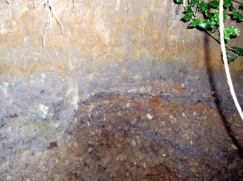
To me, the upper reddish brown, thick layer looks somewhat like till, but it is overwhelmingly clay with only scattered larger gravel clasts. It might be a lacustrine clay containing dropstones (dropped from the bottom of glacial ice as the ice melted at the contact with water) derived locally from volcanic or igneous dike materials. The bright red layer is hematite-rich clay. The hematite probably was washed down from the overlying, reddish brown lacustrine clay (if my idea is correct), concentrating there because it could not penetrate into less permeable bluish clay below. The bluish clay would be a weathered zone consisting of of pure clay (that you can probably roll up and tie in knots, like modelling clay--right?). Below that (bottom of the excavation) is the same reddish brown material containing possible dropstones as in the upper layer.
If my explanation is correct, the geological report you have would not seem to be incorrect.
This is all very interesting, IMHO!
Anybody else want to take a stab at it?
12th May 2012 04:21 UTCD Mike Reinke
What makes for the blue color? when the hematite leaches out all the way, clays are usually white, right? would the blue be of organic origin?
Heath, that is a striking color change, and nice photos, esp. the third one, thanks!
Jeff, i would pan that in a heartbeat too, curious about any heavy minerals in the pan...
12th May 2012 12:15 UTCAnonymous User
-------------------------------------------------------
> Heath,
>
> The photos are great! Thanks.
>
> To me, the upper reddish brown, thick layer looks
> somewhat like till, but it is overwhelmingly clay
> with only scattered larger gravel clasts. It might
> be a lacustrine clay containing dropstones
> (dropped from the bottom of glacial ice as the ice
> melted at the contact with water) derived locally
> from volcanic or igneous dike materials. The
> bright red layer is hematite-rich clay. The
> hematite probably was washed down from the
> overlying, reddish brown lacustrine clay (if my
> idea is correct), concentrating there because it
> could not penetrate into less permeable bluish
> clay below. The bluish clay would be a weathered
> zone consisting of of pure clay (that you can
> probably roll up and tie in knots, like modelling
> clay--right?). Below that (bottom of the
> excavation) is the same reddish brown material
> containing possible dropstones as in the upper
> layer.
>
> If my explanation is correct, the geological
> report you have would not seem to be incorrect.
>
> This is all very interesting, IMHO!
>
> Anybody else want to take a stab at it?
Thanks for that Norman we ( Me and the two local Geologists helping me with this work have not been able to find even the finest laminations in any of the layers, the bright blue clay is plastic but so is the red- brown above, and the red below the gravel bed The overlying and thickest deposits that cover the entier area ime working, is made up of a very dry, friable red brown loamy clay with minor pebbles, below that i usually find an at first blue sandy clay containing organic materal mostly what looks to be shiny very bright coal, this layer does change to a bland grayish coulor after being exposed for a while, this layer as well as the gravel bed must be related as ive excavated mammal bones that were tightly encased in both layers, ie half in the packed gravel the other in the packed clay above.
The area north of here( about 3 miles) is stated as once being the location of a large ice damed lake, this might give us the water to create these individual layers, ie slow melting and escape to the south, but does not explain the bone and organic material in the gravel bed, nor the basaltic andersite that lays to the north and south of its place of origin the almost straight line of the Cleveland dyke running in a south east north west direction.
The 3 new images show the gravel bed at 2 different locations and the related blue gray layer above, i have found mineralized bone and organic material incuding hazel shells and beech mast. The pic showing the bright veins in the lower red clay under the water line i believe is related to the same event that caused the bright layers at the location in the erlier post.
12th May 2012 12:24 UTCNorman King 🌟 Expert
The blue color is reduced iron. Iron in sedimentary deposits is well-known for ease of reversal in oxized and reduced states. I should not have referred to it as weathered. Altered, maybe, but not weathered.
Lake bottoms are prime places for reduction of iron. It would happen in stagnant conditions where organic matter also escapes oxidation due to inadequate circulation of water that has been in contact with the atmosphere. It is common for only the bottom sediment to be reduced (because, of course, that does not circulate), but the overlying water to be oxygen rich (because it can circulate). The reduced layer here is striking in the contrast and sharp contacts with overlying and underlying oxidized zones. I attribute that to poor permeability of the clay, but it is unusual.
I'd still like to hear alternative interpretations. In a case like this, two heads may be better than one.
12th May 2012 13:43 UTCNorman King 🌟 Expert
The lower conglomeratic zone in these photos suggest debris flow deposit to me, rather than alluvium. You might think about a catastrophic glacial lake outburst deposit, rather than slow melting--like the Glacial Lake Missoula flood in the States. There is information on-line about the kinds of deposits formed by such events.
The Gowganda Formation in northern Ontario Province, Canada is full of glacial dropstone deposits. You could look those up also. The texture is similar to that in your upper layer.
The two most recent photos (DSCF0371.001 and IMG_8115-001) don’t show such sharp contacts, and are more typical of contacts between oxidized and reduced zones in sedimentary strata that I have seen in the field (I’ll see if I can get some together to post, but I have a job to do today that will keep me away for several hours).

12th May 2012 14:17 UTCRalph S Bottrill 🌟 Manager
12th May 2012 19:46 UTCClaire Brimson
Great photos Heath! Are there any mines up with you? ones that I can go down into?
Claire
12th May 2012 20:53 UTCAnonymous User
ps anything you have i can use as a comparison would be most welcome as this is a big problem for me ie stuff i can trust!
The following images show a days work on my main excavation and shows me uncover a set of ribs burried in the layer above the gravel bed, ive found a lot of bone from this dig all from either the gravel bed or layer above, the layers above that are so far lifeless both in bone and stone fossils.
12th May 2012 21:01 UTCAnonymous User
ps anything you have i can use as a comparison would be most welcome as this is a big problem for me ie stuff i can trust!
The following images show a days work on my main excavation and shows me uncover a set of ribs burried in the layer above the gravel bed, ive found a lot of bone from this dig all from either the gravel bed or layer above, the layers above that are so far lifeless both in bone and stone fossils.
12th May 2012 21:15 UTCAnonymous User
12th May 2012 21:18 UTCAnonymous User
13th May 2012 00:55 UTCNorman King 🌟 Expert

My analogies are mostly from the Gowganda Formation of the Huronian Supergroup in Ontario, Canada. These photos are from near Elliot Lake, 10 or so km north of the north shore of Lake Huron. These beds were deposited about 2.35 billion years ago under glacial influences. Some are claimed to be tillites, others are laminated and were apparently glacial varves, and some are muddy sediments containing dropstones. These beds are all metamorphosed, and are now very hard argillites and quartzites. There are places where some of my group banged on them with a sedge hammer until their arms almost fell off, and they could not break off a sample (on the other hand, I just walked along and picked up pieces from the ditch–that’s the wisdom we get with age!).
One photo is of Upper Carboniferous (Pennsylvanian) beds in St. Louis, Missouri, and is not very glacial. It shows a portion of a cyclothem with an iron-oxide rich clay layer and bluish mudstone beneath it. Cyclothems were deposited during glacially controlled sea-level fluctuations resulting from variable amounts of former sea water locked up on land due to glacial advances and retreats in Gondwana, so there actually is a glacial connection, but that’s another story.
I’ll show that photo first. The red layer is clear. Ignore the strata above it, because it is nothing like your situation (it’s gray shale and then limestone with marine fossils). The claystone below it is largely yellowish and greenish gray just below the iron oxide layer, and is bluer below. Such bluish clay does occur here and there, but is not really common. Ralph Bottrill could be right about the vivianite, but I don’t think the clay in that zone could be pure enough montmorillonite for that to be the source of the color. I wouldn’t hang any interpretation on that color. The red layer isn’t very important, either–it’s a secondary (diagenetic) feature.
The photo below is the Gowganda Formation that shows muddy layers in the lower half with discontinuous thick lenses of gravel. The upper half is sand with continuous thin gravel layers. My interpretation is that this was a glacial outwash plain having scattered ponds (the mudstone) and crossed by streams (the sandstone), where there were occasional debris flows, some confined to channels (thick conglomerate lenses) and others spreading out over the plain (thin conglomerate beds). The presence of ponds and apparent debris flow deposits are similar to the situation you may be studying.

(Continued in my next posting.)
13th May 2012 01:18 UTCNorman King 🌟 Expert

The next photo is a larger view of mudstone containing scattered dropstones and an interbedded debris flow (where the hammer is).

This is the last photo. It shows gradation from coarse conglomerate deposited by very energetic mass movement (debris flow) at the base, upward to pebbly mudstone. Not shown here is the overlying layer of mudstone with scattered dropstones. That was in the next photo above.
This could be very similar to what you are working with in the Pleistocene deposits there. Possibly a glacially-dammed lake broke, with the initial torrent transporting the larger clasts. As the current diminished, there were fewer and smaller clasts, becoming more widely spaced in the mud. Bones might have been deposited then, except these are Precambrian deposits that predate multi-celled life. The overlying layers (see next photo above) show the usual quiet-water lake muds with dropstones–analogous to your overlying reddish clay with pebbles but no bones.

I hope this makes sense.
13th May 2012 04:16 UTCNorman King 🌟 Expert
I think your photos DV000269-001 and DV000291-001 are most similar to the Gowganda Formation analogs that I sent. Any two groups of photos of different formations in different parts of the world are going to be different. But the basics of these are quite similar, and considering that one set is Pleistocene and the other Precambrian, that's impressive!
13th May 2012 06:13 UTCRalph S Bottrill 🌟 Manager
13th May 2012 12:59 UTCAnonymous User
13th May 2012 13:31 UTCAnonymous User
-------------------------------------------------------
> This photo shows dropstones. I mentioned those in
> an earlier post. This is marine mudstone showing
> episodic deposition (thin bedding). The area was
> at least occasionally covered by glacial ice
> advancing from a near-by landmass. The ice
> contained pebbles and other sizes of lithic debris
> that fell onto the sea floor, the larger ones
> making little “craters” like you see here, as
> the ice melted underneath.
> Norman thanks for that ive got my head round most of it and its fascinating me, as i can see simmalaritys with my softer stuff, and it makes sence yet if ime to believe the explanations ive had from the people over here who have kindly tried to help me over here the deposits they say can not be pliectocene! becouse they say them deposits would have been bulldozed by the last devension ice flows?
But with all that said they can not yet give me an explanation of the laters ime excavating and what it contains, the area has been studied in the past but as far as i can see it was limited to sparadic bore holes and surface views in the deep beck valleys, ive tried to explain in my blog that the bore holes would have quite easily not picked up on the 3 to 400mm gravel bed and the thin bright coloured clay layers, and that a surface view of the beck valleys would indeed look like boulder clay as each individual layer would as i still observe it doing, fold into each other as each one gradually collapses.
These pics are of an outcrop i uncovered just to the south of my main excavation, we have aurgered this deposit it sits directly below the dry red brown loamy clay that covers this area, it apears to be alluvial in origin with occasional minor angular and sub angular and rounded pebbles along with intermittent specks of mica, jurassic fossils are also present in very good condition, i was informed by the geologists present that after a test with dilute HCL it indicated a high calcium carbonate content. this stuff is real tuff i was informed by the geologists this blue red clay along with the upper red brown clay this was the hardest clay deposits they had encountered.
Three more images in next post.
>
>
>
>
> The next photo is a larger view of mudstone
> containing scattered dropstones and an interbedded
> debris flow (where the hammer is).
>
>
>
>
>
> This is the last photo. It shows gradation from
> coarse conglomerate deposited by very energetic
> mass movement (debris flow) at the base, upward to
> pebbly mudstone. Not shown here is the overlying
> layer of mudstone with scattered dropstones. That
> was in the next photo above.
>
> This could be very similar to what you are working
> with in the Pleistocene deposits there. Possibly a
> glacially-dammed lake broke, with the initial
> torrent transporting the larger clasts. As the
> current diminished, there were fewer and smaller
> clasts, becoming more widely spaced in the mud.
> Bones might have been deposited then, except these
> are Precambrian deposits that predate multi-celled
> life. The overlying layers (see next photo above)
> show the usual quiet-water lake muds with
> dropstones–analogous to your overlying reddish
> clay with pebbles but no bones.
>
>
>
>
> I hope this makes sense.
13th May 2012 14:48 UTCNorman King 🌟 Expert
13th May 2012 16:19 UTCAnonymous User
PS these images are a follow on from my qoute to your earlier post Norman.
13th May 2012 19:55 UTCNorman King 🌟 Expert
As I suggested, there have been no more recent glaciations to remove the deposits you are digging. So don't try to make them part of an older interglacial. As we discussed, if so, those deposits would problably have been removed. The first thing somene will ask (and rightly so) is, "What evidence do you have for such a more recent glaciation?"
Then, you have only a few groups of bones, so talking about devastating the fauna and flora by climate change is going too far at this time. There is evidence for debris flows, some possibly catastrophic, adequate to explain the death of those animals and their transportation and burial at this site. I would stop there. Only after you have information from all over, concerning the whole fauna, and its characteristics over time, can you start talking about climate changes wiping out the fauna. And you would need to know from independent evidence that there were indeed climate changes, and what those were (e.g., colder, dryer, how quick, etc.).
There is a principle we talk about in geology--that of "Simplicity." It means that if you have evidence for a mechanism that can account for what you have found, don't offer some other speculative explanation that you favor for a reason not directly tied to what you have seen right there in your own data and observations, or in data and observations reported by other workers in verified ("peer reviewed") reports. The latter might include sedimentologic studies, published faunal lists, and taphonomic analysis of bone beds. (Taphonomy is the study of how the fossilized creatures died, how they got to where they were buried, and the processes of burial.)
You don't become a scientist by how much you know. You become a scientist by how you approach problems.
13th May 2012 21:31 UTCAnonymous User

13th May 2012 23:01 UTCJolyon Ralph Founder
Jolyon

14th May 2012 00:30 UTCPaul Brandes 🌟 Manager
-------------------------------------------------------
> There is a principle we talk about in
> geology--that of "Simplicity." It means that if
> you have evidence for a mechanism that can account
> for what you have found, don't offer some other
> speculative explanation that you favor for a
> reason not directly tied to what you have seen
> right there in your own data and observations, or
> in data and observations reported by other workers
> in verified ("peer reviewed") reports.
Sounds to me like you're following Occam's Razor there Norman!!! :)-D
But just as Norman is saying Heath, don't make things harder on yourself by coming up with wild hypothesis' or speculations on what you are seeing in the field. Go with what your instinct is telling you and follow it until it can be proven incorrect otherwise. It will make understanding geologic principles so much easier to comprehend.
14th May 2012 01:33 UTCNorman King 🌟 Expert
Jolyon is right. As the glacial ice withdraws, it deposits end moraines and ground moraines, and the stream run-off deposits the outwash plain with its ponds and lakes, and the deposits formed in such places may contain Pleistocene fauna. If the ice really did withdraw from your area at about 12,000 or even 21,000 years ago, the fauna would indeed be Pleistocene. It is also true that some "pockets" of sediment from earlier glaciations may have survived here and there in sinkholes and other odd places, as you suggested, but that is probably not what you are dealing with. Also, not all glaciers cover the same areas, and somewhere there is left-over morainal or other sediment from a previous ice advance that escaped removal, so some Pleistocene faunas date from glaciations that are several hundred thousand years old (or older, but that does not seem to be your situation, either).
Paul: I try to stay clean-shaven. :-D
14th May 2012 21:25 UTCAnonymous User
16th May 2012 22:58 UTCAnonymous User
19th May 2012 22:38 UTCAnonymous User
20th May 2012 00:13 UTCNorman King 🌟 Expert
I don’t know the origin of that assemblage of things you show, but you have left some things out–namely the slabs of fossiliferous Paleozoic and Mesozoic rocks. Also, it seems to me that the items you show were selected to display. Any deposit may contain some noteworthy items, but if you have a pile of only the noteworthy items, then I can’t really say what you are dealing with. You need to show the routine items. But, yes, all of that material could have been carried there by ice, streams, and mass movement (such as debris flows). There is nothing in the deposits as a whole that is out of the ordinary.
20th May 2012 01:26 UTCBob Harman
20th May 2012 04:11 UTCNorman King 🌟 Expert
Bob reminded me about the bones. I can see portions of these kinds of bones (they are nearly all incomplete):
a deer or antelope mandible
a carpal or tarsal of a small grazing mammal (such as deer or antelope)
lumbar vertebra of a large grazing mammal (bison maybe)
atlas vertebra of a large mammal (it’s got a big hole in it--I think it's horse or cow/bison size)
a few femoral heads of heavy mammals (such as horse or rhino)
other femora
upper part of tibia of a heavy mammal (rhino or small elephant?)
The bones all have the characteristic patina of bones that aren’t very old. I can't see in the photo, but I'd bet they are quite porous. Dinosaur bones and other ancient reptiles, as well as very old mammalian bones, are usually more heavily mineralized, and white or cream colored. Sixty-five plus million years will do that (or even 20 or so million years).
20th May 2012 07:57 UTCBecky Coulson 🌟 Expert
I am not an expert in paleontology either...but you are right, these are mineralized bones (sub-fossils) from the pleistocene. During the last glacial period, a huge land bridge connected Britain and Europe (perhaps as recently as 8000 years ago) - it was savanna-like, and the species that Heath has found were common there. Identical sub-fossils are being dredged from the North Sea ("Doggerland" area) in large numbers by fishing trawlers,and they are commonly seen for sale (cheaply) at mineral/fossil shows. Earlier fossils are almost certainly those scraped away by the glaciers, and I don't see anything unusual in the pebbles.
Like Bob, I feel that Heath should be seeking the help and advice of local paleontologists, because his site is obviously one of scientific value and should be excavated properly. There are people in Newcastle (the Hancock Museum) or Durham University who would be interested.
Heath, the fossils from the North Sea are not stable, and need preservation - apparently, they begin to crumble over time. You have made a most excellent find, and should get full credit for your curiosity and work, but your site really should be reported to professionals.
Best wishes, Becky
20th May 2012 10:13 UTCJolyon Ralph Founder
20th May 2012 11:41 UTCBob Harman
20th May 2012 13:13 UTCAnonymous User
Bob ime in North east England and do indeed have permision from the land owners infact they are very keen to find out about the gravel beds ive descovered, i am in contact with Archaeologists and geologists both local and further afield, also if you view my blog at historyofabeck.blogspot.com you i hope will see i am conducting my excavations in as correct a manor as possible considering my limited resources ie i was unemployed for the first year of my work sometimes having to use half a spade and a screw driver to excavate, and a kids camera.
Norman sorry your right not enough info with the images! the mineralized bone ive managed to educate myself to what ide call a more than decent level ie they when dug directly from the gravel bed mostly caremel in colour and all heavy with the same greasy shine as the minerals rocks and fossils found, not one bone dug from the gravel beds shows signes of attention from human nore scavengers. the bones look to date late devensian - early holocene.
The large raidius u refered to ime quite sure is cervidae, i also have pieces curently being viewed by proffesionals, including a carved artifact, stone tool, and unknown mandible, they can all be viewed on the blog but as is the nature of blogs its a bit of a pain trawling through. i am more than happy to post any of my finds but do not whant to apeare rude ie overposting ! ;-)
Becky ive been there and had the t shirt as far as Durham university and local museums are concerned they are and i quote monertering the excavations via my blog, the county geology group are involved and we have augered parts of the area surrounding the excavations, so far finding that the layers that cover the gravel beds and there are at least 3 seperate levels are aluvial in nature.
Jolyon yes i think ime unlikly to find any Elephants ! ;-)Again thanks to all for there interest and input sorry for the lack of info sometimes but theres a lot of it and only so much space.
20th May 2012 13:27 UTCAnonymous User
20th May 2012 13:33 UTCAnonymous User
-------------------------------------------------------
> THANKS JOLYON !! I was not sure where Heath
> was blogging about as I did not go thru all his
> voluminous posts, never-the-less, there are
> various regulations about excavating vertebrate
> fossils (draconian in some areas!!) and human
> remains in the USA and, I am sure, many other
> countries as well. As I stated he should bring
> his find to the attention of local "official"
> experts. CHEERS..........BOB
Bob thanks for your input all is most welcome but if you viewed the begining of my blog it clearly states that i am studying the geology and fossils and mineralised bone found in it in the south west area of cleveland north east england ime sorry if you missed it.
20th May 2012 14:57 UTCBob Harman
20th May 2012 16:38 UTCNorman King 🌟 Expert
Do I understand correctly that you collected those slabs as loose clasts in the gavelly layer such as your daughter was digging, and in which the bones are?
20th May 2012 19:12 UTCAnonymous User
-------------------------------------------------------
> HEATH I agree with you that I should have read
> the beginning of your posts stating that you were
> doing your work in Northeast England. And I will
> take it at face value that all the folks with
> legal, property and paleontological interests in
> your work have been notified and are aware of all
> your diggings and excavations etc. I guess it
> is just that the trained amateurs and
> professionals that I know and have worked with
> just do some of their blogs, postings and pictures
> a bit differently than you have. I note that Becky
> C above seemed to agree with me. I will now
> step back and just observe this thread as it
Bob i hope you change your mind as all input is as ive said greatly needed and welcome, as for my blog there is also two seperate statements one basicaly saying ime not very good at this blog thing but please bare with me, the other that i use the blog as a record for myself, and sometimes just need to get something on there to record it, so your right its not the best but hopefully one day when i get to the bottom of what ive stumbled across ile sort it out.
> further develops; no more posts on this topic from
> me. Good luck.
> CHEERS.............BOB
20th May 2012 19:29 UTCAnonymous User
20th May 2012 19:52 UTCAnonymous User
20th May 2012 23:13 UTCNorman King 🌟 Expert
Wow! I’ve never seen a debris flow deposit like that! But don’t conclude anything rash from that statement. The material you are working was unquestionably deposited by a debris flow. Nothing else can deposit a sediment like that, and, at the same time, debris flows are quite up to the task.
I googled “glacial debris flow” and clicked on “images” for results. Lots of great photos of debris flow deposits, and they are usually associated with a story of some sort if you click on them. On the 3rd page of results I was surprised to find a photo that I uploaded to Mindat, photo no. 401791 (“Megaconglomerate in Gowganda Formation”).
Also on page 3 of results is another photo (at http://clasticdetritus.com/2009/09/18/friday-field-foto-93-permian-debris-flow-deposit-in-death-valley/) showing a “Permian debris flow deposit in Death Valley” and listing characteristics of such deposits. Then I found this video of a debris flow in progress, accessed at http://www.encyclopedia.com/video/k3W-wDIR-Os-debris-flow-event-25-december.aspx.
You gotta see that video. In so doing, you will see how a deposit such as yours forms, and why the bones you collected are so fragmental. The violence of the flow will be self-explanatory. If you were caught in such a flow, your remains would be in just as bad shape! And you will see why it is unlikely you can find bones in any better condition, or that what you find will be indicative of any particular setting.
One of the reasons we like to see professional work in excavating such deposits is that the matrix material will be carefully and systematically collected and examined, including sieving it back at the lab and examining the residue in each size grade under a binocular microscope to find other indications of what the ecosystem was like–looking for pieces of insects, worms, seeds, pollen, leaf fragments, rodent teeth and bones, lizard remains, fish scales–anything! Your deposit is not suited for that, however, because of its origin–it’s probably a mixture of a lot of things from several micro-environments, all jumbled together. I think people would look, however, but only to confirm that.
Quite a study you have, though. With the advice of experts, you should find out exactly what to do with it. I have worked with amateurs myself, and my experience has been generally favorable. With your interest level, you may find things that no professional would find, simply because they usually have other projects to take their time. I think you are doing well, and I congratulate you on your approach. I would be glad to look at anything else you wish to show.
21st May 2012 20:50 UTCAnonymous User
21st May 2012 22:09 UTCAnonymous User
-------------------------------------------------------
> Thanks for that Norman and your explanation makes
> sence to me but i would like to ask your opinion
> on something that puzzles me, from what i have
> studied and already new about this part of north
> east England, i believe there are two prime
> candidates for a flow like this one was about 3
> miles to the north an ice damed lake, and a valley
> area to the south east ( the esk valley) but as
> ive mentioned before these deposits both the
> gravel bed and almost stoneless seperate aluvial
> layers that cover it, ive found to be the same in
> thickness and make up both north and south of the
> natural barrier that is the Cleveland dyke, i
> would have thought the dyke would have had an
> influance on the nature of the layers either side
> of it? i hope you get what ime trying to say. also
the gravel bed like the layers above are very orderly
ie more or less the same thickness either side of the
dyke? and were i have evcavated into the layer abve the
gravel bed its shown it to be as flat as a snooker table
so to speak.?
> Again thanks for the help and i welcome any help
> or ideas any othe forum members have.
21st May 2012 22:53 UTCShelly St.Pierre
Hello Heath,
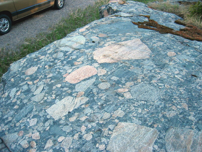
This is a great discussion! Just wanted to show you some of the Breccia we have in Northern Vermont. (New England, USA) I learned this from the brilliant minds here at mindat. The schist is mica, the cobbles are quartz.
Good Luck in your endeavor, this is a great place to learn, and nobody here laughed at me when I asked if it was kimberlite.:-)
Shelly
21st May 2012 23:20 UTCAnonymous User
21st May 2012 23:37 UTCAnonymous User
Any way heres the peice i found today i believe it may be a coral or sponge ive not seen before? the material its made of seems dark where it can be seen and maybee crystals are to be seen? it does bubble a bit with viniger? and its heavy.
22nd May 2012 00:51 UTCNorman King 🌟 Expert

We (Jolyon and I) have already answered the question of where the bones came from. They were washed out from a deposit left by the last melting glacier. Maybe you can ask the question in a different way for me to see why you are puzzled by this. The debris flow occurred after the last glacier retreated, and it eroded deposits left by the glacier or its meltwater streams, in which the bones were left–possibly by flooding from a glacial lake, but that isn’t necessarily the case.
Shelly,
Your question about kimberlite was excellent! In looking at your photo, I see that the deposit appears to include ultrabasic rock fragments. They’re grayish green. Compare them with this photo of kimberlite that I posted on Mindat.
Here are two additional photos of the kimberlite that I did not post (maybe I should!?)
In your photo, if the over-all rock is schist (I can’t quite tell from the photo), then it looks like a metamorphosed kimberlite. However, I would not expect to find a kimberlite in Vermont. Now, this is really advanced geology, but it turns out that kimberlites “erupt” in cratonic regions such as the Canadian Shield (my photos), not in orogenic belts such as the Appalachians. I am impressed that you saw the textural and apparent compostional similarities, nevertheless. You’re good. You could be a geologist!
22nd May 2012 20:34 UTCAnonymous User
Sorry if ime missing something.
As for the debrie flow what i was trying to say is if a flow hits an obstical as it would have ( the cleveland dyke) there would be a difference in the bed left behind on either side of the obstical yet ive found the gravel bed to be almost identical in depth and formation either side of the dyke.?
22nd May 2012 22:03 UTCBecky Coulson 🌟 Expert
22nd May 2012 22:34 UTCAnonymous User
Becky along with the help of others its great to have someone on board with a first hand knowlage of the area, ive not looked at your profile yet nore anyone else, but if your not far away i would be very happy to show you or any other interested members these deposits, believe me ime not looking for plaudits just answers .
22nd May 2012 22:55 UTCAnonymous User
23rd May 2012 09:00 UTCBecky Coulson 🌟 Expert
As for the Cleveland dyke acting as a barrier...I know its age, but do not know at what point it was partially exposed at the surface, so I don't know if it acted as a barrier during the Devensian or whether it was subsequently exposed by meltwaters (which were enormous), erosion, etc.
Thank you for the invitation - I would very much like to visit, perhaps later in the summer when our own work is winding down. (I'll contact you by PM sometime before.) I am most certainly NOT an expert in this field, but very much interested. In the meantime, I'll try to speak to a few people who are more competent (than me) in this area. The RIGS group should be able to access journal papers for you.
Heath, it is paramount that everything be labeled - date, exact locality, depth, horizon, etc. It doesn't matter if you cannot identify everything yet. Also, the sub-fossils need preservation!! Becky
23rd May 2012 16:56 UTCNorman King 🌟 Expert
I agree with the comments Becky made.
I know nothing about the dyke, such as its lithologic composition, orientation with respect to current and ancient (pre-glacial) terrain plus strike and dip, directions of ice movement, runoff, and debris flows, or anything else, so I cannot comment on it. There would be nothing wrong with your simply describing its relationships to other deposits in the area, discussing this with your contacts, and moving on. After all, you can’t do everything, especially all at once.
I suggest you write out what your objective(s) is/are, and then limit what you expend your energy on. In the mean time, if you record your findings somewhere, people will have that information, and maybe those who have the knowledge and expertise can use it in their studies some day. Right now you need to decide if you are doing paleontology or any of its subdisciplines such as paleoecology or taphonomy, or if you are doing geomorphology or any of its subdiscilines such as glaciology.
23rd May 2012 21:02 UTCAnonymous User
24th May 2012 01:00 UTCNorman King 🌟 Expert

I understand all the things you mentioned about trying to get someone’s attention. But I guess you do have a few people there who will help you out. Keep in touch with them. Learn all you can so you sound like you know what you’re talking about.
I can say that some of your questions interest me. I taught paleontology for 20 years, and have never heard them. To wit, your new question was about how the bones could have been tumbled about with boulders and not been scratched. Well, I can’t answer that, because I don’t know what happens to bones that are tumbled about with boulders. Maybe they don’t get scratched much. I’m sure someone has done experiments to determine that, but that’s not my specialty so I am not familiar with the literature. The video, in the URL I sent recently, showed very large, angular boulders–some must have weighed a ton–rolling along in the debris flow. But your photos show rounded boulders. They may have been in a stream and were rounded before being picked up in the debris flow. Maybe rounded boulders of relatively soft carbonate would not scratch bone.
I looked again at your photo DSCF1233-001, and made copies of two of the bones which I insert below. I can tell you for sure that these bones were fractured by intense force. They are broken near the strongest part of the bone–near the condyles. And only even greater forces could have broken them closer yet to the condyles. And they are not broken at the epiphyseal plate (that’s technical--for those of you who know bones!). These are unusual. Long bones tend to break near the middle, not near the condyles. Thus, I conclude that the forces in a debris flow involving boulders weighing many kg could have done this damage. That’s not very scientific, but it’s as good as I can do.

I don’t know about stone tools. I suggest you look through publications showing stone tools, and see what you have. If nothing like this is shown, I would guess it is not a stone tool. You need to show these to an archaeologist. Now, don't ask me how I woud explain this if it is not a tool. That's not my responsibility. It is your responsibility to demonstrate that it is a stone tool. I mention this and put it in these terms because it is important, and will help you gain credibility when talking to professionals. In other words, don't challenge them. The challenge is yours!
24th May 2012 22:31 UTCAnonymous User
As for the tool like ive said above ive shown all my finds to local proffesionals this piece i showed to 2 geologists they did not bat an eylid before saying it was used and shaped by man, i would not state it as a tool if i had not been convinced myself and been advised that it was. again thanks for the advice and interest.
25th May 2012 14:32 UTCDuncan Miller
First, state-funded archaeologists are not obliged to share your enthusiasm, no matter how energetically you pursue your research. They probably have structured research programmes of their own, and can't easily be diverted without losing their financial support. If you had funding to offer to contract archaeologists, which I quite understand you don't, it would be a different story. Academically employed archaeologists frequently are approached by enthusiastic amateurs and respond by being politely off-hand so that they can get on with fulfilling their personal teaching and research commitments. Understanding this reality may help you avoid feeling offended.
Second, geologists are not the best qualified people to know if a stone was naturally or artificially shaped. The appropriate people are archaeologists with experience in Stone Age artefacts. Many naturally broken stones may resemble artefacts, and sometimes it is only the context and the associated material that allows one to make a diagnosis. My advice to you is to keep in regular contact with the professionals in your immediate vicinity; and watch out that you don't get shunted aside when/if you do find something that ignites their professional interest.
Duncan Miller
Cape Town
South Africa
25th May 2012 23:18 UTCAnonymous User
Duncan as for the being pushed to one side once the powers that be may finally take seriouse interest, ive allready been warned on a few ocasions, but thanks for adding to the advice.
I would like to say this i have honestly asked myself a lot more questions on my ideas since starting this thread becouse of getting the most welcome input from all, thanks to all, and please keep it coming.
The 3 images show an excavation i did this evening about 3 miles east in another deep beck valley, the pics arn't great but hopefully show how the deposits mach the deposits found in all other excavations, i did not find a single stone in the deposits above the gravel bed shown close up in pic 3, and as is the case in all excavations the organic blue gray layer sit just above the gravel bed, then the red - brown and as always the gravel bed sits on top of the tight plastic maroon looking clay. Ps our bed rock here is mercia mudstone ive only found it a few times and only once in an excavation.
25th May 2012 23:53 UTCAnonymous User
The last image shows a close up of the maroon- red plastic clay that sits beneath the gravel bed at all locations.
26th May 2012 23:59 UTCAnonymous User
27th May 2012 20:34 UTCAnonymous User
<" rel="nofollow">https://maps.google.co.uk/maps/ms?msid=209920727605817232554.0004c1032ec2d77675de1&msa=0&hl=en&ie=UTF8&ll=54.529848,-1.220169&spn=0.080685,0.3368&t=h&z=12&vpsrc=6>

28th May 2012 01:08 UTCNathalie Brandes 🌟 Manager
You have stated that you believe your excavations have disproven the findings of previously published research. Could you please provide citations of the research to which you are referring? I have no idea in what manner you believe you have disproven them. To me, it appears you have found Pleistocene deposits, which are not unusual in Britain.
Nathalie
28th May 2012 21:34 UTCAnonymous User
PS Nathalie ive never once stated ive found pliestocene deposits, this would indeed be something as this area was the point at least three seperate glaciers converged on and churned it up down to the Triassic bedrock, or at least this is what Agar believed. Nathaie please don't take this little rant personnal but you hit a few old raw nerves there, mainly that i had found pliestocene deposits you see thats what i first believed only to be told catagorically that this could not be the case by geologists becouse all soft deposits would have been destroyed by the advancing ice from at least three directions.
Heath Barnes
Pipe Fitter
who in his spare time tries to dig for the truth rarther than hide behind old papers scared of upsetting someone.
29th May 2012 00:33 UTCNorman King 🌟 Expert
The deposits you show photographically could well be called boulder clay. Moreover, they are Pleistocene in age. I don’t get it.
This is the definition of boulder clay, according to online “The Free Dictionary,” with its sources I also cite:
till, glacial till, boulder clay
1. An unstratified glacial deposit which consists of pockets of clay, gravel, sand, silt, and boulders; has not been subject to the sorting action of water; usually has good load-sustaining properties.
(cited from McGraw-Hill Dictionary of Architecture and Construction. Copyright © 2003 by McGraw-Hill Companies, Inc.)
Thus, boulder clay can be a synonym of glacial drift (as the above source also says). I believe the term boulder clay is a somewhat loose term.
No competent geologist told you there could not be drift (glacial deposits) in this area. I’m afraid you have misinterpreted a lot of what you have been told.
29th May 2012 08:25 UTCBecky Coulson 🌟 Expert
I think Heath is referring to this 1954 paper from the Proceedings of the Yorkshire Geological Society. (Below is a copy of part of the abstract; the remaining part mentioned post-glacial peat, etc.) Heath, various authors use different terms - glacial deposits, glacial till, tillite, boulder clay, etc.(and remember that this paper was written almost 60 years ago by an engineer). I just do not understand what it is that you are trying to prove or disprove, and your answers to queries have been vague! There are many, many papers available on this topic, and the Cleveland RIGS people should be able to help you get them.
"GLACIAL AND POST-GLACIAL GEOLOGY OF MIDDLESBROUGH AND THE TEES ESTUARY
Rodmell Agar, A.M.I.C.E
Summary
The area described has few surface features, but as a result of collection of borehole data, and observation of excavations, a plan and series of sections have been drawn showing the extent and character of the glacial and post-glacial deposits in the Tees estuary and surrounding area.
The boulder clays, with variable beds of sand, taper out on the slopes of the Cleveland Hills. A major feature of the area is a dissected bed of late-glacial laminated clay, associated with a marginal shore-line...
© Yorkshire Geological Society, 1954"
29th May 2012 12:36 UTCNorman King 🌟 Expert
I think it is time to adjust your course a bit, or you are going to crash. A lot of people here are trying to help you. You have visited with local people who have tried to help. But it seems that you are not learning from what we have said. Among other things, we have told you that there is nothing at all unusual about what you have found. As far as I can conclude, the geology you are encountering is what has been described for the area by previous workers. You need to accept that, learn what the geological history really is, and move in a more productive direction from there.
You should begin reading all the recent literature on the surficial geology, geomorphology, and glaciology of this area (Pleistocene is another buzz word), and get some modern geological maps, which usually include detailed descriptions of the deposits. You can’t do field geology without having and understanding the maps. Go to a university library. Tell the librarians what information you are looking for. They can help you. There may be pamphlets available at tourist places and government offices that discuss all the basics to help you get started.
And, for sure, you can’t keep depending on others to tell you everything you have found and otherwise need to know. These people who have been so generous with their time have their own projects to work on.
29th May 2012 23:21 UTCAnonymous User
and yes Becky boulder clay - glacial drift - till are all used by the proffesionals to explain things they don't understand !!! ps as much as i disagree with Agar on the mapping of this area i believe his mapping of the area east of here still stands solid. ( oh yes thats why its bed rock )
29th May 2012 23:43 UTCAnonymous User
30th May 2012 02:13 UTCNathalie Brandes 🌟 Manager
From all that you have shown, it would appear that you have some glacial deposits in that area. The geologists and archaeologists tell you they are Devensian, which is the late part of the Pleistocene. Having glacial deposits from that time period is not surprising. If you do not agree with this analysis, please present data as to why you believe you have something else. If you have a specific question, please ask it. I and many others here would genuinely like to help you. We cannot, however, help you if all you provide are rather vague rants.
By the way, I worked very hard to get all those letters behind my name. Please don’t disrespect that.
30th May 2012 22:19 UTCAnonymous User
And am backed by both Archaeologists and Geologists who have visited the sites, in that they openly admit they do not understand the deposits! These people know more than most about what should be found under foot in this area, but only i know exactly what is to be found under foot as ime the only person ever to take the effort to dig and view it!
in many locations and record it as never before.
Ps funny enough ive only tonight been informed by one of the first geologists who visited the sites with me, that he believes he can help me secure funding for my work, and as for your pressing profesional schedual i work a 9 hour day yet don't winge at having to move tons of material to further my understanding of the deposits ime excavating.
Please like a lot of other proffesionals ive had dealings with get of that high horse and listen to people instead of preaching old papers, there was once a set of proffesionals who believed the world was flat! Then there were the anti Wegener brigade where are there papers now?
30th May 2012 22:22 UTCAnonymous User
30th May 2012 22:34 UTCAnonymous User
31st May 2012 00:02 UTCPaul Brandes 🌟 Manager
So, after following this thread for quite some time now, I have some very simple questions that I believe can be answered in a couple sentences each, without baseless rants or the "I'm right, everyone is wrong" mentality. Those questions are:
1) What do you believe you have found?
2) What evidence do you have that suggests this?
3) In what way does this agree/disagree with previous work?
4) What specifically do you find confusing about what you have found so far?
You have a wealth of information and knowledgable people here on Mindat that will help you; however, using statements such as " i will happily state now that no man or women no matter how many letters they may have after there names know the geology of this area better than me" will only serve to alienate the very people that are taking time out of their busy schedules to assist you in this personal research you are conducting, whether it is true or not.
31st May 2012 02:26 UTCNorman King 🌟 Expert
Heath,
At this point, I will say that I am still trying to help you because your motives are good, you are certainly dedicated to this project, and you should be able to make something of it. At present you are depending on people such as our group to help out because you don’t have a strong background in geology yet. I again urge you to begin to rectify that. Also, if you show resentful attitudes to professional people who visit you on site, they won’t be on your side very long, just as people here are beginning to resent you. I can see why some have rolled their eyes when with you (as you said), and scoffed at you behind your back.
Even if earlier workers were wrong, there are probably good reasons why that is the case, so your contempt of these educated and accomplished people is likely unwarranted. What did people think in 1954? What terminology did they use in their work? For example, an engineer might very well refer to “boulder clay.” He wasn’t hiding behind a meaningless term–it probably meant something to an engineer. You should try to find out that sort of thing, especially before heaping ridicule on them.
As Paul suggested, there is no reason why photos demonstrating the magnetism of basic intrusives should be available, so baiting Nathalie to come up with some is not appropriate. She hasn’t even given you any erroneous information, and yet you already disrespect her.
As for your comments to me, I understand that your deposits are late Devensian to early Holocene. That has nothing to do with the fact that you have only confirmed what is already known about the area. It seems that you were surprised by my interpretations. That was the “why” you asked about.
I wasn’t there to hear what people have told you, but I can say that the deposits you are working with are not unexpected, and the fossils found in them are not unusual. The cross section of the Cleveland Dyke you included with a recent post is exactly right, and matches what your photos show. But now you have more information (interpretations), and I think you can also provide better descriptions and more detail now, and maybe increase the depth.
I detect that this project has become something of yourself–the image you have of who you are and what you are doing, and also that you are going to turn the world of Pleistocene glacial stratigraphy and paleontology upside-down. That means, however, that you are no longer impartial, and you may have lost some of the judgment you originally had to take in and process the teaching we have given you. In response to a somewhat sarcastic comment you made to me, you can indeed ring people and tell them that you have learned about these deposits, and no longer see a mystery. Don’t remind them that they couldn’t help you, and that this group could. In fact, they may have been giving you short attention for a good time, and your attitude could be the reason.
It is true that you alone know what you have dug out. You are the only expert on it. That will always be the case, but it is going to be lost if you don’t get it written up. You will need the advice and help of others to do so. We all do. That’s why science, in modern times anyway, is done by groups of people working together. If, someday, no one will agree to work with you, your efforts will likely have been for naught.
Paul gave you some suggestions about what to do now. Those are good suggestions, revolving around organization. Organize your data and your ideas. The better organized you are, the more favorably you will impress people. You have to show people that you have something–give them a report in writing that they can review and study. Earlier I commented on something, and you misinterpreted my point. That was that you shouldn’t challenge the people at the museum or geological survey. I meant that you can’t come along and say something like “OK, if this was deposited during the Devensian, why is it still there?” In other words, you try to make them explain something they haven’t studied. Instead, it is YOUR responsibility to tell them what you have found, and what you think it means–your data and your interpretations. This is what Paul was getting at (we all have different ways of saying the same thing). People can then comment on your ideas, and maybe ask some questions that you will have to answer at some time (maybe not on the spot, but you will have to do some more thinking and maybe some more digging). You have to put out, and they SHOULD challenge you. That’s the way science works. But you won’t get very far if THEIR attitude is only, “How can I get rid of this pest?” If you normally interact with people using sarcasm and derision, you won’t ever get anywhere, and trying to excuse that by saying they deserve it will simply solidify that outcome. Curt explanations that “That’s just the way I am” won’t help, either. Their time and energy is limited, and they will easily find others to work with. You need to get people on your side rather than making enemies. Good luck!
31st May 2012 21:54 UTCAnonymous User
31st May 2012 22:07 UTCAnonymous User
-------------------------------------------------------
> I'm not sure how a photo of a doleritic dyke with
> a magnet stuck to it will answer anything; the
> Cleveland Dyke sounds like a typical diabase dyke
> of the Mull Intrusive Complex which is not that
> different than any other diabase/dolerite. Almost
> all basic dykes are magnetic to some degree, no
> matter where they are found. Also, the figure you
> provided (alayers pic.png) tells me that the
> Cleveland Dyke had no significant influence on the
> deposition of glacially derived material as it is
> the same on both sides.
>
> So, after following this thread for quite some
> time now, I have some very simple questions that I
> believe can be answered in a couple sentences
> each, without baseless rants or the "I'm right,
> everyone is wrong" mentality. Those questions
> are:
>
> 1) What do you believe you have found?
> 2) What evidence do you have that suggests this?
> 3) In what way does this agree/disagree with
> previous work?
> 4) What specifically do you find confusing about
> what you have found so far?
>
> You have a wealth of information and knowledgable
> people here on Mindat that will help you; however,
> using statements such as " i will happily state
> now that no man or women no matter how many
> letters they may have after there names know the
> geology of this area better than me" will only
> serve to alienate the very people that are taking
> time out of their busy schedules to assist you in
> this personal research you are conducting, whether
> it is true or not.
Paul the Dyke is said to be made up of basaltic andesite and yes dykes in generall are known to deflect compass needles, but i am yet to read a paper old or new refering to samples attracting a magnet of any kind never mind a weak fridge magnet if you know of such a paper i would be most greatfull if you could let me know. Heath.
1st Jun 2012 00:26 UTCPaul Brandes 🌟 Manager
Puffett, W. P., 1974, Geology of the Negaunee Quadrangle, Marquette County, Michigan, U.S.G.S. Professional Paper 788, 51 p.
Bridge, D., Drown, T., and McRoberts, G., 1996, Geological, Geochemical, Geophysical, and Diamond Drilling Report on the Corey Property, British Columbia, Vancouver, Canamera Geological Ltd., 51 p.
Both of these papers reference diabase/dolerite/basaltic andesites that attract a magnet. Now that I have provided you with these supposedly elusive papers, it's your turn; please answer the four questions I posed in my last post.
1st Jun 2012 22:21 UTCAnonymous User
5th Jun 2012 22:24 UTCAnonymous User
7th Jun 2012 22:22 UTCAnonymous User
9th Jun 2012 20:54 UTCAnonymous User
9th Jun 2012 22:21 UTCAnonymous User
As ive shown before i believe the water body of the esk valley created these deposits, in this image it is the smaller water body to the mid north east, the valley is well known you may have viewed Heartbeat a popular drama on tv its centered around the area i mention.
15th Jun 2012 23:13 UTCAnonymous User
16th Jun 2012 03:49 UTCNorman King 🌟 Expert
You think you have found human remains, and haven't told the authorities?
You said (May 29, 2012 10:43 PM) that you had three archaeologists out there looking at your deposits. Did you not show that tibia to an archeologist? Or, if found since then, why can you not do so now? You are in communication with three archaeologists. You need to consult with one of them.
I looked at you bone photos again, and think I do not see it. Is one of those bones in that photo the tibia, but in a poor perspective, or did you hold it back?
This is just a continuation of the weirdness, but in spades.
Once again, I’m outta here.
16th Jun 2012 09:49 UTCJolyon Ralph Founder


版权所有© mindat.org1993年至2024年,除了规定的地方。 Mindat.org全赖于全球数千个以上成员和支持者们的参与。
隐私政策 - 条款和条款细则 - 联络我们 - Report a bug/vulnerability Current server date and time: 2024.4.27 00:44:53
隐私政策 - 条款和条款细则 - 联络我们 - Report a bug/vulnerability Current server date and time: 2024.4.27 00:44:53